Fall 2008
Fall 2008 |
|||||||
|
|
|||||||
New Web 2.0 APIs Make GIS Access and Integration Capability Available to Everyone
ArcGIS Server 9.3 Radically Simplifies Users' Experience |
|||||||
English / Spanish With the release of ArcGIS 9.3, Esri provides a new set of application programming interfaces (APIs) that extend the range of what developers can do with mashups. These APIs give mashup developers more opportunities to rapidly build lightweight, focused applications on top of ArcGIS Server using JavaScript, Flex, Silverlight, and many other scripting languages. As a result, organizations can begin deploying an entirely new pattern of mashups, which involves combining internal and external data sources to create an application that solves a particular problem. These mashups more closely match the types of relationships, workflows, and administration developers need to support on a daily basis. GIS-powered mashups empower users to solve real problems by incorporating the business knowledge and resource investments made by the organization and putting it in the hands of the decision makers and analysts who need to rely on trusted information. For example, a city government might build a mashup that focuses on vacant properties or brownfields to support community planning and economic development. In this case, parcel data might be combined with tools to analyze the development potential of a property based on different scenarios. The tools would appear as a simple button or drop-down menu of choices but, when executed, would access internally hosted information, such as zoning, crime, and infrastructure, and perform server-side analytics on the GIS server. The user would be presented with a hot spot or graduated-color map highlighting the areas that best met the selected criteria. This type of mashup could be used at the front counter or on the desk of an economic development specialist to help engage business and industry owners interested in moving their operation to the community. It would provide access to authoritative data not readily available on the Internet.
Until recently, mashups have been thought of as Web applications that aggregate data feeds from multiple Web services into a simple and often social or consumer-oriented Web application. Mapping mashups show the locations of points of interest generated from available services and GeoRSS feeds that contain spatial information, such as addresses or coordinates. Now, organizations are adopting the concept that mashups can be useful for conducting business and providing critical functionality to their users and business partners either over the Web or through internal distribution. Enterprise systems, like customer relationship management (CRM) or asset management systems, can be coupled with ArcGIS Server services to provide business and government managers and analysts with unique access to their authoritative knowledge bases. This means that an enterprise mashup must efficiently and seamlessly blend the GIS platform with the organization's underlying systems architecture. ArcGIS Server gives organizations the ability to manage and deploy Web services for mapping, data management, and geospatial analytics. These ArcGIS Server Web services allow organizations to leverage their internal GIS resources, as well as services hosted on other GIS servers, and put them to work in enterprise mashups. Because ArcGIS Server is built on industry and Web standards to support service-oriented architectures (SOAs) and hundreds of data formats, organizations are provided with an integration platform for creating and managing enterprise mashups. ArcGIS Server APIs for JavaScript provide a simple entry point for the average Web developer to quickly embed maps and tasks in Web sites or in stand-alone Web applications using only a minimal amount of HTML and JavaScript code. For example, a local real estate agency could create a mashup composed of freely available basemap services from ArcGIS Online and data from a multiple listings service provider to supply Realtors and prospective buyers with a new Web tool that makes it easy to visualize and investigate the real estate market in the area. The same mashup application could also include tools for geospatial analysis, such as a demographic analysis of the community within a half mile of a selected point on the map. This would help improve buying decisions for prospective buyers by having geographic information available, such as schools, parks, and stores in the area.
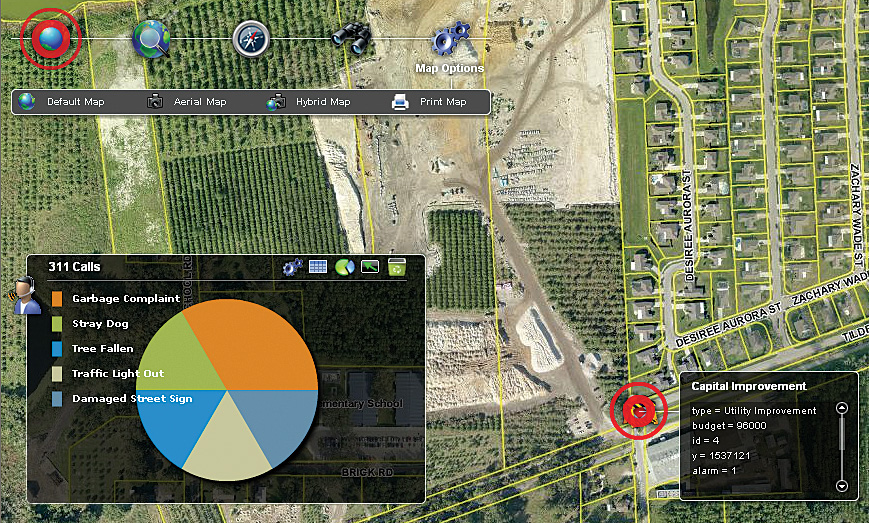
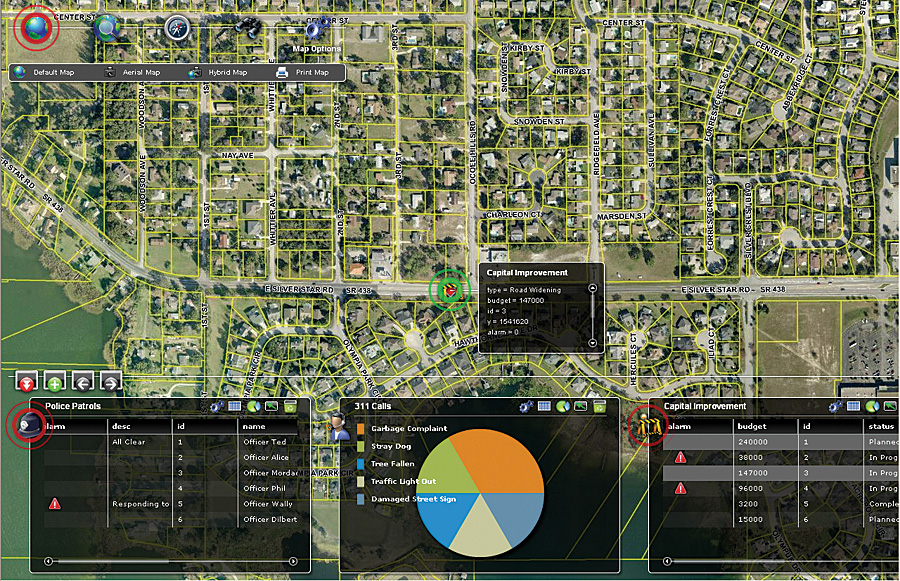
The ArcGIS API for Flex allows the developer to build rich Internet applications (RIAs) that run inside the browser but perform like a desktop application. End users must install the Adobe Flash plug-in to run the application. The API for Flex offers the same mashup capabilities as the API for JavaScript but provides even more opportunities to deliver visually rich and expressive applications that improve the user's experience and interaction with the information. For example, a Flex-based mashup could serve an executive dashboard for a county's public works manager to monitor the status of long-term projects or daily incidents. This type of enterprise mashup could contain dynamic charts and graphs and other types of reporting mechanisms needed for internal decision making. There are some points that should be considered before integrating multiple data sources in an enterprise mashup. For example:
These issues should be considered right at the start of any mashup development rather than deferring them until after the project is under way. ConclusionThe new APIs available with ArcGIS Server 9.3 give organizations a rapid development framework for creating, deploying, and managing enterprise mashups. GIS-based services and applications can deliver portal-like access to internal information resources and enhance the accuracy and reliability of decision making, as well as extend the range of what a mashup can do. Enterprise mashups reduce dependency on services that are external to the organization. More InformationTo learn more about building enterprise mashups with JavaScript and Flex, visit the ArcGIS Server Resource Center at www.esri.com/javascript and www.esri.com/flex. |