ArcUser Online
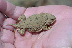
It all started in 1993 when Diane Petersen and Cathi Nelson, fourth- and fifth-grade teachers at Waterville Elementary School in the state of Washington, were investigating ways to engage their students in meaningful science inquiry. Traditional curriculum messages of saving tropical rainforests and endangered species had little appeal to youngsters most familiar with the farm fields in the high plateau of eastern Washington. Petersen and Nelson discovered the NatureMapping program, which was designed to develop citizen scientists (both students and community members) by nurturing the local knowledge of place through science projects created in collaboration with the needs of regional biologists. The NatureMapping program provides initial teacher training and guidance to implement a comprehensive curriculum based on scientific inquiry. The program then helps develop local projects in part to verify range distribution maps modeled for every terrestrial vertebrate in the state. The Development of a Long-Term ProjectEarly in the project development with Waterville Elementary School, students discovered that local observations of short-horned lizards (Phrynosoma douglassii) in farm fields were in conflict with the modeled range distribution maps. The statewide maps, created by the Washington Gap Analysis Project, were modeled from 96 historical observations presented in the 1997 report, Amphibians and Reptiles of Washington State: Location Data and Predicted Distributions. Though students and community members have lived with the lizards (also known as horny toads) in the farm fields, the modeled range distribution maps showed that the lizards weren't supposed to be there. Scientists, teachers, and students reviewed horny toad literature and local knowledge, developed a list of questions, and designed a spreadsheet with 22 attributes. Students first collated data on paper, then in the spreadsheet. Each year, the new students would use data from previous years to build their knowledge about scientific methodology, database management, and GIS. The new class of students would contribute additional data to the project and each year expanded the scope of the project to answer their own questions. Parents and Local CommunityIn 1999, the Adopt-a-Farmer project began. This project is a creative way to obtain more data by asking farmers to report observations when they are out in their fields. The fourth-grade students wrote letters to the farmers they wanted to adopt.
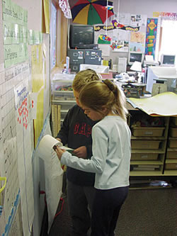
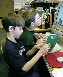
The NatureMapping program scientists supported the project by providing habitat descriptions and classification codes and worked with the students to design a data collection form. Students sent the form with instructions to their adopted farmers. Farmers were asked to visit the school in the fall and bring their data from the fields. In preparation for their first visit, the class created a slide presentation that introduced the project and GIS. Inviting the farmers, parents, and members of the local conservation district to help the students in a research project opened the door for questions such as What is GIS? What is Esri, and is that different from ArcView? What good is GIS in the classroom? How is this project going to help my child in school? Are horny toads an endangered species? The audience initially felt that GIS was a technology reserved for trained professionals and had difficulty imagining the technology being used by elementary school students. The audience was won over not only by the teachers' perseverance but also by the work students posted on their Web site and their explanation of what they did and why they needed more data. Visiting the ClassroomThe farmers were not only familiar with topographic maps, but they were also very good at training students how to use them. Horny toad sighting observations were marked on the maps and labeled with numbered dots. The other attributes from the data collection forms were reported on large poster paper at different stations within the classroom. After the farmers' visit, students used the labeled maps as the basis for on-screen digitizing of these locations using digital topographic maps in ArcView. Accompanying data was entered into the project spreadsheet at the same time. By the fourth year, Waterville students and their adopted farmers had collected more than 300 data observations. The expanding database was linked to the digitized points and overlaid on digital orthophotos and other statewide data coverage of rivers and roads. This allowed students to query the data and enforced database structure. It also helped these students develop a deeper sense of science inquiry. The cooperative development of a science plan that would work in the classroom and in the field with the farmers was critical for the long-term success of this ongoing school project. In addition, the observations provided by the participating farmers as well as the students helped these students become state experts on short-horned lizards. For students, it was important that GIS was used to answer their questions using their data. For teachers, it was about the genuine enthusiasm created by engaging the students in their local interests. GIS MentorshipThere were two roles for the GIS mentor. The first involved database management. Computers set up in the classroom and the school district computer network did not come with standard protocols for file storage and access. It was essential that the Waterville School District had outside technical support for GIS to help manage the data structure and nomenclature. Installing ArcView on a variety of classroom computers was efficient for teaching purposes as long as there was someone to help teachers maintain data integrity. The GIS mentor, whose phone number was written on the edge of the computer screen, could be called at any time when students were working with ArcView.
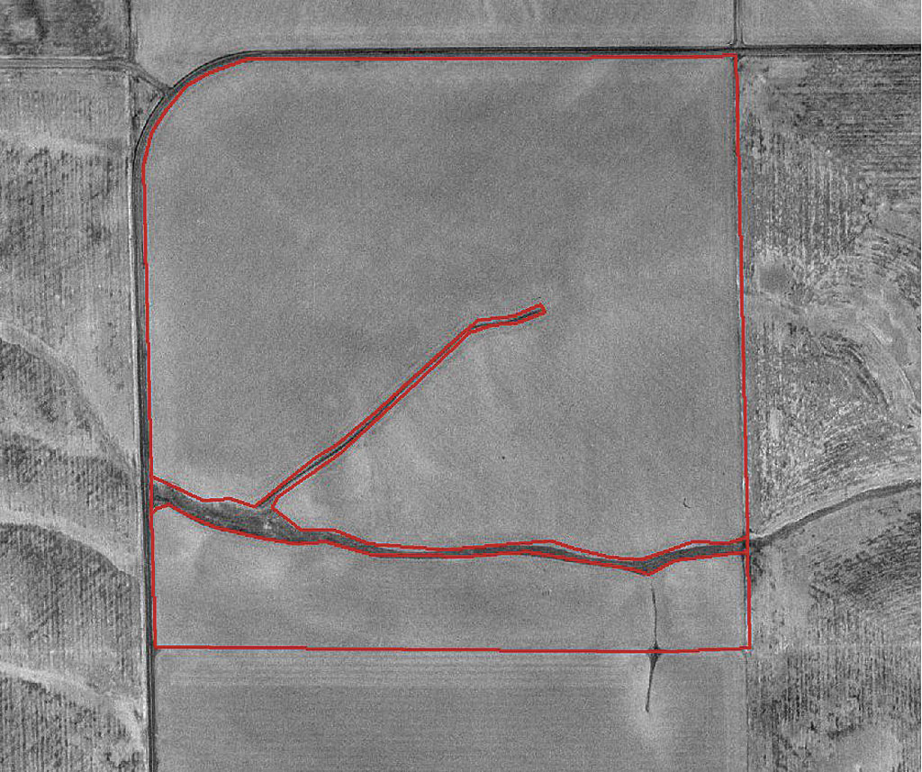
Students tended to select their type of involvement in the project based on expertise and interest. Many students had an aptitude for technology and were not afraid to learn and use ArcView. Typically, two to four students each year were taught Microsoft Excel and ArcView 3.2 by the GIS mentor. In turn, they trained their peers. Students not directly involved with ArcView assisted by writing text, making graphs, creating graphics, and taking and posting pictures for the Web site. However, all students learned to create map layouts of their farmers' lands and the associated horny toad observations. Support from School AdministratorsInitially, support from the community, school administration, scientists, and GIS mentors made it possible for the teachers to build their confidence and knowledge about scientific methodology, database management, and GIS. Students' questions prompted additional research, which resulted in the overwintering project, food preference study, behavioral studies, and the radio tracking project. Teachers also learned how to use other GIS tools for performing queries, making distance measurements, converting individual farmers' fields into separate shapefiles, and creating layouts. The database, which began with 96 historic records collected by scientists, now has more than 600 new records from farmers and students. The NatureMapping program's teacher training focuses on understanding the scientific, mathematic, geographic, and technical content necessary to teach what students need to learn to work on their projects as well as helping teachers understand how to connect what is taught with school district and state standard requirements for that grade level. Many components of GIS are part of the Washington state tests, even if GIS is not. The comprehensive integration of other subjects with the associated science gives students many avenues to contribute to a project in ways that interest them. As a result of the success of the Adopt-a-Farmer project, students have been asked to provide presentations in state and national conferences. Travel, presentations, and networking with the professional community as well as their own community have instilled a greater confidence in these students. Even the students' parents have become more interested in participating in the education process because the program is based on local knowledge. Continuing support by the Waterville School District administrators has allowed travel during school, helped cover substitute costs, helped find grants to cover equipment costs for fieldwork, and supported the teachers. It was also important that the mentors and the professional community provided financial support to the project to allow student travel, which has translated into success for everyone involved. In 2006Each fall, farmers come back to the classroom to submit their data to a new group of students. In 2006, students showed the farmers how to digitize their observations onto digital orthophotos. In the past, the farmers spent a lot of time watching students navigate to a location on the computer screen. Farmers expressed an interest in learning more about the technology, and they were given an opportunity to digitize the horny toad observations under the guidance of the fourth graders. Several students who were fourth graders in 2005 will present a book of maps that was requested by one of the farmers. The book contains the location of all the farmers' fields. Each field is highlighted and labeled with driving instructions, crops, and other information. This GIS project was more than creating maps and learning local geographic terminology—it allowed the students and the farmer to design and develop a project together. The students will offer other farmers the same product as an after-school project.
A significant change has come to Waterville Elementary School and the surrounding community. Farmers and community members are asking for specific maps. Students who participated in the project in previous years are being solicited for these projects. Teachers in the higher grade levels, with encouragement from school administrators, are trying to find ways to integrate these requests into their curriculum. Teachers are also beginning to ask their own scientific questions and wondering if GIS can be applied to these questions. A search for more GIS mentors in the community is taking place. The supporting scientist will continue to help teachers design projects that range from bird inventories, a map of healthy and diseased trees in the city, and insect bioblitzes (i.e., quick inventories) to finding what insects horny toads eat, addressing water quality and quantity issues, and locating noxious weeds on farmers' fields. These projects will be designed through a series of continuing NatureMapping workshops. Students that were involved in the Adopt-a-Farmer project now range from fifth graders to juniors in high school, and they are excited to get back to doing research projects. Some of these students may take over the more sophisticated aspects of the horny toad research project such as using data loggers and thermocouplers to see if horny toads do freeze in the winter. For more information, contact Karen Dvornich About the AuthorsKaren Dvornich is the cofounder and national director of the NatureMapping program in the Washington Cooperative Fish and Wildlife Research Unit at the University of Washington. She was the project assistant for the Washington Gap Analysis Project, where she was responsible for collecting all databases and datasets and led the amphibian and reptile distribution modeling efforts. Dan Hannafious works as a fish biologist and GIS technician for the Hood Canal Salmon Enhancement Group. He is also active in outdoor education—he provides overnight camps based on salmon activities as well as summertime "bat talks" to the community. He has been associated with the NatureMapping program since 1995 and helps identify the support mechanisms needed for NatureMapping schools using GIS. He can be reached at dan@hcseg.org. ReferencesDvornich, K. M., K. R. McAllister, and K. B. Aubry, 1997, "Amphibians and Reptiles of Washington State: Location Data and Predicted Distributions," Washington State Gap Analysis—Final Report, Volume 2, Edited by K. M. Cassidy, C. E. Grue, M. R. Smith, and K. M. Dvornich. Washington Cooperative Fish and Wildlife Research Unit, University of Washington. Seattle, Washington, 146. |
|||||||||||||||