Esri's Continued Commitment to Standards and Interoperability
One of the hallmarks of GIS is its inherently collaborative nature. GIS illustrates relationships, connections, and patterns in data. The unique integration capabilities of GIS bring together data from many sources for visual display and analysis, creating a more complete picture of a situation than would otherwise be possible. This enables organizations to make better decisions based on all relevant factors. For this reason, GIS technology has become an integral part of the information infrastructure in many organizations.
GIS Is Data-Centric
 |
| By developing products based on open standards, Esri has ensured a high level of interoperability across platforms, databases, development languages, and applications. |
Typically, GIS datasets are interrelated and often very large. Unlike business queries that may only return a few records, GIS queries for generating maps are routinely run against many thousands of features. This data usually comes from across an organization and, increasingly, from outside sources. Because GIS datasets are fundamentally distributed and dynamic, standards and interoperability have always been a fundamental part of GIS. This reliance on standards and interoperability has only deepened as GIS has moved from being a tool for individual projects and departments to become the framework for sharing information among organizations and across society.
The purpose of a GIS, or any information system, is to get answers to specific questions. Any GIS must produce information that answers these questions and share information among multiple users. GIS data management includes not only data collection but data dissemination. Interoperability enables data sharing between organizations and across applications and industries, which results in the generation and sharing of more useful information.
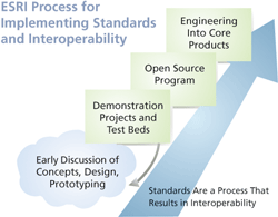
Building Working Standards
Just as GIS exists to produce information that answers specific questions, the goal of standards and interoperability should be to help GIS users build working systems that are practical to implement and use with the current GIS technology and IT environment.
Computing industry standards provide the foundation for GIS interoperability. Ultimately, GIS interoperability specifications and standards must fit within the context of broad and widely adopted computing industry standards. Esri realizes that it is necessary to evolve GIS interoperability within the world of ever-changing computing industry standards.
To be truly useful, standards aren't a product so much as a process. Often new specifications must still be tested in real-world scenarios and must evolve before widespread implementation is practical. In the final analysis, the needs of GIS users determine the role of any standard.
Support for standards will be engineered into Esri products based on user requirements employing the same three-step process Esri has been using when incorporating new technologies or types of functionality into its software. This process starts with a design phase, then a pilot/prototyping phase (which often results in delivery of new functionality as add-ons or extensions), and finally the software engineering phase that incorporates this functionality into Esri core products.
The Need for Standards and Interoperability
The GIS community in general, and Esri in particular, has been pursuing open standards and interoperability for many years. Interoperability is the ability to combine information and functionality from different systems. During the past 20 years, the concepts, standards, and technology for implementing GIS interoperability have evolved. The approaches listed in Figure 1 play a significant role in GIS interoperability.
| Strategy |
Example |
| Data converters |
DLG, TIGER, MOSS, GIRAS, IGDS |
| Standard interchange formats |
SDTS, DXF, GML |
| Open file formats |
VPF, shapefiles, DGN |
| Direct read application programming interfaces (APIs) |
ArcSDE API, CAD Reader, ArcSDE CAD Client |
| Common features in a DBMS |
OGC Simple Feature Specification for SQL |
| Integration of standardized GIS Web services |
WMS, WFS |
Figure 1: Evolving strategies for interoperability and standards.
Initially, the constraints of computational speed, and its associated cost, limited the choice of strategies and focused efforts on implementing data sharing. Practical solutions, such as data converters, transfer standards and, later, open file formats, have enabled data sharing between organizations with different GIS vendor systems. However, sharing spatial data with core business applications was rarely possible.
Today, most GIS products directly read, and sometimes dynamically transform, data with minimal time delay. In addition to developing numerous data converters, Esri software supports direct read access for Spatial Data Transfer Standard (SDTS), Vector Product Format (VPF), imagery, CAD files, digital line graph (DLG), TIGER files, and other standard interchange formats.
Continued on page 2
|
