ArcWatch: Your e-Magazine for GIS News, Views, and Insights
May 2011
Access American Community Survey Data Instantly in Esri Business Analyst

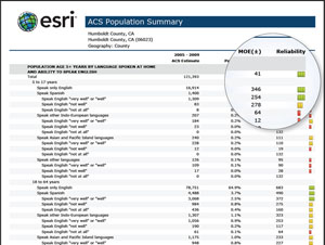
ACS data in BAO reports include a Margin of Error number and easily understood color-coded symbols that alert data users to the reliability of the ACS estimates.
When a business needs to find a new market or evaluate how well its current locations are performing, data from the American Community Survey (ACS) can help.
Conducted by the US Census Bureau, the ACS supplies the data the bureau once collected during the decennial census. Two ACS reports are now available in two reports through Esri Business Analyst: The ACS Population Summary and the ACS Housing Summary. Esri enhanced both reports by adding reliability symbols to alert readers if small sample size impacts the accuracy of specific data.
The ACS Population Summary and ACS Housing Summary reports contain data from the ACS 2005–2009 five-year-period estimates. The ACS Population Summary offers demographic variables such as marital status, language spoken at home, school enrollment, income, and poverty status. The ACS Housing Summary provides data on home value, mortgage status, rent, number of vehicles, and more.
Business Analyst subscribers can instantly access the reports or view the ACS data with color-coded thematic maps. Users without a subscription can purchase the ACS summary reports by creating a Business Analyst Online (BAO) guest account.
Changes in Decennial Census Data Collection

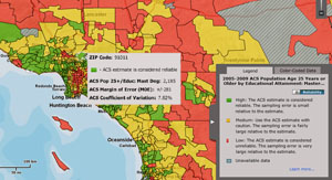
Users can thematically map the ACS estimates on Business Analyst Online and then view the associated reliability for the estimate using the Reliability toggle in the map legend.
In 2010, the US Census Bureau changed how it collects decennial census data. The bureau eliminated the traditional long form, opting instead to gather data from everyone using only the short form.
Data previously obtained from the long form is now provided by the ACS, a rolling survey that represents a period rather than a point in time. Gathered from randomly selected households and incorporating variables in addition to those in the summary reports, the ACS data also includes information about education attainment, employment, migration, travel time to work, marital status, and housing.
Esri data users will have access to many more data variables annually; however, because it comes from a survey, the ACS data will include a margin of error (MOE).
The ACS Margin of Error
All survey-based estimates are subject to sampling error. The MOE displayed with ACS data measures the variability of the estimates. MOEs enable data users to measure the range of uncertainty for each estimate with 90 percent confidence. The range of uncertainty, called the confidence interval, is calculated by taking the estimate number plus or minus (+/-) the MOE. For example, if the ACS reports an estimate of 100 with an MOE of +/-20, there is a 90 percent certainty that the value for the whole population falls between 80 and 120. To learn more about the ACS and the MOE, read the American Community Survey white paper written by Lynn Wombold, Esri’s chief demographer.
How Can Ignoring the MOE Impact Data Users?
Ignoring the MOE on the ACS estimates could severely impact analysis results. For example, companies could misinterpret income and population figures and offer an ineffective product mix in certain markets. Retailers could open a store in the wrong area, costing time and money as they deal with a poorly performing store. To help companies avoid these costly mistakes, Esri’s data development team devised a system of reliability symbols that indicate when users can depend on the ACS sample estimate or when the sampling error becomes too large.
“When our clients asked us to simplify their use of the ACS data, Esri responded by adding easily understood, color-coded symbols to our reports that quickly identify which ACS estimates are reliable,” says Catherine Spisszak, Esri data product manager. “This innovation means our clients no longer have to interpret the ACS MOE themselves. It also provides them with more accurate data to make better business decisions.”
Added Value to the ACS Data
Esri’s data development experts have also added additional value to the ACS variables by offering them for nonstandard geographies such as ZIP Codes and user-defined polygons, including drive times, rings, and custom trade areas, not supplied by the Census Bureau.
“More than half of data users employ rings, drive times, and hand-drawn shapes. Esri is the only vendor to provide ACS data for these nonstandard geographies,” says Spisszak. Learn more about the ACS Summary reports or call 800-447-9778. To view the ACS data and MOE for standard and nonstandard geographies, sign up for a free 14 day Business Analyst Online trial.