
The foundation of property rights rests on two simple questions: Who owns what, and where is it? For centuries, cadastres—official property registries—answered these questions in 2D. But as cities have evolved, officials in Türkiye realized they needed a third dimension—one that would extend vertically across the entire country.
The result is a national initiative to map every building, parcel, and property boundary in 3D, from Istanbul’s historic skyline to the ancient streets of Ankara. By providing a digital foundation for 21st-century cadastres, this effort will transform how Türkiye manages property rights.
Understanding the Foundation of Property Rights
A cadastre is an official register that documents the ownership, boundaries, and value of real property. Historically maintained as paper records and 2D maps, cadastres have since evolved into digital systems. Adding a third dimension—height—unlocks entirely new capabilities.
“The third dimension’s importance really kicks in when you consider things like boundaries and volumes,” said Yavuz Eren, CTO of Esri partner MipMap Technologies, which leads the project in Türkiye.
In countries where property taxes are based not just on land area but also on the volume of constructed space—like in Türkiye—these volumetric calculations matter for taxation as well.
-
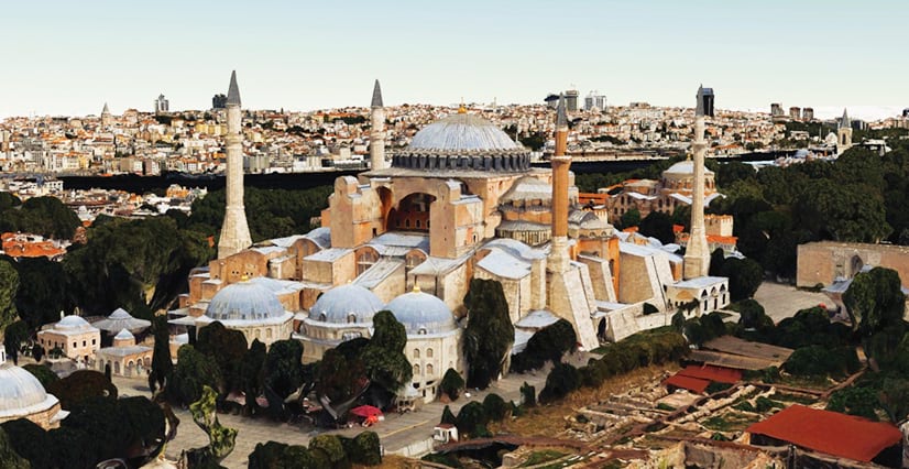
Türkiye is on a mission to map every property in the country in 3D, from Istanbul’s historic buildings like the Hagia Sophia (shown here), to the streets of Ankara.

A Unique, Integrated Platform
The project integrates Türkiye’s disparate property data systems into a single, authoritative platform.
“This project unifies outdoor and indoor 3D city modeling, parcel-building-unit relationships and inventory, cadastral integration, and advanced 3D GIS analysis into a single, end-to-end operational system,” Eren said.
Istanbul serves as the initial testing area, with about 1.3 million buildings mapped in a citywide digital twin. MipMap CEO Cenk Şen said that Türkiye started with Istanbul because of the size of its data repository, as well as its earthquake risk, economic impact, complex building stock, and data challenges.
“If the system can succeed at an Istanbul scale, it can be deployed anywhere in the country,” he remarked.
After Istanbul, the model will expand to cover the rest of Türkiye, enabling a next-generation approach to property management. It will help address—on a country-wide scale—issues such as earthquake risk, rapid urbanization, national digital transformation goals, administrative needs, and economic motivations.
ArcGIS Reality Drives Additional Solutions
Türkiye’s cadastre authority evaluated multiple solutions before selecting ArcGIS Reality as the foundation for creating high-fidelity 3D content. The decision came down to geospatial accuracy, visual realism, performance, and the ability to integrate diverse data sources.
The next step was identifying a partner. With more than 25 years of photogrammetric experience, MipMap quickly demonstrated what the technology could achieve.
“ArcGIS Reality generates 3D textured meshes that preserve straight edges and fine details and eliminate distortions,” said Şen, adding that the project uses 10-centimeter-resolution imagery.
The software delivers survey-grade accuracy that’s essential for cadastral applications. It also supports distributed processing across multiple machines so it can be implemented at large scales.
-
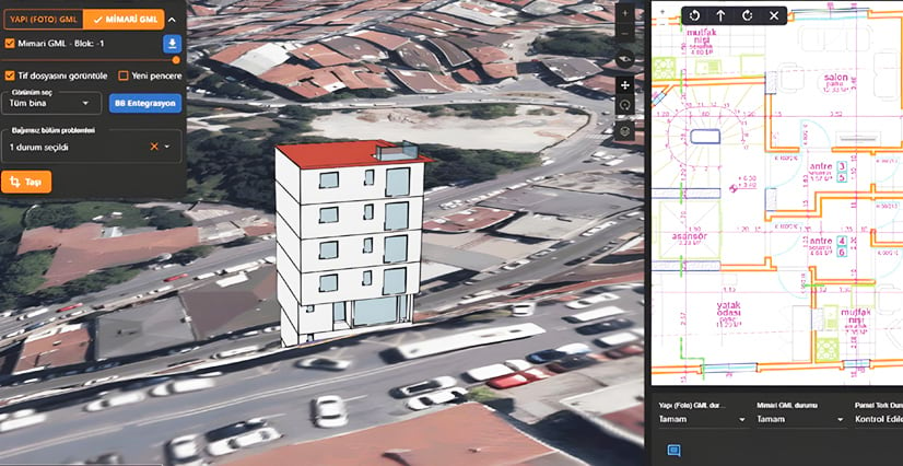
The project incorporates building-specific 3D imagery with floor plans, ownership information, construction details, and more.
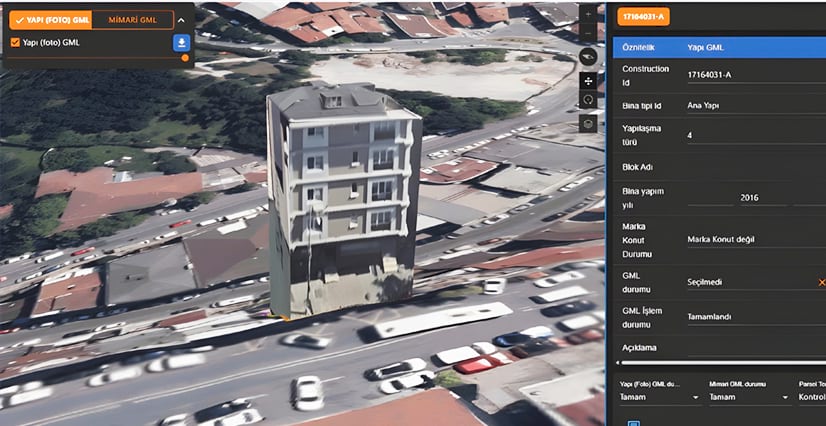
Beyond the core Reality mapping with ArcGIS Reality, the broader Esri ecosystem proved essential.
“The real hero of this project is actually ArcGIS Enterprise,” Şen said, noting its high-availability structure, performance monitoring tools, and integration with field apps such as ArcGIS Field Maps and ArcGIS Survey123.
Advanced urban analysis and Internet of Things (IoT) integration will eventually help with projects related to property valuation, urban planning support for earthquake resilience, environmental simulations for flood prevention, and noise and air-quality mapping, according to Eren.
In one district of Istanbul, the system uses 3D building models, structural data, simulation models, and AI to estimate which buildings, floors, or units might experience the most shaking during an earthquake. AI can also simulate added trees, changed bus routes, and redesigned intersections to make targeted areas quieter and healthier.
Overcoming Challenges with Data
Even with more than 200 MipMap employees and subcontractors working on the project, MipMap faces significant technical and logistical challenges.
One involves combining three distinct data formats: a city-scale semantic model (including building types, uses, construction information, and topology), building-scale interior architecture data, and digitized photogrammetric building data. The solution requires sophisticated automation, semantic mapping, geometric cleaning, and a geospatial database that can handle both 3D geometry and building-level semantics.
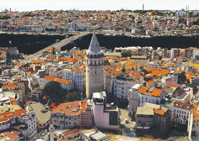
Another challenge involves keeping the massive dataset current. To detect change, the team compares periodically collected aerial imagery with existing models and combines that with digitized building permits that trigger updates when approved, ensuring that the model stays current and accurate.
A Blueprint for the Future
Eren sees potential for new applications of landscape-wide, digitized geospatial analysis.
“We have to come up with new approaches in terms of extracting value from urban-scale digital twins,” he said, noting the need for better coordination regarding revenue sharing and service creation.
He envisions companies in fields such as real estate analysis, energy efficiency, and environmental simulation being able to build apps atop a foundational model for sustainable development and data-driven urban planning. This could inform solar energy analyses and citywide building retrofitting projects. Economic benefits include 3–12 percent increases in property tax revenues as unmapped areas become visible, plus operational cost savings via automation, according to Eren.
“Organizations can save more than 20 percent on inspections, zoning checks, and valuation processes, as much of this work is automated,” he said. “City planners, emergency teams, and utility providers also benefit from accurate 3D data, avoiding mistakes and making infrastructure investments more efficient.”
Sohail Elabd, Esri’s global director of emerging markets, said the project is noteworthy not only for the scale of its 3D modeling but also the fact that it’s built as an operational system.
“Türkiye’s approach shows how geospatial technology has moved beyond maps to become part of core government workflows,” Elabd said. “A national 3D cadastre creates a digital backbone for modern cities—supporting resilience, efficiency, and transparency, and setting a benchmark for other countries as they modernize their land and property systems.”