Many people now contend that climate change has emerged as a pivotal global issue and that humanity has officially entered a new climate era. United Nations (UN) secretary general António Guterres has gone so far as to declare that we are in an era not of global warming, but of “global boiling.”
The global geospatial tech community continues to work steadfastly to address this singular challenge of our time. This was evidenced by the popularity of Esri’s first massive open online course (MOOC) on the subject, offered last year. The class, called GIS for Climate Action, was held from October to December 2023 and attracted remarkable interest, with about 16,600 participants globally.
The MOOC is available again this spring, from May 1 to June 12. Register now to explore how to create clarity from a myriad of climate data sources and illuminate climate-related risks, opportunities, and sustainable solutions. Course videos, exercises, and discussion boards will show how the latest ArcGIS capabilities can be deployed to monitor climate change indicators, predict associated natural hazards, understand coastal flooding impacts, model sea level rise, identify solar energy potential, predict natural hazards, and create insight and—most importantly—drive positive action toward a more climate-resilient future.
In addition to the MOOCs, Esri remains actively involved in a multitude of climate-related activities. This column highlights a few of them.
It’s my opinion that the world is paying more attention to the annual UN Climate Change Conference and the UN’s Conference of the Parties (COP). This event—also referred to as the Climate COP—brings together government policymakers, activists, scientists, industry leaders, and journalists from across the globe to assess the latest science about the climate crisis and develop global goals aimed at slowing climate change and mitigating the worst of its impacts. Esri and its distributors local to the host nations have participated in the last few COP events (COP26 in Glasgow; COP27 in Sharm El-Sheikh, Egypt; and COP28 in Dubai) and are expected to participate in COP29 in Baku, Azerbaijan, in late 2024.

Esri has also had strong representation at the “other” COP—the UN Biodiversity Conference, also known as the Biodiversity COP, the most recent of which was COP15. This global meeting occurs every two years at locations separate from the Climate COP, and focuses on the international Convention on Biological Diversity (cbd.int). One of its most significant outcomes has been the landmark agreement to protect 30 percent of the planet’s lands, inland waters, coasts, and ocean by 2030. This is often referred to in the media as 30×30 or 30 by 30.
Although the climate and biodiversity COPs have acted independently of each other, there’s growing consensus among scientists, natural resource managers, and conservation activists that the two should be inextricably linked, and that we need solutions that tackle climate and biodiversity simultaneously. Indeed, climate solutions can promote biodiversity.
More specifically, the International Union for Conservation of Nature (IUCN) recently announced Esri as its geospatial partner on the IUCN Act30 initiative, which aims to advance 30×30 in 18 countries. Via this initiative, national conservation planning maps will be developed for each country, highlighting Indigenous Peoples areas, key biodiversity areas, and protected and conserved areas. Other partners are the High Ambition Coalition (a new 30×30 organization funded by the World Bank Global Environment Fund), and the International Indigenous Forum on Biodiversity.
Esri has also been collaborating with the Group on Earth Observations to conduct a global, crowdsourced assessment (using ArcGIS Survey123 and ArcGIS StoryMaps) of how citizens, policymakers, and local governments are experiencing heat impacts in their communities. Responses will be combined with existing data and new satellite feeds to develop the Global Heat Resilience Service (GHRS).
The GHRS will leverage the power of high-resolution data in the cloud, augmented by AI, to help city planners understand when and where extreme heat events will occur, as well as varying vulnerability levels and what actions will best manage risks. This service, currently in the design phase, is intended to be a trusted, free, and openly accessed decision-support tool for major cities.
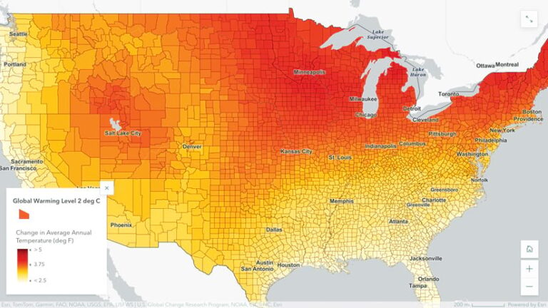
In the United States, many people now recognize the National Climate Assessment (NCA) reports, mandated by the US Congress, as the preeminent source of authoritative information on the risks, impacts, recommended responses, and best solutions to combat climate change for the country.
For the fifth annual iteration of this report (NCA5), more than 500 climate science experts from across the nation and thousands of additional stakeholders from state, local, and federal government organizations; nongovernmental organizations; and industry were engaged in the process. Unlike previous NCA reports, NCA5 is accompanied by the new NCA Interactive Atlas (atlas.globalchange.gov), powered by Esri technology. The atlas provides interactive, online access to the climate projections used in the report and helps users better understand the guidance and tools in NCA5. It uses hundreds of interesting and insightful maps that drive home climate change impacts with all the detailed information that is in NCA5. This is essentially the decision support needed for climate resilience planning across the country, even down to the scale of individual communities.

More good news is that the Bezos Earth Fund has recently established the largest philanthropic commitment ever to fight climate change, by way of protecting nature. Esri has a new partnership with the fund that involves collaboration with Columbia University and the University of Albany to better understand how people are using AI to combat the climate crisis. This will result in a landscape assessment report to help inform and guide the fund as it provides philanthropic support to further innovation in the AI and climate space.
These are just a few of the many climate projects and solutions that Esri is involved in with our users and partners. This is a time of “purposeful frenzy” at Esri, as climate change continues to be one of the critical challenges of our time, requiring immediate and effective action. I hope these developments will encourage and inspire you to participate in or spread the word about them whenever and wherever possible.


