Climate change is one of the defining issues of this generation. More frequent and extreme weather events, along with gradual, longer-term changes to the environment, are impacting people’s lives.
According to the World Meteorological Organization, 2021 was one of the seven warmest years on record—and the last seven years have been the warmest in history. This was punctuated with record drought in South America and unprecedented flooding in Asia and Europe. Notably, some of the most extraordinary weather events in 2021 didn’t occur in typically warm areas. Canada shattered its record-high temperature by hitting 49.6 degrees Celsius (121 degrees Fahrenheit) in British Columbia at the end of June.

No place in the world is immune to the effects of climate change. Combating this crisis necessitates new ways of thinking and behaving. To understand changing climate conditions, anticipate future impacts, and drive mitigation and adaption strategies across all aspects of society, people need access to sound data, tools, apps, and workflows. This will require unparalleled collaboration—and a geographic approach.
Champions of Climate Change Are Already Taking Action
The climate-based challenges the world faces are not new, and there are already champions of climate change around the globe.
At the end of 2021, global leaders, scientists, and impassioned youth came together at the United Nations (UN) Climate Change Conference, COP26, to commit to taking collective, meaningful action in response to climate change. In early 2021, one of US president Joe Biden’s first acts in office was to sign a comprehensive executive order on climate change that calls for a whole-of-government, science-driven approach to addressing the crisis. The European Green Deal, which seeks to make the European Union climate neutral by 2050, strives to engage all people in climate action.
Governors, mayors, and community leaders around the world are working on climate resilience plans that span the neighborhood level to whole regions. Local governments are evaluating new infrastructure projects for future climate risks, retrofitting buildings to improve energy efficiency, and taking a geographic approach to siting areas for wind and solar energy generation. They are also mapping out where to equitably install electric vehicle (EV) charging stations and establish interstate EV corridors.
At the same time, private companies are evaluating climate-induced vulnerabilities in their facilities and supply chains to protect their businesses and be more responsible corporate citizens. Delivery companies are analyzing driving patterns and location characteristics to evaluate how to electrify their fleets. Architecture and engineering firms are applying climate-smart principles to their project designs, and health-care providers are rethinking public health issues as climate change alters the way diseases spread. Nonprofit organizations as well are working strategically to conserve land and water, enhance nature-based climate solutions, and help governments and businesses harness new ideas and technologies.
Many of the innovators in these spheres are Esri users, and many others would like to leverage these users’ experience. Esri is well positioned to assist. As a company that has always had the vision that geospatial technology could be used for a higher purpose—to help design a more sustainable world—Esri operates on the notion that supporting the needs of one often benefits many.
New Climate Initiatives at Esri Focus on Collaboration
For more than 30 years, Esri has been collaborating with users in the climate community, ranging from climate researchers to staff at national weather agencies. In the early 1990s, for example, Esri teamed up with the National Science Foundation in the United States to study the hole in the ozone layer and do Antarctic solar radiation modeling. Esri’s work on climate-related initiatives has expanded over the years to the point that the company was awarded a top ranking in the Forrester New Wave: Climate Risk Analytics, Q3 2020 report.
Recognizing the growing urgency to scale up its climate efforts even more, Esri formed a new climate team last year, pulling together experts from across the organization to institute a more comprehensive approach to tackling the crisis. Out of this came five focus areas that are already reshaping Esri’s work.
Mitigate Changes to the Climate
Esri’s climate initiative begins with climate mitigation measures that support users’ efforts to reduce greenhouse gas emissions. This builds on previous work Esri has done to help find sites for alternative energy production, model transportation alternatives, and assist with sustainable land and forest management.
Carbon capture company Summit Carbon Solutions, for example, recently adopted ArcGIS technology to help with its efforts to trap and store carbon dioxide before it gets emitted into the atmosphere. In addition, the United States Department of Agriculture, in league with the European Union, is using ArcGIS to map areas that have the highest potential for carbon sequestration to determine which farm management techniques to invest in.

Understand the Impacts of Future Climate Conditions
To prepare for future climate conditions, planners and designers need access to future climate scenarios and impact modeling results. Twenty years ago, Esri collaborated with a team at the National Center for Atmospheric Research (NCAR) to incorporate netCDF (network Common Data Form) into ArcGIS and help make it an Open Geospatial Consortium, Inc. (OGC), standard. Since then, Esri’s work with NCAR has grown to the extent that data using CMIP5 and CMIP6 climate projections is published in ArcGIS Living Atlas of the World, and Learn ArcGIS lessons have been built around it.
Esri will continue to make climate projection model outputs easy to use and is committed to helping others understand how to appropriately employ this data. Layers slated to be improved and updated include projections of future temperature, precipitation, sea level rise, and inland flooding extents and frequency—all of which can be used to model future climate-related impacts. Esri will also expand related tools and workflows.
Assess Risk to People and Property
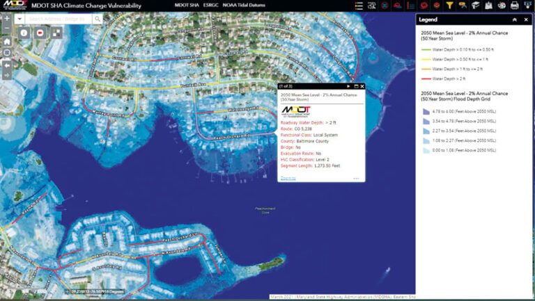
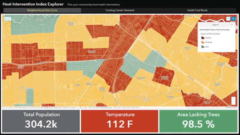
Impact maps that show things like where flooding is likely to happen in 2050 are powerful decision-making tools when overlaid with population projections, planned infrastructure, ecosystems, and other data to determine who or what will be at greatest risk. For example, being able to analyze national heat indexes can help decision-makers see where to place cooling centers, install cool roofs, and plant trees.
Esri is developing new workflows, ArcGIS Hub solutions, and Learn ArcGIS lessons to streamline risk assessments and help governments and businesses prioritize critical areas for intervention. The Esri partner community also provides climate-focused solutions and services, like the climate risk data products from Mayday.ai and tailored climate resilience planning from FernLeaf Interactive.
Geodesign with Climate Awareness
Designing and developing spaces is always an exercise in balancing competing goals. Now, assessing current and future climate risks is part of that consideration.
To help planners, resilience officers, and those who are not GIS or climate experts make well-informed decisions, Esri is developing replicable solutions and publishing data that focuses specifically on climate issues. These are being rolled out alongside training programs that show users how to properly leverage content from ArcGIS Living Atlas along with their own high-resolution and potentially more recent data.
The strength of this approach is in partnering with experts to organize relevant, high-demand climate data and make it easy to use through apps and workflows. For instance, for the recent Climate-Smart Communities challenge, put on by The Opportunity Project, Esri put together a Hub template for extreme heat, complete with data and tools that guide users through five steps for making resilience plans. Esri is now building out this resource pattern for other threat themes, including wildfires and floods.
Communicate to Educate and Spur Action
To put all these great resources to use, people need to understand the challenges that lie ahead, plus the pathways available for making progress. That means the GIS community needs to engage with and educate the public to prompt action.

In the United Kingdom, Esri UK recently teamed up with the country’s Meteorological Office to create GIS-based lessons for K–12 students that help them interpret complex scientific data about the climate. The idea is to show young people how they can build knowledge around climate change and motivate their peers to act to fight it.
One tool that kids and adults alike find useful for communicating ideas is ArcGIS StoryMaps, a story authoring app that makes it easy to build narratives around maps and data. Esri has released new Learn ArcGIS lessons that teach participants how to employ ArcGIS StoryMaps and other user-friendly software to raise awareness of climate initiatives and encourage involvement.
Esri is also currently working with Project Drawdown, a nonprofit dedicated to bringing greenhouse gas emissions into decline, to add interactive mapping experiences and apps to its two educational series, Climate Solutions 101 and Climate Solutions 201. The online courses aim to help leaders in business, philanthropy, investment houses, and communities think strategically about finding climate solutions.
Technology Is a Crucial Part of the Process
By far, Esri’s biggest contribution to fighting climate change is in empowering GIS users to plan for it and take action. There are only a few thousand employees at Esri, but Esri has hundreds of thousands of users who, in turn, serve millions of people.
To ensure that GIS solutions work together to tackle the climate crisis, Esri is collaborating with users from various sectors to learn about their challenges, workflows, and new opportunities to act. This has already revealed many common business drivers and needs for data and apps.
Esri will continue to focus on its efforts to assist all users in addressing their organizations’ sustainability needs. As Esri president Jack Dangermond said, “We recognize the seriousness of the climate crisis, and we know full well that technology will be a crucial part of the solution.”


