One responsibility of the US Food and Drug Administration (FDA) is protecting and ensuring the safety of the country’s food supply. For a study that began in 2023 and is scheduled to end in 2027, the FDA national retail food team is collecting data on foodborne illness risk factors in US retail food service facilities. The study assesses food safety practices and procedures in areas such as employee handwashing, prevention of bare-hand contact with ready-to-eat food, and prevention of cross-contamination. It builds on data from a 1998–2008 study that established a baseline for these factors.
According to Dr. Guilan Huang, regulatory information specialist for the FDA Center for Food Safety and Applied Nutrition, such studies measure practices and behaviors identified by the US Centers for Disease Control and Prevention as contributing to food-borne illness outbreaks. The studies also measure progress in reducing foodborne illness risk factors, examine the relationship between known risk factors and food-handling practices, and evaluate the effectiveness of food safety management systems and certified food protection managers.
Using GIS to Overcome Resource Limitations
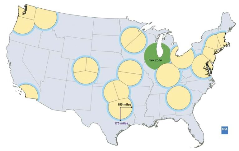
The National Restaurant Association estimates that there were 749,000 restaurants in the United States in 2023. However, the FDA has only 20–24 retail food specialists available at any one time for data collection. Because of the limited number of specialists and the travel needed for data collection, the FDA needed a random sampling procedure that provided a high level of accuracy and that minimized travel time. And because of the length of the multiyear study, a flexible method was needed that could be easily adapted for changes in collection areas, personnel, or procedures.
After investigating different methodologies, the FDA selected spatially random sampling, which involves random selection of sample facilities in which each facility has an equal chance to be selected. Huang implemented it by creating buffered areas centered on the specialists’ ZIP codes.
Using ArcGIS Business Analyst for the desktop and the product’s accompanying datasets, Standard Industrial Classification and North American Industry Classification System codes from the US government were applied, Huang said. She added that multi-layer filters were created using the codes, key words extracted from the FDA’s Retail Food Risk Factor Study, and data from the previous 10-year study and the current study.

“Spatial analysis was fundamental in conducting this study because it allowed us to customize cost-effective spatially random sampling and perform rigorous quantitative analyses,” Huang said. She added that she hopes that the research will lead state, local, tribal, and territorial agencies as well as industry to develop and implement retail food safety policies and initiatives that target specific interventions that reduce foodborne illness risk factors.

