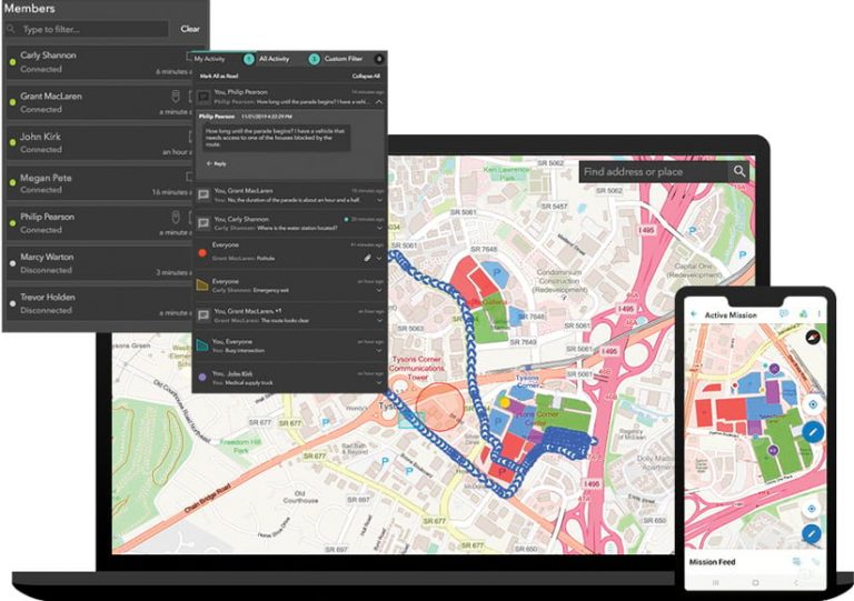
ArcGIS Mission is a new geoenabled system that organizations—from public safety and law enforcement agencies to utility and natural resources companies—can use to streamline mission management; gain situational awareness during active missions; provide geospatial-based, peer-to-peer communication in the field; and conduct postmission reviews. The software enables teams to better understand their operations, make informed decisions in real time, and acquire new intelligence from completed missions.

Mission offers the core capabilities of other tactical situational awareness solutions, but it also streamlines mission workflows and integrates directly with other ArcGIS technology to provide new capabilities. Key features include
- One platform for mission management. By using Mission, organizations can reduce the number of systems they use to manage both planned and unplanned missions, events, and operations. As a single platform, Mission lets users create, manage, and save mission data that can be accessed within their organizations. This makes it easier for teams to plan, execute, and review missions. The software also streamlines the delivery of mission planning materials, allowing organizations to quickly share maps, images, location information, and other related content to team members in the field, who can download it all directly to their mobile devices.
- Tactical situational awareness. Mission lets people—both in the field and in the command center—see the locations of mission members in real time. This makes it easier to coordinate movements among team members based on in-progress events and activities. Everyone participating in the mission can monitor the situation and quickly make adjustments. Participants can also use location, photos, and other information from the field to identify team vulnerabilities early and plan effective responses.
- Peer-to-peer communication. By providing persistent, peer-to-peer (P2P) communication, Mission lets team members send messages to each other for stronger collaboration and real-time decision-making. They can also share locations and location tracks, map markups, photos, and videos so everyone on the team has the information they need. P2P communication is supported in connected, low-bandwidth, and disconnected environments.
- Support for improved understanding. With Mission, all the data created and collected during a mission is saved in ArcGIS. Organizations can leverage this continually updated mission data to gain new insights, increase transparency, and build trust. Saved data includes both the data created when the mission is defined and the data gathered while the mission is active, such as chat messages, photos, and the location tracks of team members. Once this data is saved, users can view and analyze mission data in other ArcGIS apps, such as ArcGIS Dashboards or ArcGIS Insights, to improve their understanding of mission activities.
What’s Your Mission?
To learn more and add ArcGIS Mission to your organization’s ArcGIS Enterprise deployment, get in touch with an Esri representative.
The three components of ArcGIS Mission are as follows:
- ArcGIS Mission Manager is a premium app that organizations can use to manage their missions, assign mission members, and distribute mission content.
- ArcGIS Mission Responder is a mobile app that mission members can use in the field to share location tracks, map markups, and photos.
- ArcGIS Mission Server is an ArcGIS Enterprise server role that enables peer-to-peer communication among all mission team members.
Watch Esri staff members use Mission at the 2020 Esri Federal GIS Conference in February to simulate searching for a person of interest and securing the Walter E. Washington Convention Center in Washington, DC.

