Countdown, the newest app template in ArcGIS Instant Apps, shows a specified number of top or bottom features in a map, sorted by a particular attribute. With it, data journalists, decision support analysts, and
others can deliver an interactive, data-driven tour of specific features. Countdown was out of beta as of the December 2021 release of ArcGIS Online. Like all Instant Apps templates, you can easily place your web map in an app from within the new Map Viewer.
In addition to the countdown functionality, an interactive Leaderboard (sorted list) section provides an at-a-glance view of multiple features. The Details section helps orient viewers and tell a complete story by providing context alongside the map. There are three major section types: Details, Countdown, and Leaderboard. Adding and reordering these sections is simple to do in the configuration panel.
In the app itself, the sections appear in the side toolbar. People viewing the app can experience each section and click Next at the bottom to navigate through or click the sections on the side toolbar for a self-directed experience.
Details
The Details section is text based and designed to help provide context alongside the map. Give the Details section a name, such as Introduction or Conclusion, and it will appear on the side toolbar of the app. Details sections can be used to tell a narrative story around the trends and geographic differences presented in the app, along with some key takeaways. These sections are also a great place to provide definitions, sources, and more information.
Countdown
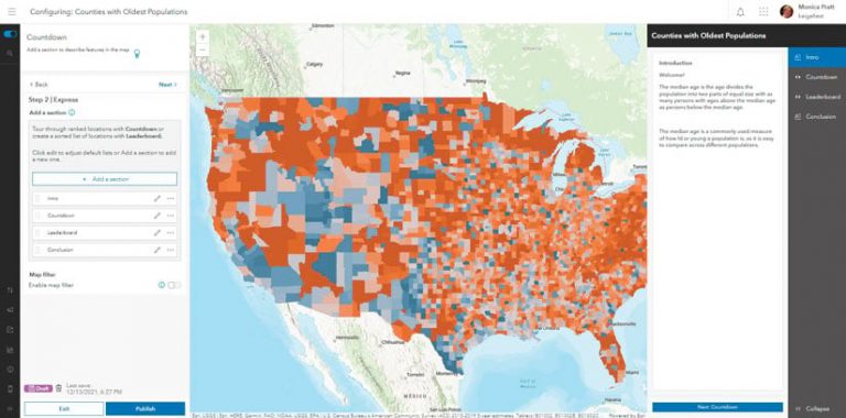
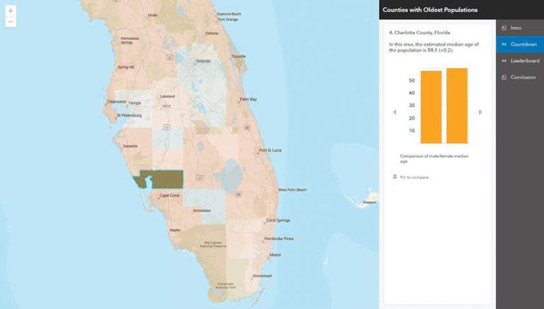
The Countdown section is the bread and butter of the Instant Apps experience. It’s a guided tour of the top (or bottom) features of the map. Sorting is based on the attribute chosen. The information displayed on the side comes directly from the web map’s pop-up, including any charts, images, or other media. In this example app, 10 was chosen as the number of features, and Median Age of Total Population as the attribute to display the top 10 counties with the highest median age.
Leaderboard
Accompanying the map-based countdown experience is an optional list-based Leaderboard section. The Pin to Compare button allows the app’s viewers to pin a particular feature to compare with others on the list. Up to two pop-ups can be docked for comparison. The Leaderboard section does not need to have the same number of features as the countdown. With more features listed, there is a greater potential for ties. The numeric rankings on the list honor ties in the data.
In this example, the leaderboard has a list of the top 15 oldest counties, whereas the countdown goes through the top 10. For example, there are two counties in the United States with a median age of 57.4 years. These two counties are both ranked 13th, and the next ranking displayed is 15th because there is no county ranked 14th.
Express versus All Settings
Upon entering app configuration in Instant Apps, Express Setup is the default mode. It is a quick way to get started by only configuring the core options. For more control over the app, enter All Settings.
All Settings includes options such as the following:
- Having the legend show up when the app loads
- Changing the placement of app widgets through the Position Manager
- Choosing a Light or Dark theme or shared theme to take advantage of branding colors set by your ArcGIS Online organization’s administrators
Interactive Viewing Experience
Those viewing your app can interact with any feature in the map, not just those highlighted in the Countdown or Leaderboard section. This allows viewers to see and dock the pop-up for their own feature of interest, such as their own county, school district or other boundary layer and compare it to those highlighted in the app.
Release Enhancements
This app is now out of beta as of the December 2021 release. The main enhancement with this release is the ability to apply a map filter. Most maps available in ArcGIS Living Atlas of the World have nationwide or even worldwide coverage. Many users have told Esri that they need to filter these maps to the state or county level. Previously, this was done by filtering in the Map Viewer itself and saving a filtered map to use in Instant Apps. With the new Map Filter capability in Countdown, a nationwide map can be filtered within the app configuration experience.
In this example, in step 2 of the Express Setup adding sections, a map filter can be applied to the county-level layer such that the attribute called State is equal to Texas. Now, although the web map still covers the nation, the app counts down and maps only counties in Texas.
Other Enhancements
In addition to Map Filter, other capabilities, such as Navigation Boundary and Custom Theme, are now available in Countdown along with improvements for mobile viewing.