Oil and gas industry operations are divided into three stages: upstream (exploration and production), midstream (processing, storing, transporting, and marketing), and downstream (refining and distribution of by-products). As a midstream company, pipeline operator Crestwood Equity Partners LP (NYSE:CEQP) transports unprocessed petroleum from upstream oil and gas exploration and production facilities to downstream refineries, where it is processed into various products for distribution and commercial sale.
Crestwood makes broad use of the ArcGIS platform to manage and maintain the integrity of its extensive assets as it gathers, stores, and transports crude oil, natural gas, and natural gas liquids. These assets include not only physical infrastructure such as compressor and pump stations, pipelines, valves, and storage facilities but also real estate rights such as rights-of-way, easements, and surface leases.
In the United States, more than 70 percent of refined and unrefined petroleum products are shipped through the 2.4 million miles of pipeline that crisscross the country. These products include crude oil; fuel such as gasoline, diesel, and jet fuel; and natural gas, both liquefied and vaporized.
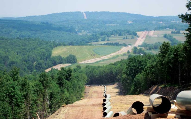
The midstream industry has implemented data models to store and analyze the information needed to monitor and maintain the millions of miles of petroleum pipeline networks throughout the US. Information about assets that is maintained in models includes construction details, inspection results, integrity management, regulatory compliance, and risk analysis, as well as operational data.
According to Craig Hawkins, a GISP and the manager of Asset Information and GIS at Crestwood, midstream companies store data in very similar ways. Many data models used by midstream companies are cooperatively developed by the pipeline industry with the support and direction of organizations like the Pipeline Open Data Standard (PODS) Association, which has been developing these models for more than 20 years. Members of the association contribute to the development of the data models and leverage the latest and greatest model available.
The models use a linear referencing system (LRS), which stores the geographic location of a pipeline asset by its relative position along a measured linear distance, rather than determining the x,y coordinates of each asset as other models do. LRS specifies features (or assets) along linear route sections between defined starting and ending points. It is commonly used by engineers because of its precision. To perform its linear measurements, LRS references the centerline axis of a pipe, which is a calculated line that runs longitudinally through the midpoint of the pipe’s diameter.
In addition to being more precise, LRS is also more cost-effective for data maintenance procedures. When a change is made to a section of the pipeline, the affected section is recalculated by the software and stored in its related data model, maintaining the referential integrity of the pipeline. Many pipeline companies use ArcGIS in their operations. Models developed by PODS have provided links to the ArcGIS geodatabase for the past 10 years.
After Hawkins joined Crestwood in 2016, one of his first tasks was determining how to consolidate the company’s different data models into a single system. Crestwood had a PODS relational data model running on Microsoft SQL Server, an ArcGIS Pipeline Data Model (APDM) from a previous acquisition, and other legacy data stored in ArcSDE. It was clear to Hawkins that these disparate data sources should be migrated into a single “source-of-truth” database so the company could manage its data and perform analyses more effectively.
There were many options available, but Crestwood decided to implement the extended version of PODS Next Gen, which is supported by the ArcGIS Pipeline Referencing location model and provides GIS capabilities that are useful in performing linear referencing data management.
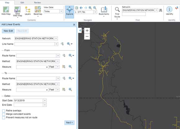
“Migrating multiple databases at the same time can be complex, but ultimately, we were able to generate one LRS network to get a single, comprehensive view of our pipeline network,” said Hawkins. “The APR [ArcGIS Pipeline Referencing] tools allow us to manage the centerline geometry and data maintenance on a daily basis, which is key to our work.” If a pipeline is rerouted, the centerline and any associated data can be edited.
Hawkins noted that Crestwood is continually seeking ways to leverage new technology in the pipeline industry. In addition to streamlining data management best practices, the company is looking at better ways to leverage geospatial technology, reporting, systems integration, and big data infrastructure.
“Because we collect large volumes of data, we are considering making better use of ArcGIS Data Store, along with Elasticsearch, a distributed search and analytics engine,” said Hawkins. “This would allow us to expand our commercial efforts by allowing us to quickly tap into a variety of databases and run different analytics to help with business development and the decision-making process.”
Crestwood is also exploring the use of Insights for ArcGIS to do more spatial and statistical analyses of its operations for scheduled procedures, such as inspections, maintenance, risk assessment, environmental impact, regulatory requirements, and health and safety compliance. That information could be presented in dashboards for review by management.
“These are just a few of the areas that we will be exploring in the future to help us better maintain our assets and expand our business. I think that geospatial technology holds tremendous potential for our industry because it can help us improve our efficiencies through the use of location-based intelligence, which is already a strategic part of our information infrastructure,” said Hawkins.
About the author