With the fire hose of imagery that’s streaming daily from a variety of sensors, the need for using artificial intelligence (AI) to automate feature extraction is only increasing.
The ability to train more than a dozen deep learning models on geospatial datasets and derive information products has been available using the ArcGIS API for Python or ArcGIS Pro, and users can scale up processing using ArcGIS Image Server.
Esri is taking AI to the next level with ready-to-use geospatial AI models in the ArcGIS Living Atlas of the World. Initially, three models have been made available. Two of the models use satellite imagery. One model extracts building footprints and the other performs land-cover classification. A third model classifies points representing trees in point cloud datasets.
These newly released models have been pretrained by Esri on huge volumes of data and can be readily used—with no training required—to automate the tedious task of digitizing and extracting geographic features from satellite imagery and point cloud datasets. Not only do these models bring the power of AI and deep learning to the Esri user community, but they are also accessible to anyone with an ArcGIS Online subscription at no additional cost.
Using the Models
Using these models is simple. You can use geoprocessing tools, such as the Detect Objects Using Deep Learning tool in ArcGIS Pro, with the imagery models. Just point the tool to the imagery and the downloaded model. That’s it. Deep learning has never been this easy. Though it’s not necessary, a graphics processing unit (GPU) can help speed things up. With ArcGIS Enterprise, you can scale up inferencing using ArcGIS Image Server.
In the future, you will be able to consume the model directly with ArcGIS Image for ArcGIS Online, and run it against your imagery that’s uploaded to ArcGIS Online. The 3D Basemaps solution is also being enhanced to use the tree point classification model and create realistic 3D tree models from raw point clouds.
How to Benefit from Deep Learning Models
It probably goes without saying that manually extracting features from imagery—like digitizing footprints or generating land cover maps—is time-consuming. Deep learning automates this process and significantly minimizes the manual interaction needed. However, training your own deep learning model can be complicated. It requires a lot of data and extensive computing resources as well as the knowledge of how deep learning works.
With ready-to-use models, you no longer have to invest time and energy either manually extracting features or training your own deep learning models. These ready-to-use models have been trained on data from a variety of geographies and work well. As you receive new imagery, you can extract features at the click of a button and produce GIS layers for mapping, visualization, and analysis.
Ready-to-Use Models
The three deep learning models available from ArcGIS Online as deep learning packages (DLPKs) can be used with ArcGIS Pro, ArcGIS Image Server, and ArcGIS API for Python.
The Building Footprint Extraction—USA model is used to extract building footprints from high-resolution satellite imagery. While it is designed for the contiguous United States, it performs fairly well in other parts of the globe. Building footprint layers are useful for creating basemaps. They are also used in analysis workflows for urban planning and development, insurance, taxation, change detection, and infrastructure planning. Learn more about the Building Footprint Extraction—USA model from this story map.
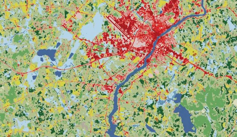
The Land Cover Classification (Landsat 8) model uses Landsat 8 imagery to create land-cover products that have the same classes as the National Land Cover Database (NLCD). The resultant land-cover maps are useful for urban planning, resource management, change detection, and agriculture.
This generic model has been trained on NLCD 2016 with the same Landsat 8 scenes that were used to produce the database. Because land-cover classification is complex, it is hard to capture using traditional means. Deep learning models can learn these complex semantics and give superior results.
The Tree Point Classification model can be used to classify points representing trees in point cloud datasets. Classifying tree points is useful for creating high-quality 3D basemaps, urban plans, and forestry workflows.
Try These Models for Yourself
The deep learning tools in ArcGIS have dependencies that require downloading and installing Python site packages. Get the installer to add these packages from the Esri GitHub repo. Download the DLPKs from the ArcGIS Living Atlas of the World. Learn more about using these models from the Imagery and Remote Sensing community page on Esri Community.
About the authors

Vinay Viswambharan