In the fall semester of 2021 at Kennesaw State University, five undergraduate students—in conjunction with the US State Department’s DipLab Demo Day—embarked on a unique research opportunity. The student team, with faculty lead professor Uli Ingram, accepted a challenging assignment: to find ideal locations for new United States embassies in cities all over the world.
Geospatial sciences students Andrew Bailey, Alaina Ellis, Cheyenne Feltman, and Grace Shirley and architecture student MaKenna Chambers made up the team that participated in the US Department of State program. It is a public-private partnership that taps into the efforts and expertise of students and faculty at colleges and universities across the United States in research related to foreign policy challenges.
The students were provided with a list of parameters for ideal embassy sites. They were to consider proximity to favorable locations, such as host government offices, other foreign embassies, businesses and cultural centers, and public transportation. They also had to consider maintaining distance from unfavorable features such as potential security threats, natural hazard zones, and areas with high crime rates. The goal was to deliver strengths, weaknesses, opportunities, and threats (SWOT) analyses for each assigned city by the end of the semester.
Team members found the data searching phase, often hampered by language barriers and regions with limited publicly available spatial data, to be the most challenging. Once the required data was collected, they utilized ModelBuilder and the ArcGIS Spatial Analyst extension of ArcGIS Pro to produce weighted suitability overlays that considered both the inputs and the relative importance of each. The resultant focus areas considerably narrowed the scope for site searches, even identifying promising individual parcels in some of the more data-rich cities.
Prior to this project, site acquisition staff in the State Department’s Bureau of Overseas Buildings Operations (OBO) often used qualitative measures and reports from real estate brokers to find future embassy locations. This project provided a proof of concept for the implementation of a more quantitative approach to site acquisitions with geospatial analysis to supplement the OBO’s current system.
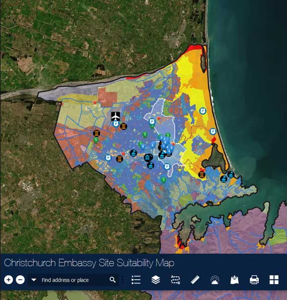
After a full semester of data collection and analysis, weekly meetings with Ingram, and biweekly progress meetings with OBO contractors Sunny Peterson and Calvin Clessas, the students presented their final reports and findings to the OBO in December 2021. Ultimately, the results were delivered in the form of ArcGIS Pro project files and geodatabases, stand-alone maps, and interactive web applications tailored to each city.
In February 2022, the team reunited to present its research once more at the Diplomacy Lab Demo Day, representing one of only three teams in the nation chosen to present to State Department representatives and project partners. While Diplomacy Lab projects have historically focused on more traditional subjects in foreign policy, the inclusion and support of GIS research demonstrated the vast spectrum of opportunities in the fields of both foreign policy and geospatial science.
“You are literally the future of foreign policy; you are the future of the Department of State,” said Thomas Debass, managing director for the Office of Global Partnerships, while addressing the presenting student research teams, “American leadership can only be maintained if students like you continue to engage with us, and hopefully you can join our ranks.”
After the success of the first round of the project, Ingram and Kennesaw State University have ramped up their involvement in the Diplomacy Lab program. The project is continuing during the spring 2022 semester, this time with two additional Directed Applied Research students and 20 Advanced GIS students analyzing a new list of cities around the world.
For more information, please contact Uli Ingram at
uingram@kennesaw.edu.
About the authors

Uli Ingram