In spite of all the changes the world has experienced over the past year, one thing has remained steady: GIS is making a difference in so many of the things we do. Some might even argue that GIS is more important now than ever before, given how COVID-19 has raised awareness around the globe of how important geospatial technology is for problem-solving and decision-making.
GIS Day was officially commemorated on November 18, 2020. Celebrations were not only extra cautious, they were also extra special. Most events were held online, which allowed people from all over the world to attend presentations, workshops, interactive meetups, and other virtual functions hosted by government agencies, libraries, schools, universities, nonprofit organizations, and private companies. The hosts of each registered event used ArcGIS Hub to organize and present their GIS Day content and engage, serve, and collaborate with their communities.
“You just can’t stop the enthusiasm and quest to share GIS knowledge, even during a pandemic,” said Maria Jordan, Esri’s product marketer for ArcGIS Hub. “Whether celebrating as part of a city, county, university, or private business, GIS Day hosts stepped their creativity up a notch this year to plan virtual events, record YouTube videos, and broadcast radio show programs to reach their audiences.”
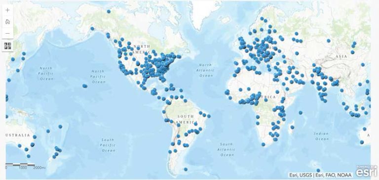
More than 1,200 GIS Day events were registered at gisday.com, putting them on the GIS Day map. And most of these activities were open to the public. Just a few of the events that were held in 2020 are included here.
At the University of Salzburg in Austria, the geoinformatics program held a GIS Day event to teach people what the technology is and why it matters. Part of the fun for attendees was exploring the nine most beautiful hidden places in Austria, using maps and map narratives built with ArcGIS StoryMaps stories.
Government agency Land Information New Zealand sponsored a virtual, three-day field trip for schools that showed students how to use maps to safely hike the outdoors. Nepal’s Federation of Community Forestry Users led attendees through a demonstration and discussion of its critical forest work.
GIS practitioners from a range of professions presented their work to attendees at an event hosted by Central Connecticut State University and the Connecticut GIS Network. Other participants submitted map posters, ArcGIS StoryMaps stories, and other geospatial apps to a gallery. The university also held a rousing game of GeoJeopardy.
The National Geospatial Technology Center of Excellence (GeoTech Center) organized six hours of events—in both English and Spanish—that included talks, geogames, mapping activities, and a map contest and gallery. GeoTech Center promotes the use and teaching of GIS in community and technical colleges.
The Udzungwa Ecological Monitoring Centre in Tanzania taught other GIS Day participants about tropical biodiversity through its GIS Day event.
Geospatial Libya Consulting in Misratah, Libya, held a discussion on spatial data infrastructure. The School of Geography at the University of Costa Rica demonstrated what faculty and students are doing with GIS in their instruction and research.
In addition to these events hosted around the world, the GIS Day website served up some new, on-demand content to help everyone celebrate the technology, from the comfort of their own homes. Videos, articles, and podcasts posted on the website spotlighted GIS influencers who are using the technology to do important work such as building inclusive workforces, designing landscapes with climate change in mind, and responding to devastating wildfires.
Esri also released a new GIS Day mobile app, available for download from the Google Play and Apple app stores, that was designed to help GIS professionals share the technology with their colleagues, students, and community members through games and map exploration activities. The idea was to let people experience GIS firsthand on their own devices.
Each host who registered an event on the GIS Day website received five ArcGIS for Personal Use licenses. The hosts had full discretion over how to distribute the licenses. Some held contests and lotteries, others gave them out at networking activities, and still others doled them out as gifts to presenters or donations to nonprofits. The point was to help hosts further the use of GIS within their communities beyond GIS Day.
Around the world, people use GIS Day as a way to help others discover GIS, share their accomplishments, and inspire their peers with the infinite ways that geospatial technology can be used. The next GIS Day will be November 17, 2021, so plan to join in.

Government agency Land Information New Zealand sponsored a virtual, three-day field trip for schools that showed students how to use maps to safely hike the outdoors. Nepal’s Federation of Community Forestry Users led attendees through a demonstration and discussion of its critical forest work.
GIS practitioners from a range of professions presented their work to attendees at an event hosted by Central Connecticut State University and the Connecticut GIS Network. Other participants submitted map posters, ArcGIS StoryMaps stories, and other geospatial apps to a gallery. The university also held a rousing game of GeoJeopardy.
The National Geospatial Technology Center of Excellence (GeoTech Center) organized six hours of events—in both English and Spanish—that included talks, geogames, mapping activities, and a map contest and gallery. GeoTech Center promotes the use and teaching of GIS in community and technical colleges.
The Udzungwa Ecological Monitoring Centre in Tanzania taught other GIS Day participants about tropical biodiversity through its GIS Day event.
Geospatial Libya Consulting in Misratah, Libya, held a discussion on spatial data infrastructure. The School of Geography at the University of Costa Rica demonstrated what faculty and students are doing with GIS in their instruction and research.
In addition to these events hosted around the world, the GIS Day website served up some new, on-demand content to help everyone celebrate the technology, from the comfort of their own homes. Videos, articles, and podcasts posted on the website spotlighted GIS influencers who are using the technology to do important work such as building inclusive workforces, designing landscapes with climate change in mind, and responding to devastating wildfires.
Esri also released a new GIS Day mobile app, available for download from the Google Play and Apple app stores, that was designed to help GIS professionals share the technology with their colleagues, students, and community members through games and map exploration activities. The idea was to let people experience GIS firsthand on their own devices.
Each host who registered an event on the GIS Day website received five ArcGIS for Personal Use licenses. The hosts had full discretion over how to distribute the licenses. Some held contests and lotteries, others gave them out at networking activities, and still others doled them out as gifts to presenters or donations to nonprofits. The point was to help hosts further the use of GIS within their communities beyond GIS Day.
Around the world, people use GIS Day as a way to help others discover GIS, share their accomplishments, and inspire their peers with the infinite ways that geospatial technology can be used.
The next GIS Day will be November 17, 2021, so plan to join in.


