Almost every day that Lauren Sinclair teaches one of her middle school GIS design classes, she gets asked by a student if the data they are working with is real. Is this information about real people from the real census?
These students are amazed and impressed by a fundamental fact about GIS that can be easy for the rest of us to forget. Everything else in their education is hypothetical, but in GIS class, they work with real data from the real world. They recognize why that matters: it means they can make decisions that have a real impact.

If students can follow instructions, they can do GIS, so teachers can guide them without being GIS experts.
A middle school teacher who loves enabling kids to make great maps, Sinclair teaches sixth grade and eighth grade GIS design classes at the French International School in Portland, Oregon. In addition to GIS design, she teaches woodworking and environmental science. A National Geographic Educator, she is constantly brainstorming new ways for middle school students everywhere to unlock the power of GIS. She is also a Where’s Waldo aficionado and a Carmen Sandiego lookalike.
Her teaching methods are varied. She starts sixth graders with concrete exercises, such as building topography contours with modeling compound. This year her eighth grade students are working on the Learn ArcGIS lesson “Map Voter Data to Plan Your Campaign” and are participating in the Going Places with Spatial Analysis massive open online course (MOOC). Both are offered by Esri at no cost. Students at either level finish the course by creating their own maps. Sixth graders must map something on their school campus, while eighth graders are given free rein to map anything they choose.
Instead of starting each class with a description of what the students will do that day, Sinclair begins with a discussion on why they should care about the day’s assignment. Middle school kids may be adopting a “Who cares?” attitude, but that’s not necessarily because they don’t care. They just want some justification for why they should. Sinclair’s GIS classes this year have focused on political participation, specifically redistricting and gerrymandering. Students are passionate about these topics and want to make maps that propose fairer solutions.

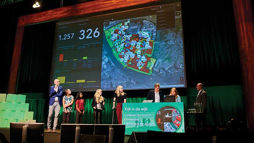
Sinclair wants students to know that it’s empowering to use real data in a real way. This year, her students participated in a mapathon for the Missing Maps program. Missing Maps, an open, collaborative project, helps map areas where humanitarian organizations are trying to help vulnerable people. As soon as Sinclair’s students understood they would be contributing to maps that would be used by real people in humanitarian organizations on the other side of the world, they couldn’t wait to get started.
Sinclair also volunteers to teach other classes using GeoInquiries, short, standards-based inquiry activities for teaching map-based content found in commonly used textbooks. GeoInquiries are available from Esri for free. The other teacher logs an hour of professional development time observing as Sinclair guides their students through map-based learning and is introduced to a powerful teaching tool at the same time.
Sinclair wants other teachers to know that they don’t need to be good at GIS. They don’t have to take time to learn this new technology because GeoInquiries are easy for both students and teachers to use. If students can follow instructions, they can do GIS, so teachers can guide them without being GIS experts.
Although she studied GIS at Portland State University, it was back before there were readily available resources for K–12 GIS education, so Sinclair got started using GIS in teaching by enrolling in the GeoMentors program, which matched her with local GIS experts. Next, she attended the Esri User Conference, where she met like-minded educators who became a valuable peer group. Now she’s ready to help others. She encourages teachers curious about teaching with GIS to reach out to her via Twitter @MrsSinclairMaps or email.