Intrapreneurship
Maybe you’ve heard this word—maybe not. It simply means having a system that allows employees to act as entrepreneurs within their organization. This doesn’t have to be a formal thing. Anyone can be an intrapreneur. They’re usually self-motivated, action-oriented innovators who take the initiative within the organization. A lot of GIS professionals are intrapreneurs.
Infrastructure is the basic structure needed to operate an organization. For this discussion, we’ll focus on geospatial infrastructure. Geospatial infrastructure is technology, data, and services delivered in modern architected technology. It enables organizations at all levels to share, collaborate, interconnect, and benefit from the capabilities of GIS.
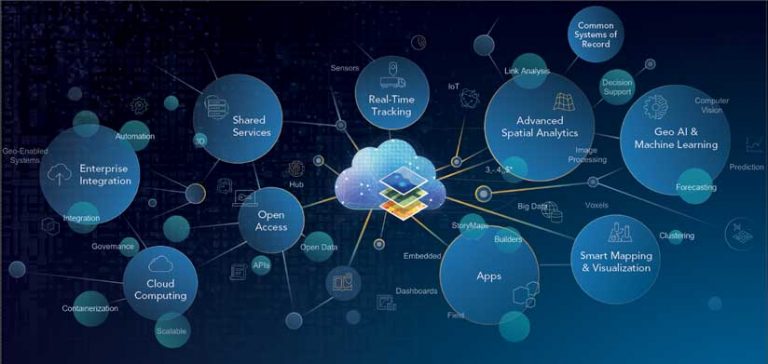
Geospatial infrastructure enables intrapreneurs by delivering data, app builders, configurable dashboards, analytical tools, and a broad range of capabilities designed to address your organizations’ workflows and help it meet challenges and capitalize on opportunities. This infrastructure enables the integration of every type of data and format. It makes the organization’s data as well as external datasets available in a single, comprehensive view that enables advanced analysis, visualization, and sharing. This improves collaboration, eliminates data duplication, and redundant workflows, and adds capabilities to all levels of an organization.
Back in the old days of custom code, capabilities and workflows had to be built for each organization’s needs. There really wasn’t a choice. If you wanted a technology solution, you needed to build it yourself. That came with a lot of baggage, particularly as related to the infrastructure needed to support custom software—system upgrades, personnel, documentation, and training—all with costly long-term commitments.
ArcGIS Solutions configurations are now part of the geospatial infrastructure. These solutions furnish maps, apps, hub sites, dashboards, and analytical tools configured to meet the common requirements for specific types of organizations. ArcGIS Solutions for Local Government are focused on planning, land records, elections, transportation, and emergency management. There are solutions for water, electric, gas, telecommunications, business, conservation, and defense and intelligence.
There are also solutions to help organizations respond to specific challenges. There are solutions for the coronavirus pandemic that assist with site safety, business continuity, health screening, testing sites, and reporting metrics. There is a solution set of maps and apps to help provide insight into patterns of inequality and bring communities together around a common understanding and awareness of social inequities.
Choose solutions that fit the needs of your organization and configure them yourself. Most solutions are supported and being actively developed to evolve with the changing needs of organizations. These solutions include a plethora of datasets found in the ArcGIS Living Atlas of the World including basemaps, demographics, imagery, administrative boundaries, employment, income, and neighborhoods. It also includes live data feeds such as weather and traffic.
These solutions make it easy to be an intrapreneur. You and others in your organization can easily create efficiencies, reduce redundancies, and add analytical capabilities with dashboards, web maps, and apps. You can configure their look and feel to match your organization’s requirements and branding. You still get the same satisfaction of a do-it-yourself project without the necessity of creating custom software with long-term commitments for support, upgrades, and training.
Geospatial infrastructure empowers everyone to be an intrapreneur. We all want to do new things, use new technology, and improve our work. Configurable ArcGIS Solutions, ArcGIS Hub, ArcGIS Dashboards, and ArcGIS Field Apps and workflows make this technology accessible and useful to everyone. It can make us all intrapreneurs.