Keeping data synchronized between a GIS and an asset management system is always challenging but of great value to business users. Loudoun Water implemented a cloud-based solution designed to simplify the challenges of Esri-SAP integration and optimized its operations.
Loudoun Water provides drinking water, wastewater, and reclaimed water services to over 80,000 homes and businesses in Loudoun County, Virginia, a Washington, DC, exurban area. For decades, Loudoun Water has used Esri GIS as the system of record for linear assets, such as pipes, maintenance holes, and hydrants, and synchronized them with an asset management solution to support maintenance, operations, and engineering activities.
In 2014, Loudoun Water implemented SAP software to run most aspects of the business including asset and maintenance management. At that time, only a handful of organizations in the world had achieved Esri-SAP technology integration in GEO.e. THe GEO.e solution ran inside SAP software and included both a map for visualizing/interacting with objects and a custom synchronization toolset that maintained the data integrity between the two systems.
Implementing GEO.e at Loudoun Water was a big success and added tremendous value to business users who wanted one version of reality, knowing that objects they saw in the GIS were the same objects they worked with in SAP and vice versa. With this success came additional requests to add other synchronized objects and attributes and improve the mapping capability.
However, making modifications to GEO.e proved to be difficult and costly with few technical resources to draw on. The complex code base also made routine incident management a challenge, and there were performance limitations when working with a large dataset. Furthermore, Loudoun Water plans to begin using SAP S/4HANA in the future. This required changing GEO.e, which presented a challenge to Loudoun Water, so alternatives were investigated.
Loudoun Water has a cloud-first policy for technology. The company moved its Esri and SAP solutions to separate Microsoft Azure cloud instances several years ago. Living with GEO.e emphasized that proven commercial off-the-shelf software was preferable to a custom one-off solution. Keeping this in mind, other water industry organizations were canvassed to identify a replacement for GEO.e.
Spatialitics LLC was identified by Loudoun Water as the perfect fit since it offered a cloud-based solution designed to simplify the Esri-SAP integration challenge. The solution comes in two parts: a map called Spatialitics Asset Mapper (SAM) and a robust synchronization framework called Unity Engine.
A fully owned subsidiary of CyberTech, Spatialitics specializes in providing spatial analytics products and platforms using a cloud-based approach to digitalization. The company covers a wide range of industries, including health, public safety, and utilities.

After a thorough requirements-gathering phase, the project team from Loudoun Water and Spatialitics successfully constructed an architecture that securely connects the Esri, SAP, and Spatialitics cloud environments. Cybersecurity is a top priority for Loudoun Water, and the Spatialitics solution was ready to be configured to unique and demanding specifications. Loudoun Water also has an Esri enterprise agreement, which meant that software licensing was not a factor as the team architected and tweaked the optimal design.
Spatialitics hosts configuration data (not the underlying business data) and enables real-time communication among the three environments. Because Unity Engine is SAP certified, Loudoun Water can be confident that the future move to S/4HANA won’t be complicated by the Esri integration.
Each part of the solution meets a different business need. Front office end users employ SAM, and back office technologists, who are responsible for managing synchronization, use Unity Engine. In the front office, daily users from across the business solve multiple problems. For example, the team responsible for managing meters has adopted SAM, as its mobile work order solution because it is real-time technology and easy to use to complete work orders.
The asset management team members like SAM because they can quickly access work order history while working directly in the map with many objects. Maintenance planners must use a map to create work orders. SAM includes functionality to do this individually or in bulk, which saves a lot of time. Customer service representatives can be talking with a customer while getting a real-time view of open work orders nearby, informing them of what’s happening in this customer’s neighborhood.
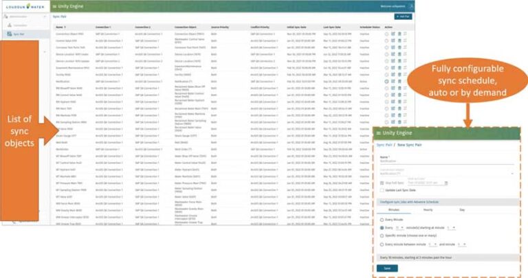
In the back office, the technologists responsible for managing the synchronization are thrilled with Unity Engine and have realized multiple benefits from its use. The easy-to-use interface makes it simple to manage the process and understand how objects and attributes in one system relate objects and attributes to the other system.
The synchronization can be scheduled or run on demand. All activities are logged for auditing of synchronization performance, and any problems are easy to spot. Unity Engine includes transformation capabilities that make it possible to automatically perform calculations each time synchronization runs. Since the solution is hosted by Spatialitics, which is responsible for routine operation and maintenance, Loudoun Water staff can focus on higher-value activities such as extending the synchronization and map functionality in the direction that the business leads.
“As the technology owner, I’m pleased that the Spatialitics solution meets our business needs, satisfies our strict cybersecurity requirements, is easy for us to operate, and is S/4HANA ready,” said Mike Beardslee, managing director of technology services for Loudoun Water.