Over the last few years, the methods used to gather, process, and display the nation’s geological data have changed significantly. GIS is at the forefront of these developments, leading to a rethinking and reimagining of how state-level geological surveying agencies conduct their work.
The major impetus for these changes is GeMS—or Geologic Mapping Schema—a standard developed by the US Geological Survey (USGS) National Cooperative Geologic Mapping Program (NCGMP). [A schema is the formal definition of a dataset’s structure, which includes feature types, permitted geometries, user-defined attributes, and other rules that define or restrict its content.] USGS has been developing GeMS over the last two decades. GeMS is optimized for ArcGIS products “in order to adhere to USGS policy, and because this is the GIS most commonly used in the USGS, in the state geological surveys, and in the larger community,” according to the agency’s publication describing GeMS.
Precious GeMS
USGS now uses GeMS for nearly all the geologic mapping products it creates, and state geological surveys are also beginning to adopt it. “Across the board, all mapping is now being created in GeMS, or at least working toward it,” said Jennifer Athey, a geologist with the Alaska Division of Geological & Geophysical Surveys, which provided input to USGS during the development of GeMS.
Vicki Voigt, a geologist with the Missouri Geological Survey, said that initial qualms about GeMS within the geologic mapping community were quickly allayed by how well it worked.
“USGS has implemented GeMS slowly, which has made the schema easier to adopt,” she said. “After having a chance to acclimate to GeMS, we’ve realized that it’s pretty straightforward and a practical approach to archiving geologic information.”
Connecting the Dots
By making it easier to integrate data from state surveys, GeMS will help NCGMP fulfill a primary objective, the construction of a complete bedrock and surficial map of the United States.
At the same time, state geological surveys have adopted GeMS as a way to help complete their own state maps. Athey said that GeMS is helping her office make great progress in its “pie in the sky goal” of creating a 1:100,000-scale geologic map of Alaska. Voigt detailed how one of her colleagues at the agency has begun to implement the 1:500,000-scale geologic map of Missouri into GeMS using the new schema.
“It’s an incredible effort,” Voigt said. The map contains hundreds of bedrock unit polygons and polyline feature structures, and the GeMS schema is very particular, but Voigt has been able to complete it with very few headaches.
“The GeMS idea came around at the right time for us. We were inefficient and didn’t have a standard of our own, so we were in a really good place to adopt it,” said Athey. “Knowing we were going to be producing our deliverables for mapping in this new standard helped make us ready for it.”
A Streamlined Process
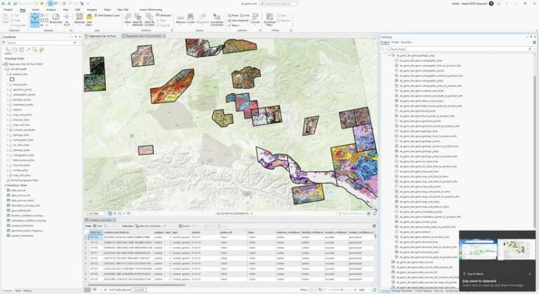
Using a modified form of GeMS optimized for Alaska, the agency has developed a unified way to apply the standard to all the mapping products it produces from a variety of sources. These sources include old paper maps that require digitization, cartographic-centric data that requires conversion into GeMS, and products compiled from various data sources.
“Our basic process when we produce a product—and this includes conversion products—is that we go to the field to collect data and we use databases there, typically using [ArcGIS] Field Maps or [ArcGIS] Collector,” said Michael Hendricks, a GIS analyst with the Alaskan agency. “We’ll be in the field for three or more weeks with no internet access at all, so we actually stand up [ArcGIS] Enterprise portals on small devices and use them in the field offline, which is not for the faint of heart, let me tell you.”
Back in the office, once a map is created, the data is reviewed using ArcGIS Data Reviewer, Python scripts, and models. With that completed, metadata is added. The data is also converted from the local GeMS to the main version, and the map is then packaged for publication and delivery to USGS.
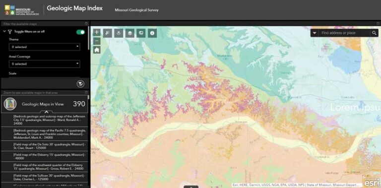
Voigt said the Missouri agency is in the process of developing workflows that will allow raw data from the field to be incorporated directly into GeMS. It plans to have these workflows in place by the end of the year.
“It’s a learning effort, but I think this process is going to be simple and straightforward,” she said. “When you’re archiving the geologic information of a small-scale 7 1/2-minute quadrangle, you’re looking at maybe 12 bedrock polygons and few polylines, so it’s simple to incorporate them into the [GeMS] database.”
Improved Workflows
Retooling geological mapping procedures around GeMS creates a smoother internal workflow. As Voigt pointed out, GeMS databases are part of the deliverables for all products the office creates for USGS. “GeMS sets us up to automate our geologic mapping process from the beginning, so there’s no back end anymore when putting the databases together,” she explained. “It’s almost like we’re getting double the work done.”
Alaska Division of Geological & Geophysical Surveys has also seen increased productivity. “I think we’re moving four times as much data through the process as we used to,” Athey said.
Hendricks agreed. “In the past, one of the big bottlenecks has always been metadata,” he said. “And every database, even if it was in the same schema, people would implement it differently. What used to take a week, he added, can now be accomplished before lunch.
Internal and External Benefits
Streamlined workflows yield benefits both in and out of the office. For internal use, these standardized databases have the advantage of making information more findable and salvageable.
“We are a repository of so much information, and historically it’s been taken down on paper and put in a filing cabinet somewhere,” Voigt said. “It’s been a huge effort to make sure all the information has been captured and remains usable. We have geologists who make very important decisions every day, and it’s essential that they have all the information they need.”
The advantages extend to everyone who requires solid geological maps and data. “What it really comes down to is, how are we helping the taxpayers by providing them with the best products in a timely manner?” said Jerry Prewett, deputy director of the Missouri Geological Survey. “This is standard information that a lot of people need.”
Those who rely on authoritative Alaska geological mapping data range from people in industry and academia to “people who are building a house and want to know what’s underneath it,” according to Athey. “And now we can make this data available to them so much faster.”