It’s no secret that the popularity of drones, for both commercial applications and recreational use, has exploded over the past few years. In the US alone, drone registrations currently stand at nearly 1.5 million units according to the Federal Aviation Administration (FAA).
How well are local communities prepared to handle this new kind of traffic?
State and local governments work diligently to ensure the safest possible conditions for vehicular traffic on the ground. With the growth of drone activity, a new system of traffic control is needed in the skies above. Although entities, such as the FAA in the United States, have long had protocols for maximizing safety for manned aircraft, how will unmanned aircraft, or drones, be managed?
Working Together
The FAA has adopted a collaborative approach for sharing local airspace between government and private industry with the introduction of the UAS Data Exchange, an umbrella organization. The Low Altitude Authorization and Notification Capability (LAANC) is the first of several partnerships UAS Data Exchange will support.
LAANC is intended to directly support the integration of unmanned aircraft system (UAS) vehicles into US airspace. Other countries have adopted similar initiatives, such as the Swiss U-space or Drone Alliance Europe. In each case, regulators want to support technology innovation while still providing air traffic professionals with information on where and when drones are operating. Although much work remains to be done, early integrations have strengthened these programs and are paving the way for continued growth.
With growth in mind, safety remains the priority for federal regulators when considering drone integration. Despite education and technological solutions, drones are still sometimes found in places where they do not belong. A recent study by Embry-Riddle Aeronautical University that was published in the International Journal of Aviation, Aeronautics, and Aerospace in 2018 looked at drone flights over a two-week period around Daytona Beach International Airport. The results showed that 21 percent of flights exceeded the recommended maximum altitude for the area in which they were operating, creating an inherent airborne risk.
However, with so much focus on what’s going on in the air, the stakeholder with a more down-to-earth perspective remains underutilized: local government. GIS data, already being maintained by a community, can be the source for current, on-the-ground information used to enforce drone regulations within that community and pave the way for constructing a new UAS infrastructure.
Community Safety and Risk
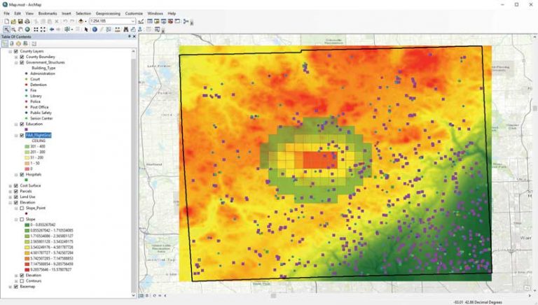
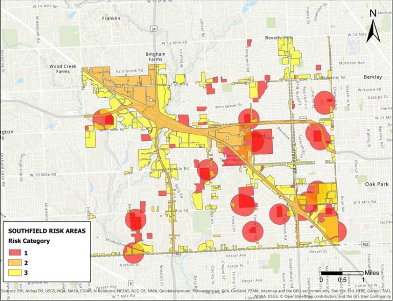
What would happen if a 20-pound drone, plus payload, crash-landed in your community? The wealth of GIS information generated by cities can help answer questions like this one. Land use, land cover, slope, building footprints, street centerlines, school locations, and other GIS data that cities maintain can be used for drone risk analysis.
Some cities utilize computer vision (the ability for computers to see) or remote sensing processes to conduct urban analysis projects. For example, using artifical intelligence (AI) and GIS, workflows can be developed for calculating the number of vehicles in a parking lot to estimate how many people are in the area at a specific time, which could inform risk analysis for operating drones over specific locations.
As drone egress and ingress locations proliferate, GIS will help community officials place and approve individual or common landing hot spots. Regulating these locations may rely on a process of permitting that incorporates automated approval/denial decisions based on risk data, visual inspection, and operation verification to help satisfy safety requirements. GIS already plays an important role in existing permitting workflows, and the progression into UAS infrastructure will be a natural extension of this process for many communities.
Drones and Raster Analytics
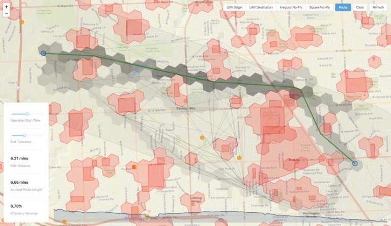
Perhaps the gold standard many drone technology evangelists are working toward is the operation of drones autonomously or remotely from the pilot’s location. Known as Beyond Visual Line of Sight (BVLOS), these modes of drone operation are not allowed in most regulated environments. A better understanding of the types of paths a drone would take if left unmonitored is required before these restrictions will be lifted.
By most measures, an “as the crow flies” path is usually the optimal one for any given drone operation. This is especially true with limited onboard battery storage. Dynamic variables, such as weather, can make total battery life unpredictable. Unfortunately, a straight-line path is not always the safest path, and safety must be the controlling factor for mission planning.
Utilizing community data, raster analytics can be put to work to generate BVLOS risk analysis for drones. Part of this analysis is deriving a cost surface. By chaining together raster functions (image processing algorithms), a data product can be derived that represents the cumulative risk for operating drones over specific geographies based on datasets provided by local government.
A cost surface empowers decision- makers and automated systems to calculate the optimal travel path over the length of the planned mission. Given any origin and destination, this path will have the least accumulated risk. This capability will enable use cases such as point-to-point delivery, remote inspections, and “drone in a box” (i.e., drones launching autonomously from remote charging stations).
GIS Supporting the UTM Ecosystem
In addition to static risk analysis, many countries are also developing Unmanned Traffic Management (UTM) ecosystems that tightly integrate existing manned aircraft services with unmanned drone operations. GIS would be key to keeping these types of operations location aware.
For example, imagine that a delivery drone flying a preprogrammed route happens to cross paths with a medical helicopter airlifting someone out of an area. With a functioning UTM system, the drone and the helicopter would communicate automatically and avoid a collision. Alternatively, in this example, the drone would be flying in an established drone corridor, and the helicopter pilot would allow for that in formulating the flight plan.
In a UTM ecosystem, emergency managers in communities will use GIS tools to grant authorizations to drone service providers, issue notifications to drone operations regarding air and ground activities relevant to their safe operation, and share this information with multijurisdictional stakeholders.
Aside from safety, urban designers are often concerned about sound levels in neighborhoods. Mechanical buzzing doesn’t fit with anyone’s idea of a pleasant community. GIS can be incorporated into applications that track the number of flights intersecting subsections of a city and “deactivate” airspace for a predetermined cooldown period. In the future, urban airspace designers will construct drone corridors using a combination of risk and noise pollution factors.
Conclusion
As technology advancements push innovation into the skies, cities can lean on GIS data already being generated by local governments to prepare for and benefit from a Jetsonian future rather than reacting to issues arising from unregulated drone activity in local airspace.
Airspace Link, a certified FAA UAS Service Supplier (USS) and an Esri partner, is building solutions that incorporate existing geospatial data gathered by communities for the implementation of sustainable drone infrastructure that meets the needs of state and local government. By collecting, analyzing, and delivering the most relevant community data to the drone industry, Airspace Link helps maximize safety from both ground- and air-based hazards.
For more information, contact Daniel Bradshaw at daniel.bradshaw@airspacelink or visit airspacelink.com
About the author