In 2015, Mississippi State University (MSU), developed a focused training program to identify and teach emerging issues in computerized agriculture. The MSU College of Agriculture and Life Sciences (CALS) offers a Precision Agriculture Certificate, a cross-departmental certificate, designed to train students in precision agriculture technologies that complement multiple majors taught across CALS departments.
MSU is in Starkville, an agricultural-commercial-industrial city of nearly 24,000 located in northeastern Mississippi. Founded as the Agricultural and Mechanical College of the State of Mississippi in 1878, it became Mississippi State College in 1932. It was fully accredited as a university in 1958 and has evolved into a comprehensive, doctoral degree-granting institution with a nationally and internationally diverse student body.
University researchers and instructional faculty are assisted by an effective research administration that has placed MSU among the top 100 universities in the nation in research and development in the sciences and engineering. The Mississippi Agricultural and Forestry Experiment Station operates 16 branch stations throughout the state and conducts research in a variety of areas as well as assists in the university’s teaching and service functions. The MSU Extension Service offers programs and services to state residents through campus and county offices and personnel.
GIS is taught in several different departments at MSU including Geosciences, Forestry and Wildlife, Landscape Architecture, Agriculture Bioengineering, and Plant and Soil Sciences. The MSU Precision Agriculture Program was developed from private foundation donations to establish an interdisciplinary faculty team addressing emerging issues in computer-based agriculture. Its curriculum is supported by generous gifts from Monsanto and the Dianne Hawks Precision Agriculture Curriculum Endowment. The Monsanto Company also funds scholarships that help students study precision agriculture.
Dr. T. J. Bradford teaches the precision agriculture GIS coursework for the program. Dr. Amelia Fox, an assistant clinical professor in the Mississippi State University Precision Agriculture Program, who originally developed the geospatial laboratory and curriculum, trains students in a broad array of emerging precision agriculture technologies including GIS, remote sensing, small unmanned aerial flight systems, and controlled environment agriculture. In addition to authoring several GIS and remote sensing textbooks on agriculture for MSU, Fox leads a research team developing a program that uses virtual reality software for training students in high-risk agricultural enterprises.
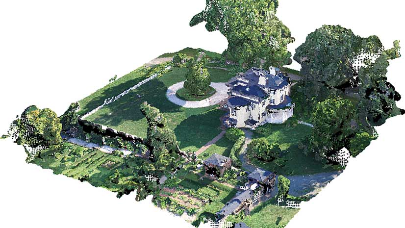
GIS provides critical program support for field data collection, data management, mapping, modeling, and fiscal analysis. To introduce students to GIS in precision agriculture, Fox developed an ArcGIS Desktop training program that includes seven exercises that guide students from introductory GIS concepts through preparation of a multidisciplinary project reference map to mapping, modeling, and analyzing field performance, crop yield, and finances.
These exercises were written and compiled into a textbook, Precision Agriculture GIS Technologies for Mississippi, First Edition. The book contains chapters on file management, soils data mapping, geographic and projected coordinate systems, weather datasets, navigation, and telemetry. Copyrighted in 2019, Fox licensed the book under a Creative Commons Attribution-NonCommercial license to reach a larger audience and support similar programs with materials. It is available as a PDF for free download and unlimited educational use from a PDF for free download. A chapter from this book inspired the tutorial “Making a Precision Reference Map in ArcGIS Pro” that Fox coauthored with Mike Price, which is in this issue of ArcUser.