Sasa Arsic, a graduate student at Claremont Graduate University (CGU) in Claremont, California, used the deep learning capabilities in ArcGIS Pro to map ancient irrigation systems in the Middle East.
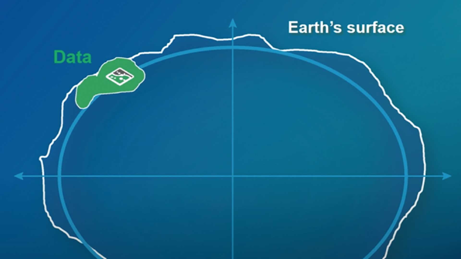
Called qanats, these systems are underground channels that have been used for thousands of years to transport water in arid areas with minimal loss from evaporation and without pumping. These systems not only provide a cultural link but support sustainable development and water management planning.
Arsic is enrolled in the Master of Science in Information Systems & Technology (MSIST) program. Originally from Switzerland, he is an entrepreneur who is interested in applying innovative technologies and has become a GIS enthusiast.
“I was pretty new to GIS when I first entered the program [at CGU], but I liked the work the faculty was doing, and I wanted to learn more,” said Arsic. His interest increased after a stint as an intern at Esri during the summer of 2019. He worked as a UX/UI software engineer on the geoprocessing team, focusing on front-end development and enhancing the user experience and software UI dialogs for spatial analysis tools for the newest version of ArcGIS Pro. Arsic knew he wanted to continue exploring the potential of the software in his own educational projects.
That led him to an independent study course, GeoAI: Data Science with ArcGIS and Drone-Based Imagery Collection, Cloud-Based Processing, and Analysis, with Brian Hilton. A clinical full professor in the university’s Center for Information Systems & Technology (CISAT), Hilton is also the director of CGU’s Advanced GIS Lab. [He has applied GIS to many problems. See “Preserving Voter Rights with the Help of GIS” in the Summer 2019 issue of ArcUser to read about his collaboration with fellow faculty member Jean Schroedel.]
While determining the course design, Arsic stumbled on a Learn ArcGIS lesson available from Esri at no cost called Use Deep Learning to Assess Palm Tree Health. Taking this course set the stage for pursuing a project he had heard about through the faculty grapevine.

Applied Learning
University of Gothenburg, Sweden, geologist Rodney Stevens works with an international group of researchers on a project called Qanat GIS. The project studies qanats in the Middle East, particularly Afghanistan, to assess groundwater resources available to people living in arid and semiarid regions. Accurate maps of active and inactive qanats are essential to supporting sustainable development and managing water sources in desert areas.
Since reliable maps are not available, Stevens asked for GIS help from his long-time friend Lorne Olfman, a professor and director of CISAT. Olfman passed that request on to Hilton and Arsic. Using knowledge he gained from his independent study course with Hilton, Arsic applied several deep learning models to satellite imagery to detect the location of qanats.
“It turns out that detecting palm trees is a lot like detecting qanats,” Arsic said. In discussing the project with Hilton, they decided to use the same workflow Arsic had learned in the Learn ArcGIS lesson.
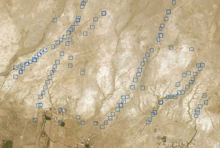
In ArcGIS Pro, satellite imagery of an area west of Kandahar, Afghanistan, showing access shafts was used by Arsic to manually identify their locations and generate samples and an Esri model definition (EMD) file that would be used to train a deep learning model. [An EMD file is a metadata descriptor that contains information about the chip size of the samples and the deep learning framework used (e.g., CNTK or TensorFlow), and—most important—specifies the Python raster function (PRF), which lets the model be integrated with the inferencing workflow in ArcGIS Pro. Several out-of-the-box PRF are supported. but a custom PRF can also be used.]
Training the Model
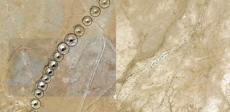
Access shafts are required to create and maintain qanats. These shafts, dug by hand, intersect the underground water table and are visible from the surface, indicating the locations of qanats.
Using ArcGIS Pro, Arsic was able to distinguish two categories of access shafts: active and damaged. Access shafts for active qanats have an easily discerned round shape and a clear, dark hole at the center, unlike the shafts for qanats that are damaged or filled with sediment.
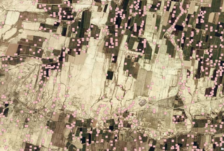
In addition, the environment surrounding the qanats was categorized into two types. In the first category, qanats located in desert areas with little evidence of habitation appeared as simple colors in satellite imagery. In the second category, qanats located in more inhabited areas, surrounded by croplands, appeared more colorful and complex in satellite imagery.
More than 1,000 qanats were labeled using ArcGIS Pro and exported as 512 x 512-pixel image chips. [Image chips are small blocks of imagery cut from the source image.] Chips were processed in batches of six.
The analysis workflow used was the same one taught in the Learn ArcGIS lesson. The batches of processed imagery chips were used for training a deep learning model in Jupyter Notebook using the TensorFlow deep learning framework. Arsic trained his model using the SingleShotDetector (SSD) object detection algorithm available as a Python method in the arcgis.learn module.
The model was trained in 40 epochs. Between iterations, adjustments were made to improve each succeeding result. After each epoch, a graph displaying the current logs on training and validation showed whether the model was continuing to learn.
David Yu, a data scientist at Esri, provided advice on training the model. Yu, whose work on the Esri GeoAI team includes image classification and object detection, helped tweak the model after each iteration and guide it in the right direction. Arsic learned a great deal from Yu, whom he found to be a great coach and mentor. Yu explained complex techniques in simple terms.
“Without him, I would have achieved poorer results. I am very grateful he put some time aside to help with the project,” said Arsic.
After training the model, Yu saved it as an EMD file and then used the Detect Objects Using Deep Learning geoprocessing tool, available with the ArcGIS Image Analyst extension, to identify the qanats.
Arsic said they had expected the training model to produce better results when evaluating qanats located in simple backgrounds. Hilton and Arsic thought that more colorful imagery chips would likely confuse the training model and would take more time to provide good results.
Despite yielding a few false positives, the model produced promising results after running 40 epochs. Given its early stage of development—if the model keeps learning—Arsic expects additional training will produce better results. The resultant maps have the potential to indicate patterns of water transportation along valleys, the extent of qanat interconnectivity, and the height of groundwater elevations.
Arsic theorizes that well identification in areas with more colorful backgrounds can be improved by adding more noise to the training dataset so it can adapt to a different context using image augmentation techniques. In addition, other object detection networks, such as YOLO (You Only Look Once) or Few-Shot, might perform better.
Sharing Project Results
Arsic presented his findings at the CalGIS 2020 conference in Long Beach, California. This annual event, sponsored by the Urban and Regional Information Systems Association (URISA), brings together speakers who present workshops and training on a wide range of information system topics. His entry received first place in the Best Student Poster competition, based on its originality, content clarity, visual presentation, and technical details.
“I took this opportunity to present my work to others, as it may help them with similar projects. I am very thankful to Professor Hilton and David [Yu] for their coaching and support, Esri for providing amazing software to all of us students, and for my school sponsoring me to attend the conference.” Asic was grateful not only for the award but for the opportunity to see other great projects.
Future Work
In theory, qanat-based irrigation systems can be used in other regions affected by limited rainfall and water scarcity issues. For areas of Afghanistan and the Middle East, this project is merely the beginning of efforts to improve crop selection, ameliorate drought, and enhance other aspects of environmental sustainability. For now, Arsic is happy to start scratching the surface… or, perhaps, digging it up.
“These results are just the tip of the iceberg. There is so much more to do here in order to help water management in these arid regions,” he said. “It’s amazing to think that some of the qanats are still in use. I would love to visit these tunnels in person someday.”
For more information about the GIS program at CGU, contact Nick Owchar, executive director of advancement communications.
About the author