According to the Centers for Disease Control and Prevention (CDC), since 2013 more than half a million Americans have died due to opioid overdoses. The illegal distribution of prescription drugs—opioid diversion—is a major contributing factor to this epidemic. To combat this, health-care workers or persons who are exploiting the healthcare system need to be identified.
This starts with looking at data associated with patients, the physicians who prescribe opioids, and pharmacies that distribute opioids. Health-care evaluators and auditors attempt to detect fraud by monitoring opioid distribution networks. They need to visualize the relationships between patients, physicians, and pharmacies to uncover patterns that are not easily discerned.
Combining data regarding patients, physicians, treatment centers, and opioid prescriptions can be overwhelming. It is difficult to track relationships without the right software. With limited resources to tackle this issue, auditors need to know where to best focus their efforts. They need to examine the networks formed by physicians, treatment centers, pharmacies, and patients through a geographic lens.
ArcGIS AllSource is powerful intelligence software that enables auditors to understand the irregularities in the spatial connections between the components of these networks. Auditors can analyze and visualize the data through multiple views, including maps, timelines, and charts—particularly link charts. These tools enable auditors to quickly identify outliers that can indicate possibly fraudulent activities.
ArcGIS AllSource allows auditors to view locations of patient homes in relation to physicians and pharmacies. By interrogating the data, they can answer questions such as, How far are patients traveling to a specific doctor or pharmacy? How many pharmacies were closer to the patient than the one used? Answers to these and other questions can focus investigative efforts into illegal activities by physicians, treatment centers, and pharmacies.
In one interface, ArcGIS AllSource lets auditors connect disparate and large data sources so that potential bad actors can be more efficiently identified. The automation of AllSource workflows enables users to rapidly identify fraudulent behavior. Because workflows are captured, they can be shared with other cities, states, and agencies. Auditors can disseminate their findings to explain the analysis, display results, and support investigations.
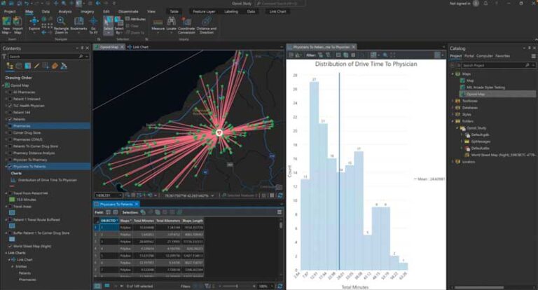
In the following example, an auditor began by mapping a physician’s office in western New York and each patient to whom he had prescribed opioids. By examining the distance between each patient’s home and the physician’s office, outliers were uncovered. These outliers were patients who drove abnormally long distances to see this doctor for a prescription.
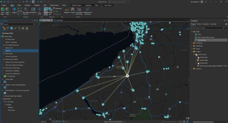
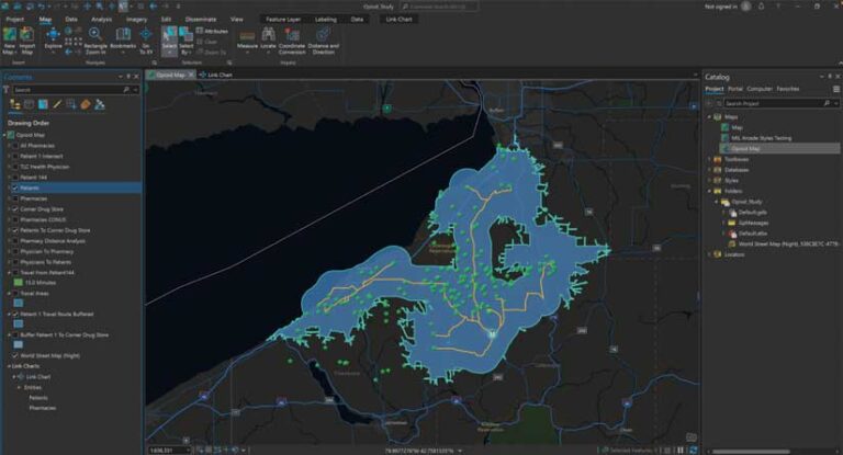
The auditor also looked at the pharmacies that filled these opioid prescriptions. Geographic networks revealed where opioid prescriptions were most often picked up. One pharmacy was being used much more often than other pharmacies. Another distance analysis was performed on pharmacies and prescription holders. Ultimately, this revealed how far patients drove to this specific pharmacy. This analysis identified a pharmacy that had patients who drove remarkably long distances to fill prescriptions. A buffer and drive-time analysis showed an average of eight other, more convenient pharmacies that were bypassed on the way to this pharmacy.
ArcGIS AllSource analysis in this example helped reveal potential bad actors and facilitate investigation in a timely manner. Identifying potentially corrupt physicians and pharmacies gives law enforcement solid leads that can be acted on to make communities safer. ArcGIS AllSource helps investigative professionals make data actionable using seamless, straightforward, and organized searches.
About the authors

Julia Smyth