In today’s ever-changing health-care landscape, data-informed decision-making is vital for organizations to navigate complexities with confidence. Geospatial data, harnessed through GIS technology, provides a powerful foundation for strategic planning, operational efficiency, population health management, equity initiatives, and targeted marketing. This article explores how geospatial data underpins informed health-care planning, empowering organizations to purposefully align decisions with health system needs while also driving positive health outcomes.
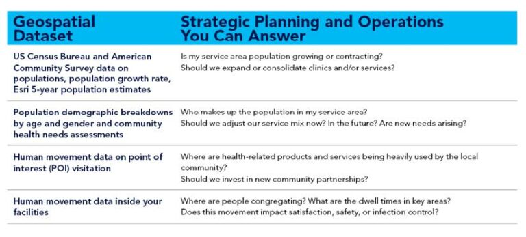
Geospatial Data for Strategic Planning and Operations
Geospatial data serves as the backbone of strategic planning and operational efficiency in health care. By integrating various data streams, such as demographics, health metrics from electronic health records, public health data resources, and health-care facilities information, GIS enables organizations to gain a comprehensive understanding of their current situation and forecast potential changes.
This data-informed decision-making reduces uncertainty and guides critical determinations, such as facility siting, resource allocation, and the deployment or expansion of telehealth services. It can help organizations avoid costly errors by anticipating competition; identifying underperforming sites early; and monitoring unusual or inappropriate utilization patterns, such as overuse of hospital emergency services for preventable conditions like asthma exacerbation or hyperglycemia. Geospatial insights help organizations optimize service mix, align offerings with community needs, and facilitate sustainable growth strategies.
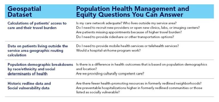
Geospatial Data for Population Health Management and Equity
Population health management is a critical application of geospatial data. GIS aids in stratifying risk across served populations, identifying high-risk communities, and guiding targeted interventions. Geospatial analysis enables health-care organizations to answer vital questions such as, Where are the high incidences of chronic diseases? Are certain populations facing barriers to accessing care? Where are there disparities in health outcomes and what are the root causes?
This insight helps organizations direct resources where they are most needed, improving health outcomes and reducing disparities. By incorporating historic redlining data and vulnerability indexes, geospatial analysis can unveil persistent structural inequities and inform modern multidimensional solutions.
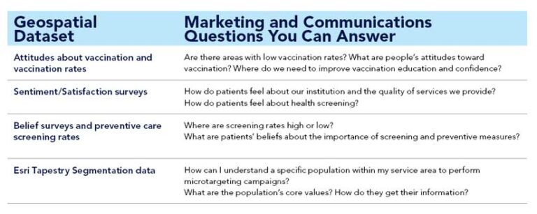
Geospatial Data for Marketing and Communications
Geospatial data plays a crucial role in targeted marketing and effective communication with patients and communities. Demographic data, combined with lifestyle and behavior insights, allows organizations to tailor messaging, services, and care delivery to specific population segments. In addition, geospatial insights derived from attitudes, beliefs, and sentiments help organizations understand community preferences, urgent concerns, and engagement patterns. By leveraging geospatial data, health-care organizations can deliver personalized and impactful marketing campaigns that foster patient engagement and satisfaction.
Geospatial data is a transformative asset in health-care planning. It offers valuable insight for strategic decision-making, population health management, equity initiatives, and targeted marketing. By harnessing the power of GIS, organizations can align resources with health system needs, reduce disparities, and enhance health outcomes. Geospatial data enables health-care organizations to navigate complexities with precision and effectively deliver patient-centered care. Using GIS, organizations can make data-informed decisions that positively impact communities. Embracing geospatial insights as a foundational element of health-care planning empowers organizations to adapt, innovate, and drive meaningful change in the ever-evolving health-care landscape.