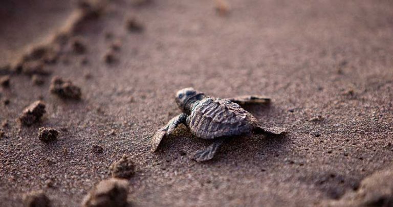
All five species found on Florida beaches—loggerhead, green, leatherback, hawksbill, and Kemp’s ridley—are listed as either threatened or endangered under the Endangered Species Act.

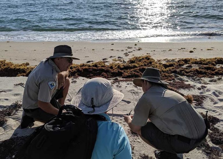
For the past 40 years, between March and October, early risers along Florida’s coastline may see groups of people walking the beach, heads down, and focused on the sand. They occasionally stop, kneel, point, and take notes. These people are data collection teams purposefully searching the beaches to find and identify evidence of sea turtle activity.
Over the past five decades, human activity has caused sea turtles to become endangered. For example, the population of Kemp’s ridley turtles, the smallest and most endangered sea turtle species, has dropped from an estimated 42,000 in 1947 to about 700 in 1985. The numbers began to rebound in the 1980s. In 2003, the population of Kemp’s ridley turtles was estimated at about 8,200 adult females, that foraged predominantly in the northern Gulf of Mexico.
In addition to negative impacts of commercial fishing and plastic waste, climate change has also become a significant threat to sea turtles as extreme weather events increase and the warming sand affects their eggs. To ensure these beautiful creatures don’t become extinct soon, the Florida Fish and Wildlife Conservation Commission (FWC) regularly takes an inventory of species’ numbers and nesting locations.
This important work has been carried out since 1979, when the FWC started the Statewide Nesting Beach Survey (SNBS) program to document the total distribution, seasonality, and abundance of sea turtle nesting in Florida. Another program, the Index Nesting Beach Survey (INBS), was added in 1989 to survey a subset of SNBS beaches. Designed to measure seasonal nesting, the INBS collects additional data such as nest inventories on 27 beaches statewide to help monitor the success of nests (or clutches) at each beach.
As a critical nesting ground for sea turtles. Florida hosts nearly 90 percent of the endangered Loggerhead species. Survey teams focus on five different species—loggerhead, green, leatherback, Kemp’s ridley, and hawksbill—and record their activities. Until now, however, collecting this data has been a manual exercise using pen and paper and manually inputting data into spreadsheets.
“With this time-intensive process, it could take several months to tabulate all the data and produce essential reports that allow managers to identify widespread trends or problems,” said Andrew Williams, a GIS technician in the Florida Department of Environmental Protection (FDEP) Bureau of Natural and Cultural Resources (BNCR) division, which compiles the collected sea turtle information from the Florida State Parks beaches and provides it to the FWC. “We also didn’t consistently receive all the data acquired from the parks, and sometimes certain data was missing to complete a report.”
That all changed in 2020 when the SNBS went digital statewide. Instead of the clipboards, pens, and paper, teams used Trimble handheld GNSS survey devices and ArcGIS Survey123 software to record sea turtle data. The change has not only given managers the opportunity to visualize and analyze activity in near real time, it led to an award made to the FDEP (and BNCR) with a Florida TaxWatch Productivity Award, a distinction that highlights efficiency gains in work.
The Case for Digital
The digital transformation began in 2017 with Williams and his colleague, Leah Gerlock, a natural resource specialist with BNCR and the statewide coordinator of sea turtle nesting data collection for the Florida Park Service (FPS). Having GIS backgrounds, they both knew they could make the data collection and dissemination process more streamlined and efficient with mobile devices and Survey123 field data capture software.
“With a GIS-based data collection app, we could capture data digitally as well as visually and display the information through the ArcGIS Online database, enabling specialists and managers to identify risks or issues in near real time,” said Gerlock. “We couldn’t provide that dynamic and timely data environment with paper and pen.”
Equally important in acquiring GIS-ready field data was enhancing that data with consistent and accurate GNSS positions. Location data wasn’t always captured in the past.
To cover the roughly 825 miles of beaches and 40 different state parks involved in the SNBS, BNCR would need from 50 to 60 mobile devices for data capture. The units would need to be rugged enough to cope with the weather, salt water, and a rocky and sandy environment, and still be powerful enough to run the Esri software efficiently and provide submeter GNSS accuracy. In addition, the devices needed to allow users to capture data offline to cope with mobile connectivity issues.
After testing and narrowing down several handheld devices and tablets, BNCR launched a test in 2018 using a Trimble TDC100 handheld GNSS data collector. Working in conjunction with the FWC, BNCR initially targeted only five parks. However, the parks’ response was so enthusiastic, BNCR expanded the digital trial to 12 parks. Confident that the new digital survey app would provide the efficiency and precision expected, Williams and Gerlock trained a significant roster of individual park coordinators, staff, and volunteers on the Trimble-Esri system for the 2019 sea turtle nesting surveys.
Proving the Concept
FDEP’s goal in 2019 was to survey as many state park beaches as possible using ArcGIS Survey123 and TDC100 devices. This included all 15 FPS index beaches. [Index beaches are a smaller group of beaches within the larger group of beaches and more detailed data is gathered for these beaches.] In total, FWC had about 200 people involved in the new digital surveys.
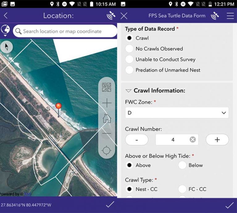
Once field teams determined their areas of interest, they used the built-in GNSS receiver in the TDC100 to establish a highly accurate location to ensure that the data collected met the required precision. Walking or driving all-terrain vehicles (ATVs) along the beach, surveyors searched the sand for signs of turtle activity, such as tracks known as crawl marks, left in the sand or nest predation. When activity was found, the location was recorded with 1 meter accuracy, and the details were documented using drop-down menus using ArcGIS Survey123. If surveyors observed no activity or were unable to conduct the survey due to extreme weather events, they also recorded that in the application.
The ease and intelligence of the customized Survey123 form greatly assisted data capture. Surveyors could confirm their location using an offline basemap included in the survey, and then choose the relevant data—crawl, false crawl, predation—to record. Based on the type of activity captured, Survey123 prompted users to provide additional detail, ensuring comprehensive attribute data. Preprepared customization of forms enabled teams to capture information more quickly ensure data collection was consistent in quality and content.
As data was collected offline, the program’s park coordinator reviewed each day’s data capture for quality control and then submitted the information to the database on ArcGIS Online for instant sharing and spatial viewing.
“We developed a standardized data collection form that met the needs of every state park,” said Williams. “That allowed staff and volunteers to use the same simple, yet comprehensive interface and capture accurate and reliable sea turtle activity in just a few menu clicks. Paired with the Trimble TDCs, we’re saving thousands of hours, and the data is more accurate.”
Based on its success in 2019, BNCR expanded the Trimble-Esri system statewide for the 2020 season, equipping all 40 parks with the means and knowledge to capture data digitally. For the highest-density parks, it acquired nine Trimble TDC600 handheld devices to manage the vast data volumes.
For the 2020 surveys, several hundred people surveyed 219 beaches, covering approximately 839 miles of Florida’s coastline. For the state park beaches, teams digitally collected 6,887 nests for all five species combined.
In the Know
In addition to the efficiency and accuracy gains provided by the mobile survey app, the dynamic accessibility and data analysis provided by ArcGIS Online significantly contributed BNCR’s success. BNCR used ArcGIS Web AppBuilder to develop 40 customized, individual web maps for each of the 40 FPS parks. When park coordinators submit new data, ArcGIS Online is immediately updated as well as the web map for that specific park. This makes any new information available as soon as it’s received or edited.
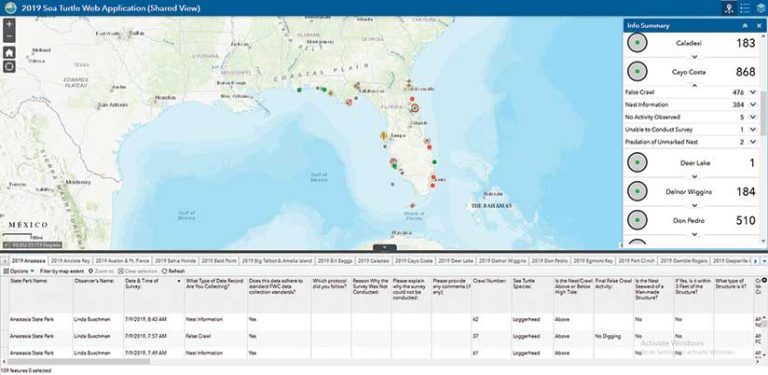
Using other customized web applications and widgets, park coordinators and managers can quickly analyze data and offer specialized information, such as how many loggerhead nests have been reported to date or if a particular rare species has been spotted. Data editing is much quicker and easier, and any data can be exported to create reports. It’s a level of data sharing and visualization FOS has never had before.
The same is true for the BNCR and the FWC. With support from Aaron Koelker, a GIS systems project analyst with FDEP, Williams and his colleagues can use customized Python scripts to quickly compile and convert data into the various formats needed for each park’s monthly report to the FWC. This customization saves substantial time. For the FWC, the responsiveness and completeness of the new data collection system has provided entirely new insight to help protect and support endangered sea turtles.

“With our new survey app, once the records are synchronized with the database, it is possible to see the most recent nests around the state and know when and where nesting is occurring,” said Gerlock. “We can also identify when there has been an event involving a rare species in one of our state parks, or where there may be issues with predation. This has allowed FWC to stay more informed and provide assistance faster than ever before.”
About the author