The Kansas Water Office (KWO) adopted ArcGIS, which enabled the analysis, display, and clear communication of complex information about the state’s water plan to its many stakeholders.
In devising strategic plans that sustainably and equitably manage and develop water resources, state water agencies must deal with the challenges of climate change, the increasing demands of human populations, and the depletion and degradation of ground and surface water stores.
KWO is a state-run agency that communicates, coordinates, and provides marketing resources to support the Kansas Water Plan. The statewide water plan is the primary source document developed by Kansas officials to address the availability of water supplies and plan for a sustainable future.
The plan’s objectives include conserving and extending aquifer water levels, protecting reservoirs, improving overall water quality, reducing vulnerabilities to extreme weather events, and increasing awareness of water resource needs through public education. The plan is also used by residents, advocacy groups, and local governments to enhance awareness of water needs in the state.
Meeting the Needs of Many Stakeholders
KWO has multiple stakeholder groups that need access to information at various levels of detail. The agency needed an efficient solution that would explain and easily display the State Water Plan Fund (SWPF), which is created to implement the state water plan.
Projects are funded by water user fees and general tax contributions to the state. Annually, funds are distributed to multiple state government agencies for projects including watershed dam construction, irrigation technology, basin management practices, water use studies, crop and livestock water research, water education, public water supply support, and flood response.
The distribution of funding is guided by considerations relating to conservation, sustainability, and education. Programs being considered for funding are reviewed by KWO and other state agencies involved in creating the annual budget. Then recommendations are made to the governor and state legislature to ensure that water policies and programs equitably address the unique needs of residents and supports the state’s water resource goals.
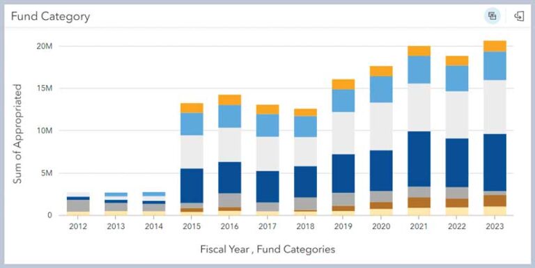
Previously, KWO used spreadsheets and narrative reports to share this data, but this did not share the SWPF information in a meaningful and impactful way. For example, fully appreciating the current year’s appropriations required seeing data for funded categories in the context of funding for those categories over recent fiscal years. That was difficult or impossible using those methods.
With the need for effective communication with stakeholder groups and the requirement to implement the state water plan in conjunction with the SWPF, leaders at KWO saw an opportunity to be innovative and efficient in their data sharing approach.
Interactively Providing Information
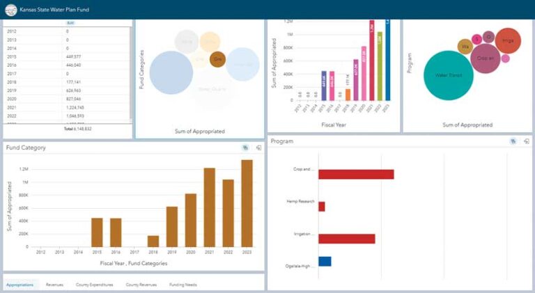
KWO realized a GIS solution could create efficiencies in its data sharing processes. The agency chose ArcGIS Insights, a self-service location analytics application that allows users to explore data and cross-filter results. With ArcGIS Insights, it was also easier for KWO staff members to provide stakeholders with more detailed information to answer specific questions.
KWO also uses GIS to show past areas of focus and identify the need for future funding requests. This leads to faster, better-informed budgetary decisions. Kansas residents can access the interactive charts, graphs, and tables to better understand and advocate for their needs. The data in those charts can be exported in a comma-separated value (CSV) file for further analysis.
Using the data and tools in ArcGIS Knowledge, past public budget data can be analyzed, and project funding reviewed. The detail provided helps residents understand how specific water needs fit into budgetary decisions made by elected officials.
Making Water Data More Accessible
KWO has a lot of information to share, and it now has a simple way to do that using a single access point. A hub site, created using ArcGIS Hub, shares information about appropriations that are based on priorities in the Kansas Water Plan and revenue generated from fees, fines, and fund transfers. This site also lets users interact with data using interactive graphs and charts and contains links to background information and relevant statutes before diving into the information.
“[Using the ArcGIS Insights and the hub site] regional planners have been conducting informational sessions to ask questions of stakeholders, and this information loop helps us to understand what is important to regional users through facilitated discussions. We are also more efficient by not replicating multiple regional static maps. With an easy upload of data, next year’s fiscal data can be easily viewed,” said Katie Goff, GIS coordinator at KWO.
Building in time-saving measures for KWO staff has also streamlined communications with stakeholders. “Internal staff [have] found the solution incredibly helpful. When they are asked questions by residents or regional members, they now have a better understanding of the data. This helps facilitate better conversations and decision-making processes,” Goff said.