Before embarking on a digital transformation using ArcGIS, Gachina Landscape Management staff members used different colored pencils to draw the irrigation zones for a client’s property on 8.5- by 11-inch college ruled paper. They tacked up sticky notes that described plant materials and hardware such as controllers and valves.
Gachina Landscape Management, headquartered in Menlo Park, California, provides a full range of landscape services to about 1,000 clients in the San Francisco Bay Area and Monterey Bay—large corporate campuses; homeowner associations; country clubs (excluding golf courses); school districts; and several federal, state, and local government organizations including cities and towns. The company, which employs 400 people, ranked number 55 on Landscape Management magazine’s top 150 revenue-generating companies in 2020, with close to $40 million in revenue.
The average size of a client’s landscape is about 2.5 acres, so Gachina landscapers care for approximately 2,500 acres. They install and operate irrigation systems, create drought-resistant landscapes, and provide landscape maintenance services.

Finding a Better Way
While many other landscape companies were using hand-drawn irrigation maps—and continue to do so—Chad Sutton, water resource manager for Gachina, decided change was in order. “I said, ‘We are going to find a better way.’ So that is exactly when the digital transformation started,” said Sutton.
The year was 2014, and Sutton, an irrigation expert and lifelong landscaper who had just been hired by Gachina, happened to see maps created by the City of Fremont that used Esri software. The maps defined the areas where Gachina was contracted to spray herbicides and pesticides and delineated where spraying had already been performed. Sutton saw immediately that the same technique could be used for irrigation mapping. He thought that if the City of Fremont could do it, Gachina could probably do it too.
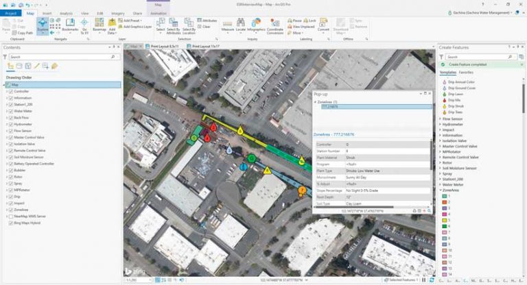
Today most of Gachina’s irrigation maps are maintained in a GIS and can be accessed by irrigation technicians on their phones. Using Esri products such as ArcGIS Pro on the desktop, ArcGIS Online in the cloud, and the mobile app ArcGIS Collector (iOS), Gachina collects and edits irrigation-related data for each client’s property, creating and managing a geodatabase that contains the information. It shares pertinent irrigation information through custom PDF maps or web maps for clients.
Irrigation technicians in the field use the ArcGIS Explorer mobile app on Apple iPhones to view the maps hosted in ArcGIS Online. If edits to data are needed, they can be made in the field by Sutton and other staff members using ArcGIS Collector on their iPhones, and the geodatabase will be updated in real time.
With irrigation data digitally mapped with GIS, Gachina can make well-informed irrigation system-related decisions and accomplish the following:
- Irrigate clients’ properties more efficiently, saving water and money.
- Create optimal water budgets that establish the expected amount of water that a site will need in any given time period by taking into account historical weather data, the size of the property, and other factors.
- Respond in a faster, more informed manner when issues arise.
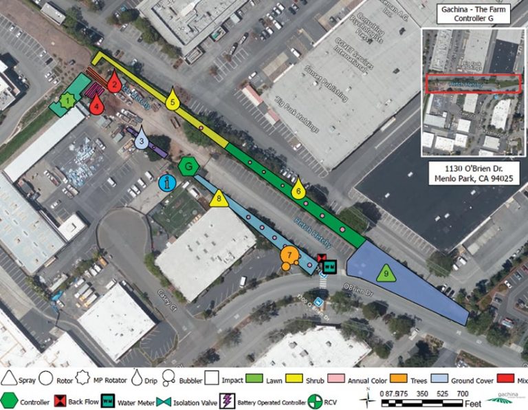
- Provide clients with irrigation maps of their properties in PDF format. Clients with Gachina’s premium GIS irrigation mapping service receive access to a much more detailed web map.
- Share information with property owners, managers, and outside contractors who need to know exactly where the irrigation system equipment is located.
Managing Almost a Billion Gallons of Landscape Water per Year
Sutton, who leads GIS projects at Gachina; Salvador Gutiérrez, GIS developer in the IT Department at Gachina; and their teams manage close to one billion gallons of landscape water annually.
With the San Francisco Bay Area in extreme drought, according to the U.S. Drought Monitor map, water conservation is a high priority for the company. “We are really trying to [encourage] our clients to put in low water use, attractive, drought-resistant, and resilient landscaping,” Sutton said.
To help manage irrigation water usage and get the details needed to program each irrigation controller to be water wise, in late 2014 and early 2015, Sutton and Gutiérrez began to use ArcGIS Pro 1.0 beta to start the process of creating a geodatabase schema for the data that the company collects for each zone of its clients’ sites.
They customized that schema with features, layers, symbology, and attribute values. Some attributes in the geodatabase included plant types, root depth, and water use requirements based on those plant types; site characteristics such as microclimate; slope percentage; soil type; sun and shade exposure; and information on the irrigation system such as types of sprinklers or drip irrigation systems, the irrigation pipe manufacturer, and valves. More detailed information can be added in the notes field, such as the names of the plants or flowers in each zone. Gachina does not map the location of individual sprinklers unless a premium service client requests it.
The information in the geodatabase, created in ArcGIS Pro, is published as layers that are hosted in ArcGIS Online, where Gachina staff can call up a client’s irrigation map, click on a zone, and view a pop-up containing pertinent information associated with each zone. That information helps staff determine the amount of water each zone in the site receives.
Landscaping today is a science. Overwatering is a big issue in the world of landscaping, according to Sutton, which is why adding information, such as root depth, in the geodatabase is critical.
“We were not getting anywhere near the level of detail and specificity that we needed in a consistent manner with those hand-drawn maps,” Sutton said. “This GIS geodatabase is where we defined all the questions that needed to be answered to program a controller properly.”
“We don’t want to water deeper than the roots grow. We don’t want to force water 24 inches down if there are no roots down there to suck up the water,” Sutton said. “Overwatering is a silent killer of plant material and also budgets. We show our clients that not only are we going to save them water and save them money, but their plant material is going to look better and live longer.”
If new drought-tolerant plants are added to a landscape, for example, that information will be collected in the field using ArcGIS Collector and automatically updated in ArcGIS Online. That new information will be factored into adjusting the irrigation scheduling.

“We need to build on that GIS database to help us understand how to program the irrigation controller properly for that zone,” Sutton said. “We can edit that in the future quickly and easily as things change. That efficiency gain is what’s going to make us better water managers and help us conserve more water and help our clients save more money and make the [property] look better.” He estimates that using GIS for irrigation mapping and providing those maps to clients leads to significant savings in both water and money.
Sutton also utilizes the information in the geodatabase—along with maps created in ArcGIS Pro that bring in US Geological Survey (USGS) soil maps and the satellite imagery in Microsoft’s Bing Maps—to help create water budgets for each client’s site. Gutiérrez also uses high-resolution aerial imagery from Nearmap, an Esri partner.
“We need to have super high-quality, very detailed basemap satellite images to work off of—that’s been really important to us,” said Sutton. “We [don’t need the] big 50,000-foot view. We’re down in the dirt, you know?”
Sutton takes topography, plant material, soil type, and other factors into account when devising a water budget formula. “I am kind of using the database as a way to help me quickly get to a water budget for the site,” Sutton said.
The Value of Communication
The maps also are a great resource for knowing what types of hardware are installed in each zone on a client’s site, which is critical when repairs need to be made by field crews. Having irrigation assets digitally mapped lets Gachina staff and clients share information more easily via Gachina’s GIS mapping service.
With Gachina’s premium mapping service, assets such as spray and rotor sprinklers, drip systems, controllers, isolation valves, and water meters are mapped. This is valuable information when construction work needs to be done, or a water leak occurs, or when landscaping isn’t receiving adequate water.
The ArcGIS Explorer app also helps crew members locate assets. It gives them a standard knowledge base when they are out in the field, which can save valuable time. Turnover can be high in the landscaping business: people transfer within Gachina, find new jobs and leave, or retire. Now crew members can call irrigation maps up on their iPhones so that even employees new to the job instantly get a good picture of where everything is located.
“They need to be able to hit the ground running as fast as possible,” Sutton said. “They need to learn that site as quickly as possible and not take the three to five years it took for that last person without a map to figure it all out themselves.”
“Giving our whole team the ability to carry more than 1,000 irrigation maps on a mobile app on a phone that’s in their pocket is incredible,” said Gutiérrez.
Providing GIS Maps to Clients
The maps that Gachina provides to clients are created using ArcGIS Pro. The PDF fulfills most clients’ needs, according to Sutton. “They just think it’s beautiful and amazing and light-years beyond what they used to get,” he said.
Other customers—including some school districts and some high-tech corporate campuses—want a more detailed map, which Gachina provides through its premium mapping services. Those web maps, which are made using ArcGIS Pro and hosted in ArcGIS Online, can be highly detailed so these clients can use them when doing financial budgeting and construction planning, according to Sutton. These clients realize the tremendous value in having that level of documentation on the map.
Gachina has also used AEC Project Delivery, a subscription service from Esri that gives the landscaping firm the ability to share its internal GIS content and other information with clients and other stakeholders outside its organization.
Sutton said that using AEC Project Delivery has been important for sharing GIS maps and other information with clients and their contractors who are having excavation work done such as the installation of fiber-optic cable. Seeing where the irrigation assets are located on a digital map helps prevent costly damage.
A Vision Fulfilled
Gutiérrez is proud to be part of such a groundbreaking green project at Gachina and is amazed at what has been accomplished in a relatively short amount of time. He said he came on board at Gachina in late 2014 as a gardener but had an information technology degree and was quickly recruited by Sutton for an IT position.
“A couple of weeks later, Chad [Sutton] and I were walking together at a property while he was explaining to me his vision and how cool it would be to carry irrigation maps on phones and give the irrigation technicians the ability to create and edit those maps through their phones,” Gutiérrez said. “He also talked about how cool it would be to help our team and also make some profit by eventually selling that project as a service. I thought, ‘How in the world are we going to do such a thing?’ But I guess the rest is history—because we did it!”
ArcGIS played a major role in the project’s success, according to Gutiérrez. “We were able to plant the seed and then let this project grow organically within Gachina Landscape Management,” he said. “Small steps led us to big accomplishments, and with feedback from our irrigation technicians, we were able to advance the process. What had been carried out manually could now move into the digital world, which is saving paper; money; and, most importantly, time.”