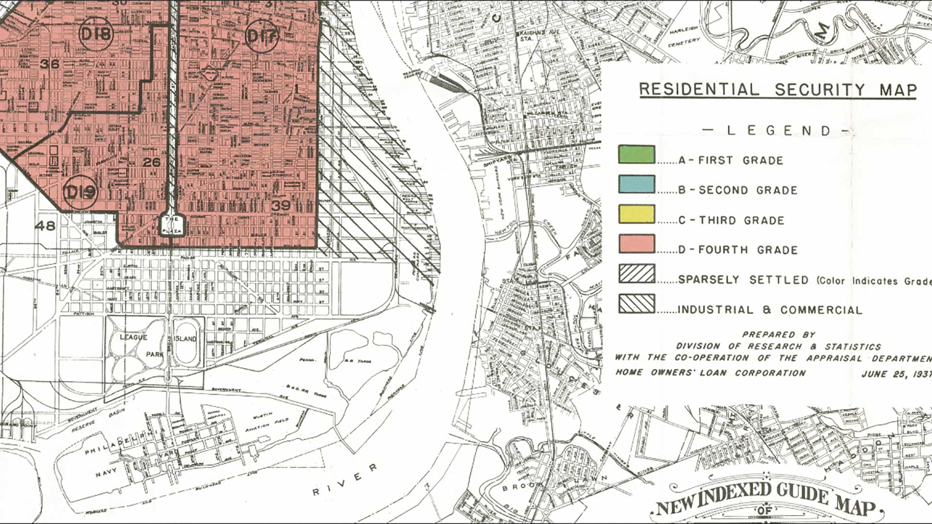
Any conversation that planners and administrators have today about community resilience has to include a sustainable housing policy. A key component of that policy must be access to affordable housing.
According to The 2019 State of the Nation’s Housing, a report released by Harvard University’s Joint Center for Housing Studies, 15.2 percent of households were spending more than 50 percent of their incomes for housing in 2017. The study was sponsored by Habitat for Humanity.
According to Robert Hickey, Habitat’s director of housing policy, the core of the housing affordability crisis is that fewer new homes are being built, particularly starter homes. This circumstance increases rents and home prices at a rate faster than incomes grow.
The role of the planning professional in developing a housing policy that is sustainable, affordable, and equitable is more critical than ever. When people can’t afford to live in the community in which they work, the result can be undesirable sprawl in surrounding communities. Even with an excellent transit system, this will increase traffic on roadways.
Implementing policies that support a sufficient inventory of affordable housing can provide many benefits to communities. These benefits include increased spending power, more educational opportunities, job creation and economic mobility, growing municipal revenue, lower stress on transportation networks, and reduction of poverty by ending the cycle of homelessness.
GIS plays a crucial role in implementing these policies by empowering planners in three main areas: taking a location- and data-driven approach to developing a sustainable policy for housing; creating equitable and attainable affordable housing; and designing a path for economic mobility for economically disadvantaged residents.
Housing Policy Development
In assigning areas for affordable housing, planners and policy makers must be able to define the need, benefits, and challenges. Locating affordable housing directly impacts other policies for mitigating homelessness and improving overall quality of life.
By taking a data-driven approach, planners can develop multiple housing scenarios in neighborhoods and measure their potential effectiveness using apps such as ArcGIS Urban and the Policy Validation App. Policy makers can then evaluate and visualize these scenarios, collaborate with community leaders, and engage the public to meet expectations of transparency and accountability. Specifically, GIS empowers planners to:
- Identify and analyze demographic and socio-economic variables for neighborhoods to assess needs.
- Allocate percentages of development to affordable housing as part of a comprehensive plan
- Evaluate accessibility to essential services, such as transit, education, health care.
- Understand the impact of homelessness in the area.
- Communicate policy to stakeholders and monitor feedback.
Designing Affordable Housing
Effective affordable housing relies on sustainable design that is centered around location. The design needs to incorporate transit-oriented design (TOD) in more dense urban neighborhoods toincrease accessibility to services, education, training, and jobs and create a more walkable and desirable neighborhood.
In addition, affordable housing developments need to blend seamlessly with existing developments. This will generate a more cohesive and inclusive neighborhood that meets the needs of all its residents. Creating even one successful affordable housing development helps justify policies to create additional affordable housing developments in other neighborhoods, expanding these benefits throughout the city.
Many municipalities developed zoning ordinances years—if not decades—earlier and didn’t anticipate the demand for specific types of growth, such as mixed use, that have become widely accepted in the planning community. Previously, many municipalities had to outsource proposed changes to a consulting firm.
GIS benefits the development of affordable housing by empowering planning professionals to design sustainable and affordable housing developments. It aids the modernization of zoning ordinances. ArcGIS Urban allows planners to test different growth capacity and build-out scenarios with modified existing zoning parameters, such as maximum building heights, changes in permitted uses or the creation of new zoning. ArcGIS Hub provides a platform for citizens and stakeholders to learn about development scenarios and provide feedback.
Economic Mobility
Affordable housing and economic mobility are inherently linked. Economic mobility provides a path for residents—particularly low-income residents—to elevate themselves from stagnant economic conditions. Planners, economic developers, and community leaders have the obligation and the ability to design neighborhoods that provide economic opportunities for residents.
These opportunities can be enhanced if employers are incentivized to make long-term investments in personnel. This can create jobs and break cycles of poverty and homelessness.
This also grows municipal revenue, which provides more resources for services. When combined with affordable housing, an economic mobility strategy provides pathways for residents who are disadvantaged and disenfranchised to capitalize on opportunities and make a tighter connection with their neighborhood.
Planners need GIS to develop an economic mobility strategy to analyze and understand community demographics and socioeconomic characteristics and assess community needs for employment, training, education, and services. monitor and quantify status of economic mobility in neighborhoods.
GIS can also be used to coordinate with economic development office (EDO) officials to recruit sustainable new investments and expand existing ones and report to policy makers and the public the impact of mobility in neighborhoods.
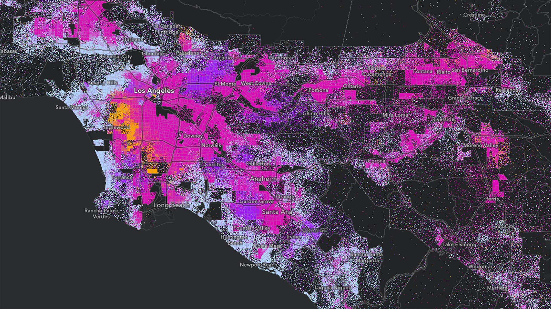
The City of Seattle, Washington, has been using GIS for years and recently used some advanced web-based tools to manage its dramatic growth. Seattle has had the fastest growth rate among the 50 largest US cities since 2010. By using GIS to inventory housing and employment capacity, city policy makers gain a growing understanding of its changing demographics so they could design affordable housing that would be evenly distributed among its many neighborhoods.
The city used the site suitability tools now found in the Policy Validation app and then the design tools in ArcGIS Urban to plan for new and affordable housing in the Eastlake neighborhood.
The City of Charlotte, North Carolina, has taken a repeatable approach to affordable housing. The city used GIS to create site scoring for proposed locations based on proximity to transit assets and amenities, income diversity, reasonable access to jobs, and level of neighborhood change. The city’s housing operations manager and data analytics team did all analysis using web-based tools in ArcGIS.
From increased municipal revenue to decreased auto traffic and poverty to more diverse and cohesive neighborhoods, an effective strategy for encouraging affordable housing and economic mobility benefits all residents.