Just after 7:00 a.m. on March 18, 2020, residents of Salt Lake Valley in Utah were shaken awake by a 5.7 magnitude earthquake. Magna, a community a few miles west of Salt Lake City, was at the epicenter of the quake. Although no one was fatally injured, significant property damage was reported across the valley, primarily impacting unreinforced masonry structures.
The Greater Salt Lake Municipal Services District (MSD) oversees planning and development services in Magna, including building inspections. The MSD Operations team quickly created data collection forms in ArcGIS Survey123. The forms helped the public report damage and field inspectors assess structural integrity. MSD building inspectors partnered with Salt Lake County Public Works structural engineers to triage the damage and more effectively direct response efforts throughout the jurisdiction.
“The day of the earthquake, providing timely, relevant, and reliable data quickly became our most important priority,” said Lupita McClenning, director of planning and development for MSD.
She noted that the MSD Operations team provided data and analytics to support response initiatives. This data was critical in strengthening efforts by other agencies. The MSD team knew leaders needed to have real-time data and analytics to quickly visualize that data so they could effectively make decisions.
“The end goal of using analytics and GIS technology is to inform decision-making for responders, community leaders, and citizens. Incorporating GIS improved planning, analysis, situational awareness, response times, collaboration, and communication during a challenging time,” said McClenning.
Earthquake risk is nothing new to those living along Utah’s Wasatch Front, a metropolitan region in the north-central portion of the state that stretches from Nephi to Brigham City. Within the region, the Wasatch Fault runs north from the near geographic center of Utah through southern Idaho. This region contains approximately 75 percent of Utah’s population, according to estimates by the Kem C. Gardner Policy Institute.
Forecasters at the Working Group on Utah Earthquake Probabilities predict that there is a 43 percent chance that a magnitude 6.75 or greater earthquake will occur along the Wasatch Front within 50 years. The Magna quake was not the “big one,” but it did serve as a potent reminder for what lies ahead.
As the municipal service provider for Magna and the other metro townships, the MSD has applied data-driven approaches to serving the population in the past, and the agency’s response to the earthquake was no different.
Esri tools, such as classic Esri Story Maps templates, ArcGIS StoryMaps, hub sites, custom applications built with ArcGIS Web AppBuilder, and data collection solutions including ArcGIS Survey123 have long been an integral part of regional planning initiatives. They are workhorses for local government.
Forms configured in ArcGIS Survey123 Connect that can be opened in either a web browser or on a mobile device allowed the district to collect residents’ input during the emergency response quickly and accurately. These forms also improved field staff productivity by eliminating paper forms and the need to reenter data. Residents and MSD field inspectors could submit surveys while following the safety practices required during the COVID-19 pandemic.
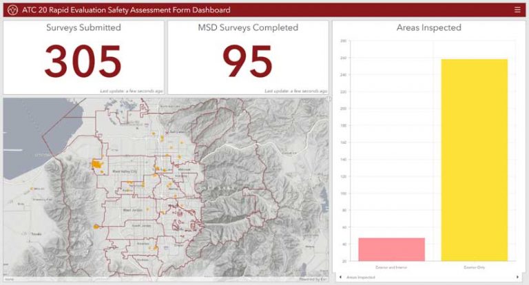
MSD disseminated forms to the public within a few hours via MSD hub sites, social media platforms, news outlets, and municipal websites. These forms helped the MSD gather information quickly and provided better overall service. The Federal Emergency Management Agency (FEMA) requires inspectors to fill out an ACT-20 Rapid Evaluation Safety Assessment for each damaged structure to determine if the public can safely return to homes and businesses. [ATC-20, developed by the nonprofit hazard mitigation corporation Applied Technology Council, is the standard form for evaluating the safety of buildings after an earthquake.]
Within an hour, the ATC-20 paper form, available from the FEMA website, was converted to a live survey. Using mobile devices, each field officer could assess structures. Local authorities, who viewed real-time monitoring of the damage to buildings in the valley using dashboards, could make data-driven decisions about emergency response.
Izabela Miller, operations manager with MSD, said her team worked with emergency management staff to ensure the information collected was sufficient for determining whether in-person inspections of structures were necessary. Salt Lake Valley residents could submit requests for inspections, no matter where they lived.
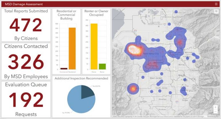
“Nature doesn’t respect boundaries, and during an emergency, cross-jurisdictional local government cooperation should reflect that in the response,” she said. “Using Survey123 and our Damage Assessment Operations Dashboard, we were able not only to reach out to citizens but also to visualize where the damage hot spots were by using the heat map capabilities of ArcGIS Online applications.”
On July 9, 2020, FEMA officially declared the Magna quake an active disaster, making individual assistance available for residents in Salt Lake and Davis counties. As of August 2020, the agency had approved 47 applications from individuals that would provide $154,407 in housing assistance. The nationwide COVID-19 emergency has caused FEMA to use remote inspections to assess damage to homes in Salt Lake County.
The unpredictability of earthquakes is part of what makes them so dangerous. The best thing communities can do is to be prepared and have a response plan. MSD prides itself on the level of service it provides to its residents and is confident in its ability to respond to future emergencies in the communities it serves. Effective local government starts and ends with community engagement, and Esri tools like ArcGIS Survey123 and ArcGIS Dashboards grease the gears of this engagement.
For more information, contact Alex Rudowski at arudowski@msd.utah.gov or Rachel Manko at rmanko@msd.utah.gov.
About the authors

Alex Rudowski