The National Emergency Number Association (NENA) estimates that 240 million 9-1-1 calls are made in the United States each year, and in many areas, 80 percent or more of those calls come from wireless devices. The need to update the 9-1-1 service infrastructure to locate requests for service originating from wireless mobile phones was recognized in 2000 and has led to the development of Next Generation 9-1-1 (NG9-1-1).
The goal of NG9-1-1 is to allow voice, text, or video calls by the public to emergency services via internet protocol-based networks and transfer those calls to Public Safety Answering Points (PSAP). The transition to NG9-1-1 is ongoing and has been implemented (as of this writing) at the state level in California, Arizona, Texas, Montana, Illinois, Missouri, Virginia, and Florida.
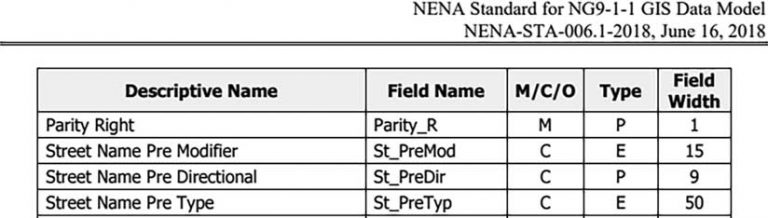
GIS data will be critical when switching to NG9-1-1, because it will be used in two core services of NG9-1-1. GIS will be used in the emergency call routing function, which will dictate which PSAP will receive a 9-1-1 call, and it will be used in the location validation function, which dictates if an address can be routed to a location. To support this, the NENA Standard for NG9-1-1 GIS Data Model (NENA-STA-006.1-2018) was developed. It was approved in 2018.
The author is a GIS analyst for the Brevard County Board of County Commissioners, Florida, Emergency Management. In this article, he shares best practices for making the transition to NG9-1-1.
The Brevard County 911 Administration recently used the NENA Standard for NG9-1-1 GIS Data Model to prepare its address and road layers for transitioning to NG9-1-1. This model should be used when preparing GIS data for migrations to NG9-1-1.
The model specifies how fields should be named, what data needs to be in each field, the field type, and the field width.
To prepare your organization’s GIS data for use by NG9-1-1, you will need to answer the following questions:
What should your attribute table contain?
- Who uses your GIS data?
- How will you get your data NG9-1-1 ready?
- Where do you maintain your GIS data?
- What does each field mean?
- What Should Your Attribute Table Contain?
The NG9-1-1 GIS Data Model calls for the street layer to have 52 fields and the address point layer to have 46 fields. Each of these fields will have to have a specific width, field name, and field type. Fields fall into three different categories: mandatory, conditional, and optional. Mandatory (M) fields must hold an attribute and cannot be left blank. Conditional (C) fields hold an attribute if that attribute exists. Optional (O) fields may or may not be provided.
Who Uses Your GIS Data?
NENA requires that the road centerline and site/structure address point layer be ready for NG9-1-1 implementation. More than likely, these two layers are not only used in your 9-1-1 system but also by other agencies in your organization. Replacing the current fields with the required NENA fields would cause issues for those agencies, especially when this data is used with third-party vendors that need certain fields in specific formats.
To avoid disrupting the workflow of other agencies, initially you might want to add NENA-required fields to your data without deleting existing fields. This gives other agencies time to work with their third-party vendors to switch to those new fields. Eventually you will be able to delete the old fields. Maintaining two sets of fields might sound like a lot more work, but by using Esri’s Attribute Assistant in ArcGIS Desktop or attribute rules in ArcGIS Pro, you will only have to manually fill out one set of fields and the rest will be automatically populated.
How Will You Get Your Data NG9-1-1 Ready?
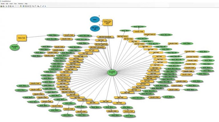
To add the new fields and populate them with data, you want to consider using a model. Since your model will be rather big and time-consuming to create, using ModelBuilder lets you slowly finish it. Your model will incorporate many Add Field and Calculate Field geoprocessing tools. Use he Calculate Field geoprocessing tool to calculate data for a newly added NG9-1-1 field using an existing field and modifying its format as required.
Where Do You Maintain Your GIS Data?
Once you are done building your model, you can run it on live data. If your data resides in an ArcGIS Enterprise environment, make sure to analyze and compress your data once the model finishes running. Making this many changes to your dataset will slow down your features when editing them in ArcMap or ArcGIS Pro. You may not be able to populate some fields using your model, so you will need to finish them manually. To maintain the best performance, make sure to run analyze and compress once you finish each field.
What Does Each Field Mean?
When you are ready to share your data with other agencies that use it daily, make sure you let them know about the data in each new field. Since you will replace current fields with required NENA fields, they will need to know which field will contain the data they currently rely on. The NENA Standard for NG9-1-1 GIS Data Model document has a description for each field that you can use to populate the metadata for your features. This should help them find the data they need.
Conclusion
It is an exciting time to be working as a GIS professional in the 9-1-1 world. The shift from Enhanced 9-1-1 to NG9-1-1 places a lot more importance on your GIS data. While the transition needs to be made as quickly as possible, make sure that you don’t leave anyone who uses your data behind. Because street and address layers are crucial in any location-based application, a lot of outside agencies will be using them. It’s important to let them know about drastic changes to the attribute table well in advance.
About the author