One of the fastest-emerging trends among community planners is zoning reform. This has been gathering momentum for the last three to five years. Three federal funding vehicles have been proposed to primarily fund this initiative. There are several reasons why zoning reform has quickly moved to the forefront of priorities for hundreds of counties.
The Need for Zoning Reform
It all starts with the fact that many zoning codes are antiquated. They were initially developed several decades ago to meet the needs of residents. At that time, many counties may have made patchwork changes, such as adjustments to floor area ratio; increases in setbacks and the proximity of development to wetlands; and changes made to fit demands from residents, administrators, and developers. But these were only temporary fixes and didn’t address the need for reforming codes to meet modern expectations of residents.
Consequently, this makes it difficult (at best) for counties to provide the kinds of housing options that existing and prospective residents need. Single-family housing was in greater demand in the 1970s and ’80s than it is today because the size of the average household has been decreasing. Many residents, particularly those who are young and single, either aren’t looking for or cannot afford these types of homes and would prefer more walkable communities with denser concentrations of housing and better access to stores, restaurants, and transit.
Finally, dated ordinances with restrictions on newer types of housing directly impact housing affordability, as has already been seen in communities of all sizes across the United States. These ordinances severely limit housing options for low- and middle-income households and, by extension, adversely affect economic mobility. People who cannot live close to their work or the services they need may be forced to move farther away to afford housing. This, in turn, increases commuter traffic and limits opportunities for economic growth.
Geographic Approach to Zoning Reform
There is little doubt that changing development parameters is going to be a sensitive topic for residents, developers, and county leaders, so zoning reform requires a data-driven approach. It will be essential for planning professionals and county leaders to embrace a geographic approach to zoning, which includes understanding neighborhood characteristics.
The main drivers for neighborhood zoning reform have changed over the last several decades. Consequently, having a detailed understanding of the current characteristics of these neighborhoods is essential.
ArcGIS Business Analyst Web App provides access to about 2,000 demographic, socioeconomic, workforce, and business variables that deliver detailed insight into the characteristics, market trends, and needs of neighborhoods down to the block group level.
Deriving intelligence from business systems can benefit zoning reform. Nearly every county leverages one or more business systems to record and monitor developments, most often a permitting system. While not everyone in a county directly uses this system, planners and county administrators need at least an overview of the data that it holds.
ArcGIS Insights generates business intelligence from existing community development systems, such as permitting systems, to identify trends and patterns in development over time to show where the greatest need for reform exists. ArcGIS Insights acts as a complement to—not a replacement for— these systems.
Leaders in county government are expected to create, promote, and drive sustainable zoning and development policies that benefit their residents by meeting their needs. More than ever, this requires a data-driven approach. Sometimes knowing where to start for this process can be challenging in and of itself.
A free resource in ArcGIS Living Atlas of the World, Esri Maps for Public Policy, includes curated content focused on policy initiatives, such as housing, economic mobility, and disadvantaged neighborhoods.
Zoning reform is likely to spawn some heated debate. You need to be sure that all your residents have a way to learn and provide feedback about proposed zoning changes is more essential than ever. Simply relying on public hearings and town hall meetings to provide civic inclusion won’t create the inclusivity and feedback that leaders need.
ArcGIS Hub opens the door to all residents and stakeholders so that they will be better informed about specific initiatives. It can also provide direct feedback about plans, using maps, surveys, and videos.
Empowering Scenario Planning and Design
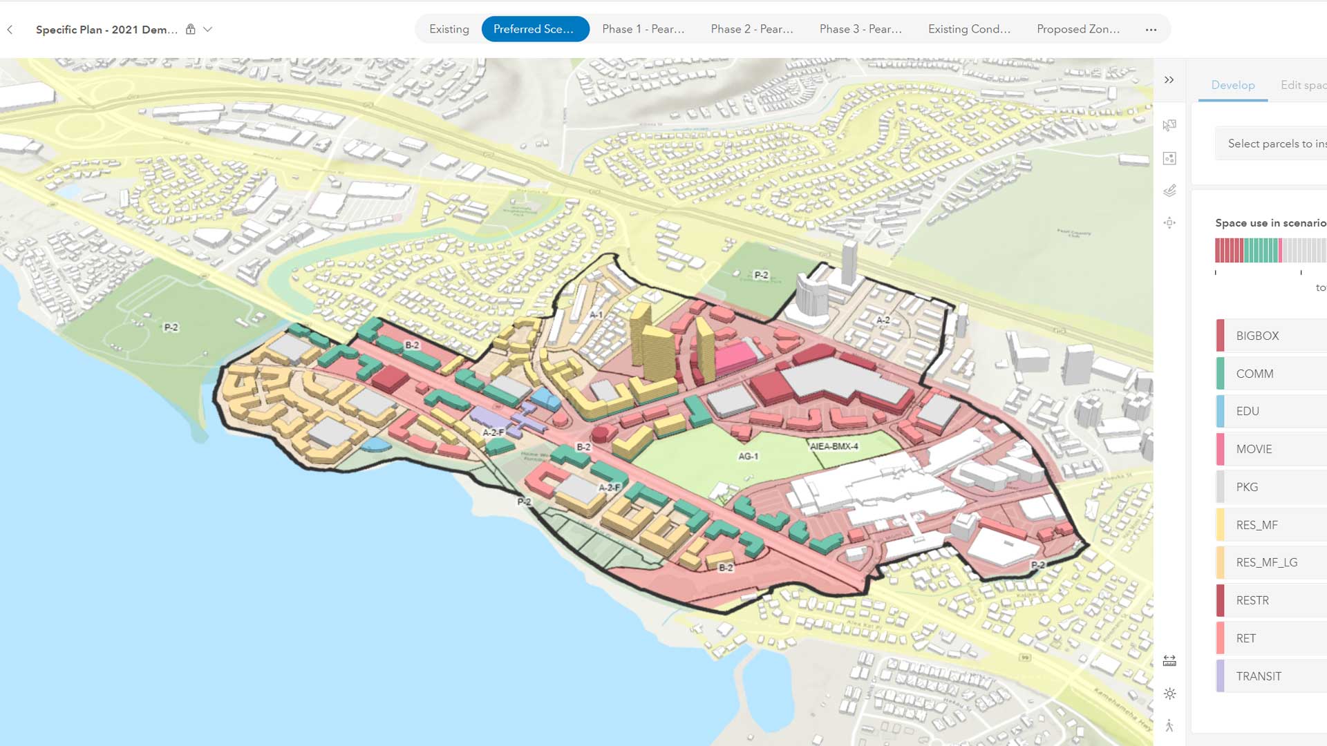
The geographic approach to zoning reform will require creating, analyzing, and comparing multiple scenarios. In the past, this would have required costly outsourcing to a consulting firm. Today, planners can use GIS to create and measure these scenarios to find the optimal zoning changes down to a fine level of detail, including setbacks, building height, dwelling unit density, and housing affordability.
ArcGIS Urban is a web-based tool that enables planners to play out different scenarios for proposed zoning changes. Planners can instantly see the potential impact of a zoning change, including changes in population, increases in jobs, effects on traffic and utilities, and financial impacts. These plans can be compared with others to identify the path forward that best meets the needs of the community.
Reforming a zoning ordinance can be a daunting, time-consuming task. GIS provides the essential tools that planners, residents, and county leaders need to take a data-driven approach to zoning and create a more sustainable, equitable, and thriving county.