Hikers Find and Navigate Trails with a Park Trails App from Allegheny County, Pennsylvania
Tap the app’s yellow icon, decorated with the silhouette of a hiker, and up pops a network of park trails in Allegheny County, Pennsylvania, on your mobile device.
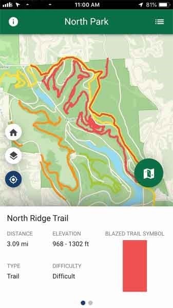
For hikers, bikers, runners, skiers, or horseback riders, the Park Trails app from Allegheny County gives them the information they need to know before they venture out into the county’s nine parks: the names and length of the trails, the blaze colors (used for wayfinding and to differentiate trails), the minimum and maximum elevations on each trail, and the trail difficulty.
The Allegheny County Department of Computer Services-GIS Team and Esri collaborated to create the app, which can be downloaded from the Apple App Store or Google Play. Cool extras include weather information, such as wind chill and humidity, that comes from the National Weather Service (NWS) and the elevation of the user’s location on a trail if the GPS has been enabled.
“The goal of the app was to create something to improve trail access and ultimately promote our parks,” said Eli Thomas, GIS manager for Allegheny County. “We really want to urge citizens to get out there and use them. It’s great to have people enjoy the app and our incredible natural resources.”

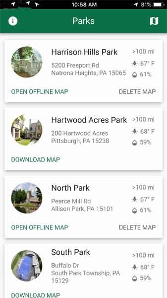
The Allegheny County Parks Department oversees nine parks that span more than 12,000 square acres in Allegheny County, an area that includes the City of Pittsburgh. The parks offer an array of seasonal and year-round activities, including hiking, skiing, bicycling, and horseback riding on more than 200 miles of trails.
Without readily accessible maps, however, navigating all these trails can be difficult. Fieldworkers also needed accurate and easy-to-decipher maps to maintain the trail assets. Thomas and the GIS team wanted to give the public an easy way to access park trails and organize available trail assets more efficiently.
To accomplish this, Brian McBane, GIS field collection specialist, created an inventory of all 200 miles of trails using high-accuracy Trimble GPS devices and Esri field data collection software. He collected most of the point data himself over the last 15 years by walking the trails with some help from Thomas and Dave Wright, a road engineer from the county’s Department of Public Works.
“At [each] park, I walked the trail to be mapped and stopped every 20 or 30 feet to create a point,” McBane said. “When I was finished for the day, I had many points to document the trails. Back in the office, I uploaded the point data to an ArcMap project. I started an edit session on a line feature class and moved the cursor from point to point, creating a short segment of trail line for each pair of dots. I connected the dots and when I was finished, I had a trail line to replace the points.”
For the public to access this trail data, the group shared its dataset publicly then created an app that displayed the trails using Web AppBuilder for ArcGIS. However, users in areas with limited or no cell coverage were unable to load the browser-based web application, so the GIS team enlisted help from Esri Professional Services to develop a mobile app that would combine the straightforward interface and easy-to-update capability of the existing web application with the location accuracy of mobile devices.
Headed by trail app project lead Melinda Angeles, Allegheny County GIS systems engineer, the GIS team created the mobile app by working with Brooke Reams, a senior developer for Esri’s geodata services. As a member of the Esri Enterprise Advantage Program, Allegheny County can collaborate with Esri experts who can help bring the organization’s vision to life.
Reams developed the app using the standard edition of AppStudio for ArcGIS. AppStudio for ArcGIS allows users to convert maps into attractive, user-friendly mobile apps for various platforms, including Android and iOS. After learning about the innovative features of AppStudio, Thomas said it became clear that building a mobile app using AppStudio was the best choice.
Reams wanted to develop an intuitive and highly responsive mobile app. She and the GIS team collaborated on the desired features of the app, which included
- Up-to-date weather data from the NWS.
- Trail attributes such as minimum/maximum elevation, distance, and difficulty level.
- The capability to download an entire park and all its trails within the app for offline use.
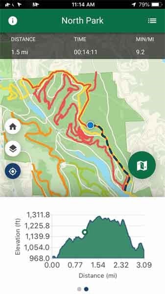
- A breadcrumb feature that tracks the user’s path, total distance, and minutes per mile. Users can start recording their hike whenever they want, even from the parking lot at the park or trailhead. They simply click the record button to begin tracking their hike. They can choose to pause or reset the recording at any time.
Reams communicated these requirements to Esri UI/UX designer Kevin Gao to create a user-friendly design. With the goal of creating an ideal user experience, Reams used the user interface designs and high-fidelity mock-ups to develop the app using the latest version of ArcGIS Runtime SDK for Qt to take advantage of the updated and modernized API.
In addition to AppStudio for ArcGIS, the GIS team used ArcGIS Pro to author and publish a custom basemap and ArcGIS Online to host trails and other datasets used within the app.
“Of all the apps that I’ve worked on, the trails app has been the most exciting. Eli and Melinda were especially wonderful to work with,” said Reams. “Our working relationship made developing the app seem more like a team effort rather than the typical client/contractor engagement.”
The new mobile app has had several tangible benefits, including making it easy for parkgoers to locate high-resolution trail maps with their smartphone. Using the list view of each park or an interactive map view of Allegheny County, a parkgoer can select a park such as North Park, then click on a trail to get its name—North Ridge Trail, for example—see that the trail is difficult to traverse, and then choose one of three basemaps—the custom Allegheny County basemap, topography or satellite imagery—to view the map.
Prior to the development of this app, static PDF trail maps were created by the GIS team, uploaded to the Allegheny County Parks website, and downloaded by each user. The PDF maps made it difficult for hikers to navigate trails, particularly because there are so many near each other. So the app has substantially improved [the] user experience, Thomas said.
The app has also improved safety for trail-goers by utilizing real-time updates. Allegheny County park rangers can notify Thomas and the GIS team if something potentially dangerous occurs, such as rain storms or blizzards, and a trail must be closed. For example, in 2018, higher than usual rainfall caused multiple landslides and downed trees in the parks, said Thomas. As such, being able to reroute hikers and close impacted trails has been very beneficial.
When park rangers notify the GIS team that a trail must be closed, the GIS team edits the trail dataset in a relational geodatabase using ArcMap, overwriting the feature service’s ArcGIS Online REST endpoint—a resource accessed by a URL. Since this URL is hardcoded in the app, the user can see this change immediately. This allows Thomas and his team to update the trails in real time without having to republish the entire Allegheny County Trail app.
“The park rangers are big proponents of the app and are great at communicating with us. They help us maintain all of the data that goes into it to help keep hikers safe,” Thomas said.
Reams believes the app, and the technology behind it, have the potential for widespread use. “I definitely see this app as something that Esri could turn into a template to use for other city and county parks and recreation departments. [At Esri] we have had discussions about turning the app into a configurable template,” said Reams. “I hope others are able to implement it and have similar success.”
Thomas believes the app has resulted in increased use of the parks, which is an important goal for Allegheny County. “The app has attracted new groups to the park and has generated a lot of visitors. By and large, it has been all positive feedback,” he said. “The goal [of this app] is to get people out in our beautiful county parks and start exploring. I think it’s really built for the citizens of Allegheny County.”
About the author