To solve some of the problems the world faces today will require a greater emphasis on information sharing among organizations and with the public.
That’s beginning to happen, according to Esri president Jack Dangermond, who spoke about the contributions that ArcGIS users in every corner of the world are making toward the effort during his Plenary Session presentation at the 2020 Esri User Conference.
Users are sharing millions of datasets and creating billions of maps. “Your collective work is starting to emerge as a kind of global GIS,” Dangermond said.

The time, however, has come to share the information more widely and use it to achieve greater things.
That process began several years ago when Esri began collaborating with what Dangermond described as a loosely connected network of organizations, including Microsoft, the United Nations (UN), the National Geographic Society, and the E.O. Wilson Biodiversity Foundation.
This consortium will create and share digital experiences for a variety of communities, focusing on conservation, biodiversity, earth science modeling, global sustainability, geodesign, education, and public status reporting.
These digital experiences will be easier to work with than traditional GIS technology has historically been, according to Dangermond.
“Everyone wants easier technology,” he said, adding that it’s something that Esri is making progress on. “But we need to make a dramatic jump if we are going to transform the world with the kind of holism that so many of you appreciate.”
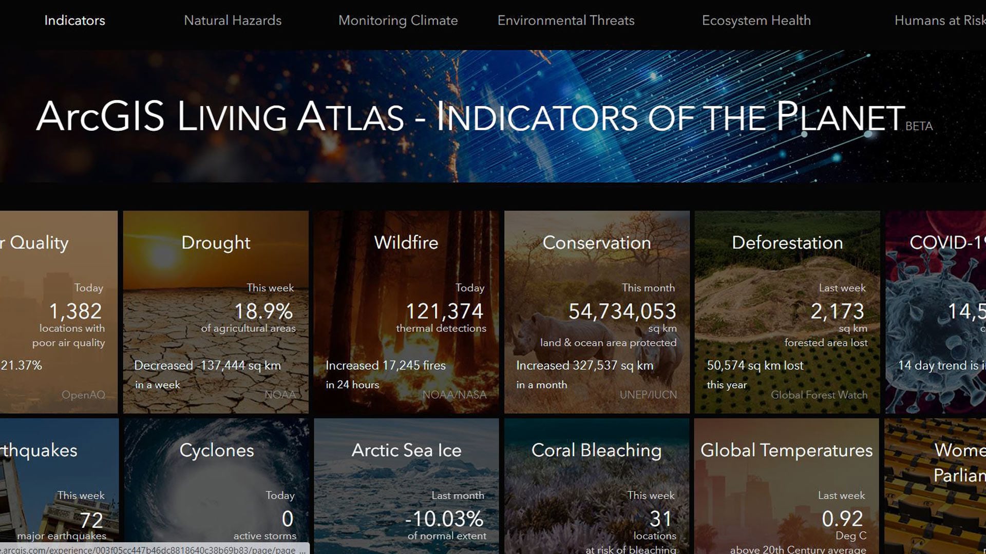
ArcGIS Living Atlas—Indicators of the Planet serves as one example of an engaging digital experience that Esri has recently built.
The app, created using ArcGIS Experience Builder cards, displays recent data on the planet’s health and safety—indicators such as drought, air quality, COVID-19 cases, sea level rise, deforestation, and armed conflict. The names of the organizations that contribute data are listed in the app.
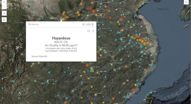
People can click on points on the interactive maps to see, for example, the latest air quality and deforestation information from around the world. Esri technology evangelist Bern Szukalski demonstrated the app for the Plenary Session audience.
The Indicators of the Planet app is a new addition to the Living Atlas.
“Anyone can go to look at these key global indicators and see [their] current status and conditions,” Szukalski said.
Organizations including the National Oceanic and Atmospheric Administration (NOAA), the United States Geological Survey (USGS), Johns Hopkins University (JHU), and Esri share their knowledge and content and provide additional resources to help people learn more.
There is a wide variety of information about the planet available in ArcGIS Living Atlas—Indicators of the Planet.
“Each of these cards focuses on a particular topic and is powered by Living Atlas content, which means it’s curated, and it’s authoritative, and it’s updated continually,” Szukalski said.
Some content updates daily, weekly, or at other intervals.
The template can be customized for any organization’s topics. The cards let users capture additional resources too. In the case of the Living Atlas—Indicators of the Planet app, there are links in some of the cards to ArcGIS StoryMaps and Learn ArcGIS lessons.
“This represents a new way for us to share geographic knowledge,” said Szukalski.
City, state, or federal government organizations, university research centers, or conservation organizations can focus on topics of importance to their mission, according to Szukalski.
“You [can] create sites to inform others, drive policy, and make better decisions,” he said.
Telling Stories about the Changing Planet
The National Geographic Society also is involved in creating new digital experiences. The organization is starting to use a global GIS platform to tell stories about how the planet is changing with an emphasis on educating youth and supporting the society’s conservation efforts and science and exploration programs.
Speaking at the Plenary Session on the topic of education was Vicki Phillips, executive vice president and chief education officer of the National Geographic Society. In her presentation, she briefed the audience about the National Geographic Society’s new education strategy, which is built on the premise that young people and educators are critical to finding solutions to the planet’s most pressing problems.
Phillips said the National Geographic Society wants to cultivate empathy for the earth among 100 million young people and cultivate leadership among 5 million youth over the next 10 years.

The National Geographic Society refers to the leaders in this group as #GenGeo. (Learn more about #GenGeo in this blog post written by Phillips.)
Another component of the National Geographic Society’s education program is to equip 2.5 million educators with what Phillips called “game-changing content and tools”—science, social studies, and geography content delivered anywhere, anytime, and on any device.
Geography is a science suited to solving the problems of the 21st century, according to Phillips. “We want to give young people a much more modern view of what geography is all about,” she said.
The strategy’s third prong is to increase geographic knowledge among educators and youth. So, the National Geographic Society and Esri have partnered to educate millions of students about geography and how to use it to problem solve.
“One thing we want to do together is fuel young people’s curiosity and give them that explorer’s mind-set,” Phillips said.
By honing their geographic and geospatial skills, they will learn to detect patterns in data, make informed decisions, and devise innovative solutions to problems facing us, according to Phillips.
MapMaker Interactive is an application that the National Geographic Society has collaborated on with Esri.
“People might [view] it as an on-ramp to GIS,” Phillips said, as it is a free mapping tool that can be used by itself or within a curriculum.
The National Geographic Society also plans to design sophisticated learning tools for educators that will help them develop geospatial skills.
Riley Peake, team lead for Learn ArcGIS at Esri, highlighted several no-cost resources for classroom and home learning environments that teams from the National Geographic Society and Esri have designed.
These resources will be hosted both on the National Geographic Society’s Education Resource Library and the Esri websites. They include 20 activities for addressing and understanding climate change; ArcGIS Online SkillBuilder activities, such as how to use the measure tool; ArcGIS StoryMaps apps; and access to the beta site Teach with GIS.
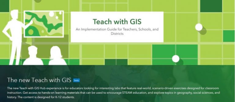
Teach for GIS includes teacher testimonials, ready-made teaching tools, student and teacher training materials, as well as Esri’s National Geographic collaboration resources.
On the NatGeo Collaboration page, Peake said you can find videos and lessons for creating, for example, an elevation profile of journalist Paul Salopek’s trek across South Asia. Or you can follow the lead of wildlife ecologist Rae Wynn-Grant and make a map of black bears to predict human interaction with them.
Phillips and Dangermond said they were impressed by the resources that have been created so far for students and educators who want to use interactive geospatial technology to explore and solve real-world problems.
“[These tools] are going to allow educators to help young people have the knowledge and skills they need to act with urgency and be the architects of change.”
A Network for Sustainable Development
Another group that is well equipped to help build solutions to the world’s most pressing problems is GIS users.
In a second Plenary Session discussion, this time with Jeffrey Sachs, president of the UN Sustainable Development Solutions Network (SDSN) and director of the Center for Sustainable Development at Columbia University, Dangermond highlighted how the business community—and GIS professionals and geographers more specifically—have the expertise and tools needed to make the UN Sustainable Development Goals (SDGs) come alive.
“We need a big change of direction on the planet,” Sachs said.

The 8 billion people on the planet deserve and need safe water, nutritious food, and a healthy environment, according to Sachs.
“They’re not getting that,” he said, citing human-induced climate change, megapollution, the destruction of biodiversity, and an extremely wide and growing economic gap between the rich and the poor.
These global issues are what the SDGs—the only globally agreed-on and shared goals—aim to tackle. To support the work that’s being done to achieve them, Sachs developed the SDSN, which brings together academic and thought leaders, scientists, universities, and now the business community to create practical solutions. The newly launched SDGs Today website, built as a partnership between the SDSN and Esri, supports this by aggregating relevant real-time data from around the world.
Dan Pisut, the environment content team lead for ArcGIS Living Atlas of the World, demonstrated the SDGs Today website. Using cards like the ones Szukalski used in his demonstration, Pisut showed how the desert locust crisis happening in eastern Africa, combined with precipitation that’s causing major flooding, has greatly affected recent crops and is contributing to food insecurity in the area.
“Through GIS, SDSN is able to take complex topics and simplify them into a summary statistic or offer all the geospatial detail—in essence, providing both the forest and the trees,” said Pisut.
Sachs and his partners hope that the GIS community will start contributing data to the SDGs Today website and expand the number of topics it covers.
“I want people to look at these goals and the targets that go along with them and ask the question, ‘OK, how can this be done? How can I contribute to the solution?'” Sachs said. “We need networks to do this.”