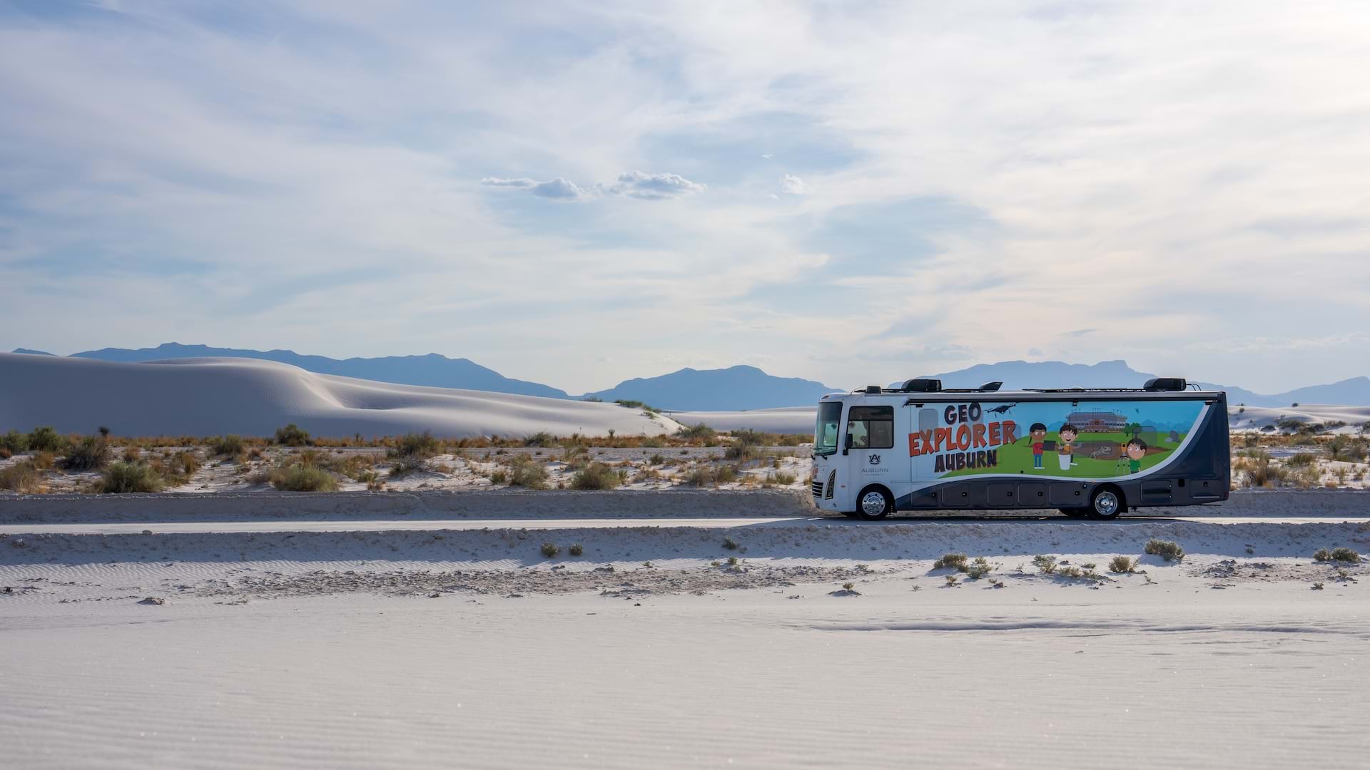
Across the US, students from kindergarten through 12th grade (K–12) rarely encounter a dedicated geography or geoscience class in school. In Alabama, that changes when a 35-foot solar-powered RV called Geo Explorer Auburn pulls up to campus. Once the door swings open, students step into a mobile lab filled with glowing touch screens, virtual reality safaris, and interactive sandboxes. Concepts like topography, soil types, and severe weather shift from abstract to hands-on, transforming how students understand the world around them.
“We want that big-time experience where you cannot forget it; that fourth, fifth, sixth grade level is where people develop their science identities,” explained Timothy Hawthorne, professor and chair of the Department of Geosciences at Auburn University and founder of Geo Explorer Auburn.
Created by Hawthorne and his team at Auburn’s College of Sciences and Mathematics, this mobile science lab expands the reach and impact of geoscience education to K–12 students, especially those in under-resourced schools.
After a soft launch in spring 2025 that reached more than 1,000 students and families, Geo Explorer Auburn officially began its journey in September. With a curriculum aligned to Alabama state standards and the Next Generation Science Standards (K–12 science content standards), Geo Explorer Auburn combines geoscience and geospatial technologies to immerse students in the science of place—making complex concepts tangible, relevant, and engaging.
A Mission Rooted in Access and Identity
According to the American Association of Geographers, as of the 2022–2023 school year, only four states require a stand-alone middle school geography course, and just three require it for high school graduation. In most states, geography is folded into general social studies or omitted entirely, leaving students with limited exposure to geographic thinking.
Geo Explorer Auburn helps close that gap. Hawthorne’s personal experience and community-based research shaped a belief that science education should meet students where they are.
“People in academia can do more to get out and about in society,” he said. “Something like this is designed to get out into and work with the community to better science and technology learning experiences.”

As a land-grant university, or an institution that receives federal land or funding to provide education, Auburn University fulfills its mission with the mobile lab by removing cost barriers, connecting students with local universities, and opening pathways to geoscience careers.
By visiting K–12 schools across Alabama, the lab delivers an experience that sparks curiosity and builds confidence in students who might not otherwise see themselves in science, technology, engineering, and mathematics (STEM) fields.
Where Exploration Meets Experience
The Geo Explorer mobile lab is built around three guiding questions that help students connect local observations to broader scientific themes:
- Which Earth systems are involved—biosphere, atmosphere, hydrosphere, or geosphere?
- What is the geographic scale: local, national, or global?
- How do humans interact with and adapt to their environments?
These questions shape every activity inside the lab. Students work in small teams and rotate through stations in 15-minute blocks, engaging with geoscience concepts in ways that are hands-on, collaborative, and tailored to each school’s needs. Each station is designed to explore one or more aspects of the guiding questions, turning abstract ideas into tangible experiences.
VR headsets, for example, let students explore global landscapes—from reef dives to safaris.
“Not all kids leave their city,” Hawthorne said. “Seeing an elephant in its habitat sparks that explorer mindset.”
The RV’s former kitchen was repurposed into a microscope lab with four scopes for examining sand samples from around the world. The team plans to expand this station by incorporating digital stories on the samples using ArcGIS StoryMaps. Another station includes a 3D printer producing models of fossils, state outlines, and landscape contours.
What had once been a bedroom became the most popular station: the augmented reality sandbox. Using a projector and motion sensor, students manipulate the sand to visualize elevation and contour lines as an introduction to topographic mapping.

“Students shape the landscape with their hands and instantly see a digital interpretation,” Hawthorne explained. “Build a mountain, and the contours rise. Carve a river, and it turns blue and flows downhill.”
Nearby, a bathroom was converted into an extreme weather experience, nicknamed the “tornado tunnel,” which focuses on emergency preparedness. With gusting winds and flashing lights, it has become a favorite. But beyond the excitement, it sparks deeper conversations. Geo Explorer staff encourage students to take what they learn home, prompting family discussions like, “What should we do if a tornado hits?”
Outside, drone demonstrations show how field data is collected and processed using tools like ArcGIS Drone2Map. Staff from Auburn share real-world fieldwork—such as mapping Mayan temples or coral reefs—to show how these experiences translate into careers.
“We get paid to do this kind of field research, and that gets students excited,” Hawthorne said.
In the future, the RV will have an attached trailer where students will explore sustainable agriculture through grid-based planting and robotics.

The response from students has been positive. One fifth grader arrived with a personal rock collection, eager to see how her amethyst glowed under UV light. Another left inspired to pursue science and engineering in college. A third was so taken by the augmented reality sandbox, they worked with their parent-teacher association to fund one for their school.
A Framework for the Future
What began as a concept in December 2024 became a fully operational mobile lab by spring 2025—a rapid turnaround made possible by a collaborative effort. Auburn University’s Department of Geosciences led the retrofitting process. Recreational vehicle partner Bama RV in Opelika, Alabama, provided mechanical support. Solar energy partner 15 Lightyears in Longwood, Florida, donated and installed the rooftop panels.
“[The] key to this was bringing the right people together,” Hawthorne said. “Every team member had a unique set of skills.”
With the lab on the road, the team focused on making it fit seamlessly into the school day. The program includes assessments before and after to measure student learning outcomes. Local educators helped shape lesson plans that align with state standards and classroom needs.
“If you’re a teacher and we come to your school, we can tell you exactly what concept they’re learning in the state standards and what they learned that day,” he said.
This blend of immersive engagement and measurable impact has made Geo Explorer Auburn a model for replicable STEM education. Hawthorne and his team aim to build 10 mobile labs over the next five years, with the next one intended to travel to schools in Belize in partnership with the University of Belize.
“There are so many things that matter to kids,” Hawthorne said. “We just need to ask the right questions. This gives them space to explore and to ask the bigger questions that matter to them.”
Learn more about Geo Explorer Auburn and its mission at geoexplorerlabs.org.
Note: Esri supports K–12 education with mapping software, ready-to-use activities, and other resources for teaching with GIS.