Thrive Regional Partnership Uses Geodesign Methods and Technology to Plan a Sustainable Future
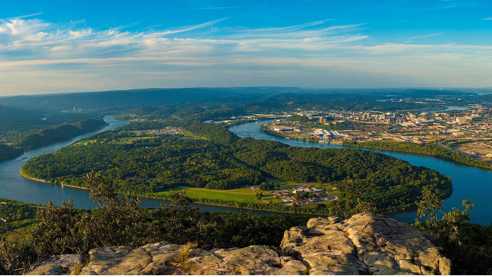
Chattanooga, Tennessee, and the surrounding region have some of the best outdoor recreation areas in the southern United States. The area is also a hub for startups that have grabbed the attention of big business. The local Amazon Fulfillment Center and Volkswagen’s assembly plant have brought in thousands of jobs. With the population growing, the number of visits to scenic vistas such as the Tennessee River Gorge and Lookout Mountain have gone up. Traffic also has increased on the area’s trail networks. To sustain the region’s natural treasures—from trails to caves and forests to wetlands—local organizations work together using a geodesign approach to plan the conservation of these areas.
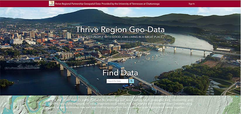
The University of Tennessee at Chattanooga Interdisciplinary Geospatial Technology Lab (IGTLab) is assisting in this effort, providing the nonprofit Thrive Regional Partnership and its stakeholders with the publicly available Thrive Region Geo-Data online platform for open data, analysis, and design, which is powered by Esri ArcGIS.
IGTLab uses ArcGIS as the framework for understanding the land’s ability to serve the growing community in a sustainable way as it practices geodesign. Geodesign combines stakeholder input, creative design techniques, rigorous methodologies and spatial analysis and mapping to find the most suitable, environmentally-friendly and sustainable options for how to use space.

With the Thrive Region Geo-Data online platform, an ArcGIS Hub site, IGTLab provides the data and web maps and apps that give Thrive, its partners, and the public the tools needed to analyze information on trails, waterways, wildlife corridors, endangered species, wetlands, transportation, water quality, agriculture, demographics and more.
Thrive promotes smart, responsible growth in the tri-state Chattanooga region, focusing on economic development, education, transportation, and conservation. To create conservation goals for the region, Thrive formed the Natural Treasures Alliance. This alliance is composed of over 40 entities including local governments; conservation, outdoor recreation, tourism, and philanthropic groups; and nongovernmental organizations (NGOs) such as The Trust for Public Land, Open Space Institute, and The Nature Conservancy. The alliance works to ensure that future generations can access healthy forests, clean water, wholesome food, and green spaces.
Along with the Natural Treasures Alliance, Thrive Regional Partnership—an NGO itself—facilitates a citizen-led, multifaceted planning approach that considers economic development and ecological factors for regional improvement. The goal is to create a region where human and natural systems thrive together.
For geospatial expertise, Thrive turned to IGTLab, which recommended that Thrive use geodesign methodology and technology to plan projects. In this multidisciplinary approach, organizations that are typically siloed work together and use GIS technology to set goals, plan, and prioritize land use. The technology includes maps for exploring sustainable options, and tools for scientific spatial analysis and creative design.
“Using a geodesign approach, we enlist geospatial technology through our partnership with the University of Tennessee at Chattanooga’s IGTLab to plan and monitor projects that will sustain responsible and inspired growth of the greater Chattanooga region’s green infrastructure for years and generations to come,” said Bridgett Massengill, Thrive Regional Partnership president and CEO.
Starting the Geodesign Process and Creating the Online Platform
Over the past 15 years, IGTLab has provided geospatial services to land trust NGOs, the National Park Service (NPS), the Tennessee Valley Authority, and other agencies within the 16-county Chattanooga region and beyond. IGTLab has helped organizations conserve land, build greenways, and promote green infrastructure. Furthermore, the staff’s expertise and relationships with partners have served to expand Thrive’s model of collaborative, informed decision-making when it comes to regional growth.
To implement environmental stewardship on a regional scale, IGTLab played a part in devising a strategy that would help Thrive Regional Partnership and the Natural Treasures Alliance use spatial analysis to guide project design and monitor progress toward achieving long-term environmental goals.
The first step in the geodesign process was to bring people together to talk about what kind of data was required. During this process, Thrive’s Natural Treasures Alliance decided it needed to know how much land in the Chattanooga region had been protected in the past and could be protected in the future. Participants at the meetings represented local grassroots organizations, large national conservation groups, and businesses interested in conservation. They discussed priorities, including the need to preserve farmland, habitat, and water quality and to promote outdoor recreation, which improves community health and contributes greatly to local economies.
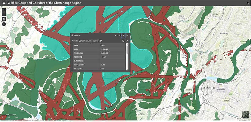
Participants asked for data and apps to map land use and requested models that showed water quality and flow. High on the wish list were corridor analysis tools to help design networks that preserve biodiversity.
IGTLab fulfilled the requests, launching the Thrive Region Geo-Data site two and a half years ago. The site is a repository for a variety of data but also includes models of wildlife cores and corridors and ready-to-use web applications.
Visitors to the site can select a dataset on mountain bike trails, for example—click to create a web map, and the trails will display. Smart mapping capabilities in ArcGIS Online can then be used to style the map—for instance, change the color of the trails or display different attributes such as trail length or difficulty.
“IGTLab keeps a database of protected lands, trails, and access points of the region to ultimately track how much and how fast the region is conserving land,” said IGTLab director Charlie Mix, who is assisted by University of Tennessee graduate and undergraduate students on Thrive-related projects. “We develop models, maps, and tools defined by the organizations that do the work of conserving land, protecting habitat biodiversity, and promoting biodiversity. We host the models on ArcGIS Online so that partners can access the data and integrate it into their own work.”
Telling Stories about Art, Culture, and Conservation with Esri Story Maps Apps
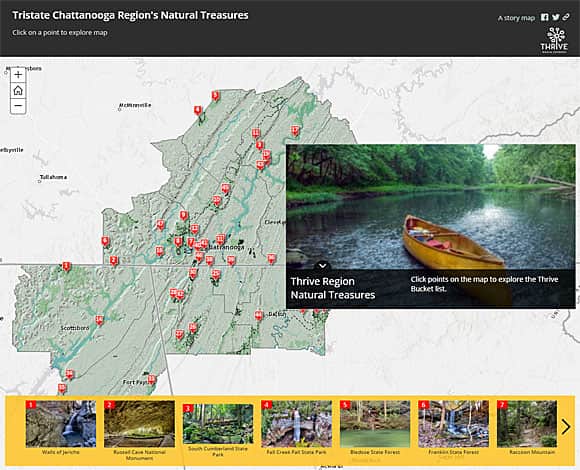
IGTLab used Esri Story Maps configurable app templates to create several story maps for the Thrive Region Geo-Data site, including one called Chattanooga Region’s Natural Treasures. People can take an online tour of 47 scenic and historic locations such as Buck’s Pocket State Park, McLemore Cove, Bledsoe State Forest, Raccoon Mountain, and the Pinhoti National Recreation Trail.
Another story map on Thrive’s site, Thriving Communities, shows how arts, recreation, and cultural assets—in towns such as Fort Payne, Alabama; Dalton, Georgia; and Ducktown, Tennessee—can spur economic development.
Thrive also published A Watershed Moment, a story map that illustrates how the region’s watershed influences cities, rivers and waterfalls, wildlife management, and national monuments. The story map includes an embedded Esri Story Maps Swipe app that lets users analyze and compare land-cover change over time.
Other projects that IGTLab has created for Thrive include an analysis of forest loss, which was published in a story map, and an outdoor recreation map of the greater Chattanooga area.
Assessing Green Infrastructure
Geospatial visualization and analysis continue to play a role in the green design of the region.
IGTLab used Esri green infrastructure collection of resources, available via ArcGIS Living Atlas of the World, to find conservation opportunities in the Chattanooga area. Esri created data and tools to help agencies analyze habitats such as those found in an unfragmented natural area (also known as a core). First, the IGTLab team accessed the Green Infrastructure Core national dataset to see priority habitat areas consisting of 100 acres or more. Next, the team used the Green Infrastructure Center Model for ArcGIS Desktop to customize the dataset for the Chattanooga region to display local habitat data at more than 25 acres. View the dataset.
The Land Trust for Tennessee, a key partner in the Thrive Regional Partnership, works with landowners to create conservation easements. Using GeoPlanner for ArcGIS, IGTLab created an app that scores and maps an area’s parcels for conservation suitability. Datasets for this model include habitat cores, corridors, water quality, working lands and agriculture, and climate resilience. To see a parcel’s conservation suitability score, the user simply clicks on the parcel’s location. The Land Trust uses the parcel suitability app to screen potential projects. Agencies can easily access and interpret data and do their own spatial analysis to help them prioritize their projects.
On a larger scale, IGTLab is helping the Cumberland Trails Conference plan connections from the Cumberland Trail to other existing trail systems and communities along the Cumberland Plateau. A major component of the Great Eastern Trail, the 300-mile Cumberland Trail cuts north and south across Tennessee, starting in Chattanooga and ending near the Tennessee-Kentucky border at Cumberland Gap National Historical Park. Once completed, the Great Eastern Trail will provide hikers with an alternative to the relatively crowded Appalachian Trail.
By using geodesign to support green infrastructure planning, Thrive and its partners have committed to collaborative planning approaches to sustain the natural assets of the greater Chattanooga region for generations to come.

