A hands-on website and a print book for seasoned GIS practitioners and newcomers to GIS
Consumer mapping has opened the eyes of the world, and especially decision makers, to the value of maps and geography and consequently increased the demand for the critical information and insights generated by GIS. This phenomenon is also transforming the role of GIS practitioners. Today, they need to better understand their organization’s business objectives so they can contribute in an even more meaningful way to its success. ArcGIS is a complete system for discovering, creating, consuming, and sharing geographic data, maps, and apps. It is a true Web GIS. Web GIS is fundamentally changing how information about the world around us is applied and shared to enable all of us to make the best decisions possible. Whether you’re a seasoned GIS practitioner or a newcomer to the field, you have a new way to experience Web GIS for yourself. This is the promise of The ArcGIS Book.
Cover image courtesy of Stamen Design.
The ArcGIS Book explores Web GIS in ten chapters, each focused on one big idea. You will learn how to do new things with GIS and accomplish familiar tasks more quickly and easily. For inspiration on what you can do with Web GIS, the book includes links to hundreds of live examples of web maps and apps as well as videos of thought leaders sharing their vision for what you can accomplish by adopting the Web GIS concepts.

In addition to inspiring you, The ArcGIS Book will give you hands-on practice with making a story map, conducting spatial analysis, editing geographic data, building a 3D model, and much more. Here are the ten big ideas explored in the book:
- Maps, the Web, and You: Power and possibility with Web GIS
- Cartography is for Everyone: New ways to make, see, and use maps
- Tell Your Story Using a Map: Inform, engage, and inspire people with story maps
- Great Maps Need Great Data: Creating and using authoritative geographic data
- The Importance of Where: How spatial analysis leads to insight
- Mapping the Third Dimension: A change in perspective
- The Power of Apps: Focused tools that get work done
- Your Mobile GIS: The GIS of the whole world plus a live data sensor in your pocket
- Real-Time Dashboards: Integrating live data feeds for managing operations
- GIS is Social: Web GIS is the GIS of the world
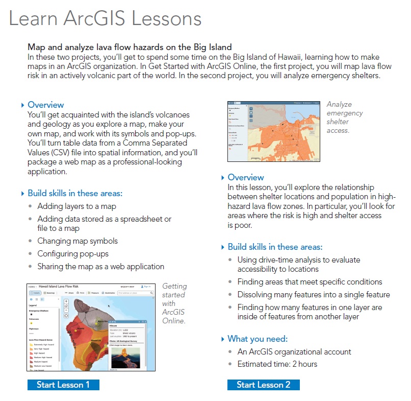
In each chapter, Quickstarts tell you what you need to know about the software, data, and web resources that pertain to that aspect of the ArcGIS system. The Learn ArcGIS Lessons pages are your gateways to online, hands-on tutorials from the Learn ArcGIS website.
The intended audience for The ArcGIS Book is diverse: from GIS professionals expanding into online mapping to information workers in every field who recognize the power of maps to communicate information clearly. No matter which group you identify with, we encourage you to share this book with your colleagues, decision makers in your organization and your community, and young people in your line of work and in your family. Introduce them to and help them explore the power of Web GIS for sound decision making. Over the next several weeks we will share a series of blog posts that highlight each chapter in the book. So stay tuned. The ArcGIS Book is available in print, as a downloadable pdf, and as an interactive website. See it come alive at www.TheArcGISBook.com.

Article Discussion: