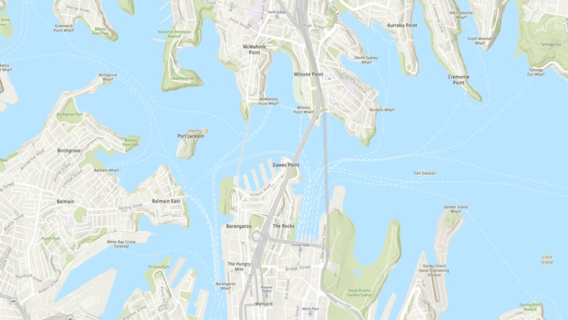
Featured Article
Bern Szukalski | Aug 30, 2023
Tips and techniques to minimize credit consumption when using analysis tools.
Multiple Authors | September 14, 2023
Updated data from the Watershed Boundary Dataset (WBD) now in Living Atlas.
Multiple Authors | September 14, 2023
Edit and customize base labels and blur the lines of what's possible with a basemap...
Shane Matthews | September 13, 2023
Ever wonder what happens when your organization submits map layers to Esri Community Maps Program?
Bern Szukalski | August 28, 2023
How to make a hurricane map in a minute (maybe less) using ArcGIS Online and ArcGIS Living Atlas of the World.
Alix Vézina | August 23, 2023
Use the Elevation Profile widget to evaluate the intensity and technicality of a route by examining the elevation changes.
Christie Roland | August 23, 2023
Dive into the ArcGIS Survey123 team's curated picks from the 2023 Esri User Conference. Learn new tools and tips to help elevate your work.
Gina Girgente | August 23, 2023
Create spatial and attribute queries all in one new tool in Map Viewer: Find by Attributes and Location.
Multiple Authors | August 23, 2023
App enhancements and updated demographics help to increase your awareness during fire season.
Gregory Ponto | August 18, 2023
Customers that have configured the SAML options "Enabled Signed Requests" or "Encrypt Assertion" must update their ArcGIS Online metadata file.
Gina Girgente | August 16, 2023
There are multiple ways of creating subsets of data for analysis, but which one is best? Explore the options for Map Viewer here.
Quentin Andersen | August 10, 2023
Find out how far electric vehicles can travel from a charging station before they need to recharge.
Ryan Farmer | August 10, 2023
Here's a bit of a mind shift on how we can extend the reach of our GIS within our organizations.
Multiple Authors | August 9, 2023
Understand the differences between ArcGIS Enterprise and ArcGIS Online and how they work together.
Bern Szukalski | August 8, 2023
An auto-rotating globe is a fascinating way to view our planet. Make your own in a minute, maybe less, using ArcGIS Online and Living Atlas.
Multiple Authors | August 2, 2023
ArcGIS Image for ArcGIS Online allows you to host multidimensional imagery for visualization or analysis through out your organization.
Bern Szukalski | August 1, 2023
How to make a sea temperature and coral bleaching map in a minute (maybe less) using ArcGIS Online and ArcGIS Living Atlas.
Debapriya Paul | July 28, 2023
Learn how to engage with group layers, one layer at a time with exclusive visibility in Map Viewer.
Multiple Authors | July 26, 2023
Understand each app builder and how to select the right one, or more than one, based on your needs.
Shane Matthews | July 24, 2023
Your organization can enhance imagery in ArcGIS Online by contributing your recent, submeter-resolution imagery.
Russell Roberts | July 14, 2023
Learn how to aggregate your data with bins in Map Viewer.
Kathy Cappelli Breier | July 11, 2023
Taking over administration of an ArcGIS Online organization has never been easier! Use this checklist to get oriented.
Eunan Gillen | July 7, 2023
Learn how to edit your project feature service to create unique symbology for ArcGIS GeoBIM maps and scenes.
Heather Smith | July 6, 2023
Before you share a web map, take a few minutes to confirm that it’s ready to share.
Multiple Authors | July 5, 2023
The StoryMaps team and Joshua Stevens discuss the state of science communication, storytelling, maps, and everything in between.
Multiple Authors | July 3, 2023
Learn more about 3D GIS and Digital Twins at the 2023 Esri User Conference, which takes place on July 11-14, 2023.