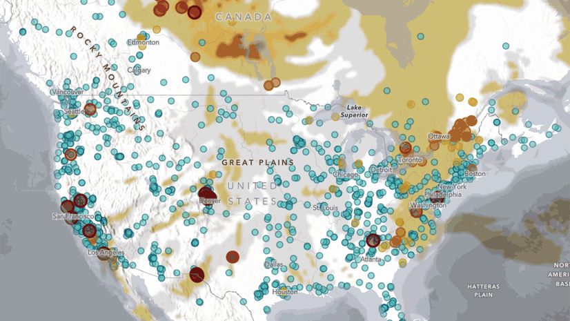
Featured Article
Diana Lavery | Aug 07, 2020
One more resource in ArcGIS Living Atlas to support your work: a data layer and web map of historically redlined neighborhoods.
Lisa Berry | September 21, 2020
Esri Maps for Public Policy offers tools and maps to help tackle the world's biggest problems. Check out 5 maps that give us a look into how.
John Nelson | September 21, 2020
How to replicate this charming projection effect in ArcGIS Pro
Dan Pisut | September 18, 2020
A new application provides near real-time EPA air quality data along with potential demographic impacts for the USA.
Gonzalo Espinoza | September 18, 2020
Expedite the setup of a hydro project using Living Atlas layers.
Bern Szukalski | September 17, 2020
How to make a flood map in a minute (maybe less) using ArcGIS Online and ArcGIS Living Atlas.
Lisa Berry | September 15, 2020
Take 5 minutes for a quick Tour of the Esri Maps for Public Policy Site. Learn how to use maps to help inform public policy.
Multiple Authors | September 14, 2020
Data shows that hurricanes are increasingly intense and more frequent. Understand how to visualize large spatiotemporal datasets using 3D.
Julia Holtzclaw | September 11, 2020
Wildfire Hazard Potential Enriched with Demographics now in ArcGIS Living Atlas
Robert Jensen | September 9, 2020
Esri hosts multiple raster basemap services that will enter Mature Support next year.
Bern Szukalski | September 7, 2020
How to make a smoke forecast and air quality map in a minute (maybe less) using ArcGIS Online and ArcGIS Living Atlas.
John Nelson | September 4, 2020
What's a sparkline? Where did this idea come from? What insights are in it?
Andrew Green | September 2, 2020
Topographic (with Contours) is a new map style for Map Viewer Beta. It contains a multisource tile layer pointing to two hosted vector layers.
John Nelson | August 31, 2020
CovidPulse visualizes the rates of COVID-19 cases, and deaths, in the United States, as compact trend lines. Updated daily.
Rich Nauman | August 28, 2020
An exciting new biodiversity layer from the Half Earth Project provide a great example of the blending tools in the new Map Viewer.
Lisa Berry | August 25, 2020
ArcGIS Living Atlas now contains global air quality content derived from 19 years of NASA SEDAC data. See how air quality has changed over time.
Bern Szukalski | August 24, 2020
How to make a hurricane map in a minute (maybe less) using ArcGIS Online and ArcGIS Living Atlas of the World.
Multiple Authors | August 21, 2020
Public information map and app for viewing and sharing wildfire data.
Julia Holtzclaw | August 21, 2020
141 years of historical fire perimeter data for California now updated to include the latest 2019 fire records.
Gonzalo Espinoza | August 13, 2020
Explore how Live Feeds drive updates for Living Atlas Indicators of the Planet and the online resources available to implement your own routines
Andy Skinner | August 6, 2020
The blending tools in Map Viewer Beta are offering many new opportunities for rendering maps … and resurrecting some old ones.
Kyle R. Cassal | August 6, 2020
Census 2010 Demonstration Products allow data users to see how Census 2010 data would look with differential privacy applied to it.
John Nelson | August 6, 2020
Sometimes all that extra map is just extra. Here's how to use a blend mode to show only what you want.
Bern Szukalski | August 4, 2020
Use ArcGIS Living Atlas Recent Earthquakes layer with ArcGIS Online geoenrichment and analysis tools to learn more about the impacted population.
Bern Szukalski | August 3, 2020
How to make an earthquake map in a minute (maybe less) using ArcGIS Online and ArcGIS Living Atlas.
Bern Szukalski | August 3, 2020
How to make an earthquake map in a minute (maybe less) using ArcGIS Online and ArcGIS Living Atlas.