 Elevation analysis services, hosted by ArcGIS Online, are a new option for performing analyses that require elevation and hydrologic data. For example, you can find the slope of a road, calculate a viewshed, or discover where water flows to or from using these services in ArcGIS Online, ArcGIS for Desktop, or other web clients. If you would like to learn more about online elevation analysis, tune into the live training seminar Elevation Analysis with ArcGIS Online on June 5th, 2014.
After viewing this seminar, you will understand how to:
- Use terrain analysis tools to explore elevations along a particular path; identify visible areas; and calculate elevation, slope, and aspect for features that you select.
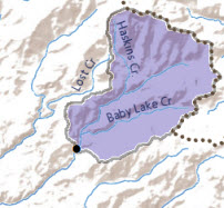
- Use hydrologic analysis tools to determine watersheds and the downstream path of water based on a point that you choose.
- Build custom web applications using the ArcGIS Online elevation analysis REST API, which is included in your ArcGIS Online organizational subscription.
This seminar will be of interest to GIS analysts who need to visualize terrain and perform raster-based analysis. ArcGIS Online users who want to work with elevation and hydrologic data, and developers who want to build web applications that consume elevation analysis services will also want to attend this seminar.


Article Discussion: