The ArcGIS Online World Geocoding service update that was released last night is not just another regular data update. It’s a major release with significant enhancements. This blog will guide you through some of the new features and improvements you can expect to see in the service. You can find a complete list of changes and detailed information about available functionality in the World Geocoding service documentation.
1. Geocoding in more countries – You can now search for addresses in more countries than before. Previously the World Geocoding service boasted support for address-level geocoding in 109 countries. The list has expanded to an even more impressive 135 countries. We’ve also updated the reference data for most countries and added new authoritative address data sources for Australia (G-NAF) and Austria (BEV).

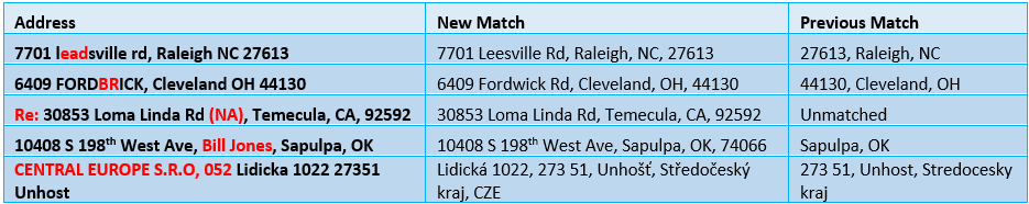
2. Improved matching logic – We’ve enhanced the behind-the-scenes matching logic for better handling of poorly-formed address searches. Geocoding in the USA consistently yields high match rates, but your address database may include questionable addresses with misspellings or extra information that can’t be geocoded, such as person names. The enhanced service is capable of handling this type of incorrect information. Below are a few examples of how these improvements can boost geocoding match rates even higher.
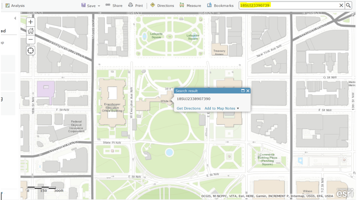
3. Enhanced coordinate search – Our Defense and Intel users have always been able to easily search for MGRS (Military Grid Reference System) coordinates in ArcGIS Desktop. Unfortunately it wasn’t so simple to do the same in ArcGIS Online. For the first time, you will be able to search for MGRS coordinates – along with postal codes, addresses, populated places, and points of interest – from a single endpoint in ArcGIS Online with the World Geocoding service. Additionally, you can now search for latitude/longitude coordinates in different formats, such as degrees-minutes-seconds (DMS), and can also find United State National Grid (USNG) coordinates.
4. More than addresses – Another useful feature in the updated service is the ability to batch geocode Point of Interest (POI) names. You may have tables that include both addresses and place names, and in the past when you tried to batch geocode them there were no matches for the place names. However, you could find the same place names with geosearch. There’s no longer such a disconnect because the enhanced geocoding service can now handle the same types of input for batch geocoding as it does for geosearch, which means you can batch geocode addresses, postal codes, and POIs, or any combination of these.
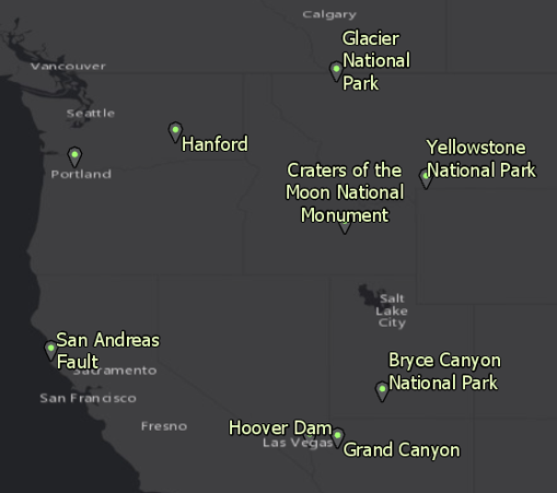
As an added bonus you can now combine POI names with addresses and postal codes in a single search. Overall the World Geocoding service allows more search flexibility than ever before.
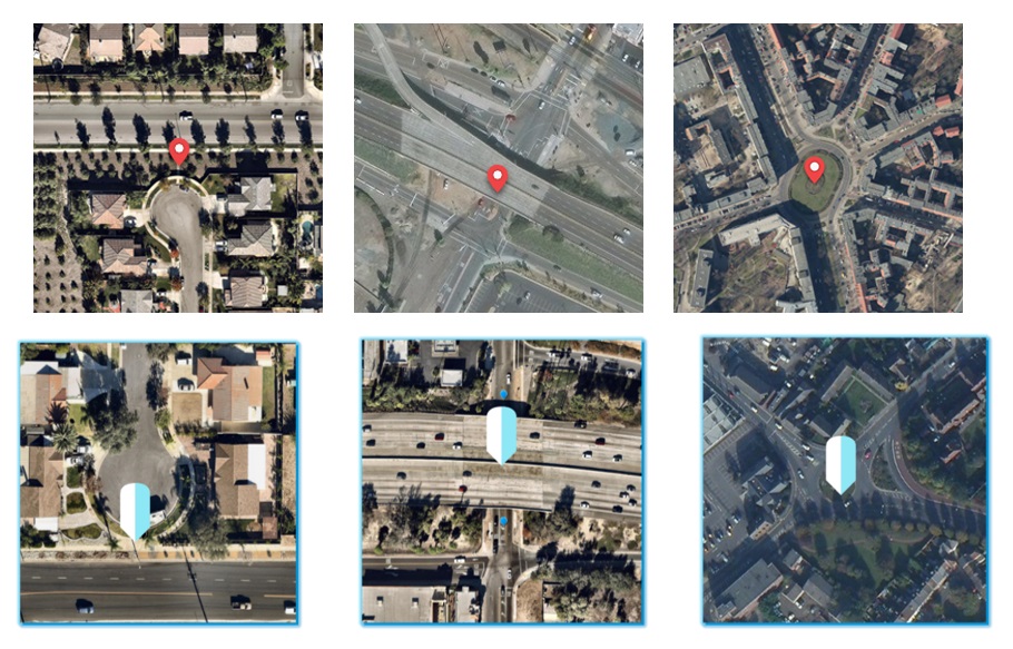
5. Improved intersection geocoding – With the updated service you’re no longer limited to finding intersections between streets that are physically connected. In many cases two streets may nearly intersect each other but are separated in some way. For example, a street ending in a cul-de-sac or dead end may be close to a cross street but separated from it by a walkway. A highway overpass is elevated above the road beneath it, so they cross each other but aren’t connected. The streets entering a roundabout intersect the roundabout itself but not each other. The World Geocoding service now has the ability to find intersection matches for each of these cases, and any scenario in general where two streets are close to each other but don’t actually intersect.
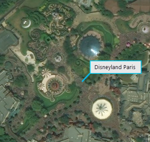
6. Enhanced reverse geocoding – In the past, reverse geocoding was the process of taking X/Y coordinates and converting them to an address or intersection. However, when you reverse geocode a location you’re really trying to find an answer to the question “What’s near me?”, or more specifically, “What’s near this location?” Sometimes the best answer to that question isn’t a street address. Maybe you see an interesting landmark on a map and you want find out what it is. Or maybe the spot you click on the map is far away from any streets and no address is returned, but you still want to know the city or postal code at that location. With the updated service you’ll always get a match to the most relevant feature near your location when you reverse geocode. It may be a restaurant, park, address, postal code, or city. For example, if you drop a point in the middle of Disneyland Paris that’s what the service will return.
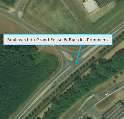
There may be situations where you only want the closest address or intersection to be returned for an input location, and the World Geocoding service supports this too. You can control which features are returned by using the new featureTypes parameter, available with the reverseGeocode operation through the service REST API. For instance, referring to the previous image, if you want the service to find an intersection instead of Disneyland Paris you can pass featureTypes=StreetInt in your reverseGeocode request and the service will return this:
You can find more details in the developer documentation.
7. Data refresh – The World Geocoding service will continue to be updated with new reference data at regular intervals, providing you with detailed global coverage using high-quality authoritative datasets. The service released last night was built with the most current available address data.
As you can see, the geocoding team has been working hard to deliver the best possible geocoding experience to you. Our work isn’t done though, as we’re planning additional improvements for subsequent releases in the near future, so stay tuned! We hope you’ll find these latest enhancements useful in your ArcGIS applications and projects.
If you have any feedback, please send it to GeocodeQA@esri.com, or stop by and chat with us at the User Conference in San Diego.
– The Geocoding team

Article Discussion: