ArcGIS Pro is used to build the maps and data analysis models you use throughout the ArcGIS platform. Here are some of the can’t miss sessions at the Esri Developer Summit for ArcGIS Pro.
ArcGIS Pro Area in the Esri Showcase
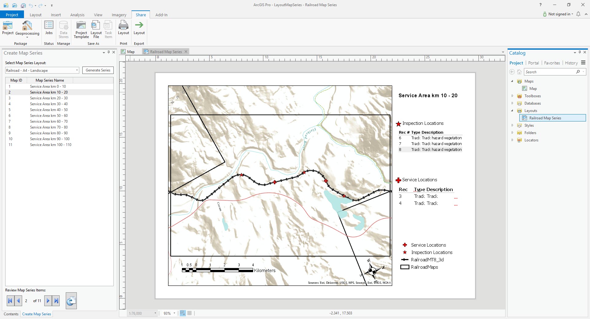
Visit the ArcGIS Pro area to talk to the product team about creating maps and analysis models, using geoprocessing tools, sharing your maps and scenes, and developing applications using Esri’s ArcGIS Pro SDK.
Esri Showcase Hours
| Day | Time |
|---|---|
| Monday, March 5 | 2:00 pm – 7:00 pm |
| Tuesday, March 6 | 12:00 pm – 6:30 pm |
| Wednesday, March 7 | 10:00 am – 6:30 pm |
| Thursday, March 8 | 9:00 am – 4:00 pm |
Featured Sessions
Getting Started with the ArcGIS Pro SDK for .NET
Thursday, March 8
9:00 am – 3:30 pm
Mojave Learning Center
This new hands-on training workshop will introduce you to ArcGIS Pro SDK concepts, helpful tips and practical steps to help you get started developing add-ins to extend ArcGIS Pro. Participants will walk through topics with the workshop instructor and then work through exercises using their own device with the Pro SDK and the Microsoft Visual Studio development environment.
Topics will include:
- Pro SDK overview, online resources and community samples
- Starting with DAML and UI customization
- Basic solution configuration development
- Working with common SDK patterns
This workshop is included free with your Esri Developer Summit registration.
Prerequisites: This course assumes that participants have basic experience developing Windows applications using Microsoft Visual Studio 2015 or 2017 and .NET, as well as a few months of experience working with ArcGIS Pro.
Workshop participants must bring their own device, pre-installed with ArcGIS Pro 2.1 and Microsoft Visual Studio 2015 or 2017.
ArcGIS Pro: The Road Ahead
| Tuesday, March 6 | Thursday, March 8 |
|---|---|
| 4:00 pm – 5:00 pm | 4:00 pm – 5:00 pm |
| Oasis 4 | Primrose B |
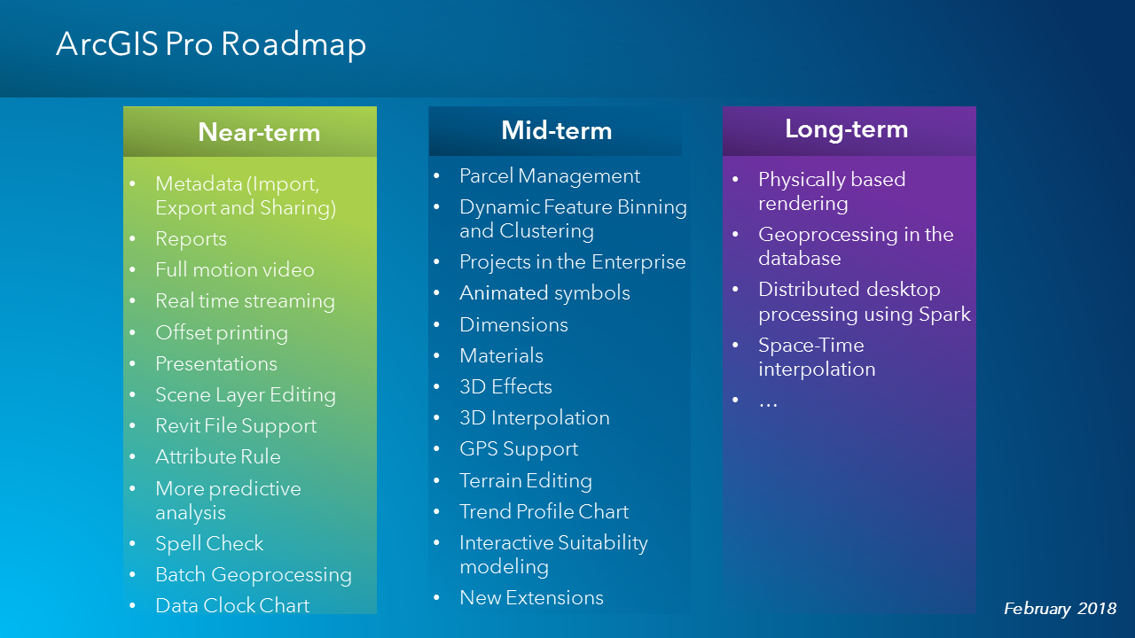
ArcGIS Pro is the premier desktop GIS for 2D and 3D mapping, analysis and editing. Come and hear from senior members of the ArcGIS Pro team as they discuss ArcGIS Pro’s latest capabilities and what’s planned for the future.
Technical Sessions and Demo Theater Presentations
Tuesday, March 6
ArcGIS Pro SDK for .NET: Getting Started
1:00 pm – 1:30 pm
Demo Theater 1
ArcGIS Pro SDK for .NET: Beginning Pro Customization and Extensibility
2:30 pm – 3:30 pm
Primrose A
ArcGIS Pro SDK for .NET: Custom States and Conditions
4:00 pm – 4:30 pm
Demo Theater 2
ArcGIS Pro: The Road Ahead
4:00 pm – 5:00 pm
Oasis 4
ArcGIS Pro SDK for .NET: Beginning Editing and Editing UI Patterns
5:30 pm – 6:30 pm
Mojave Learning Center
Wednesday, March 7
ArcGIS Pro SDK for .NET: Mapping and Layout
10:30 am – 11:30 am
Pasadena/Sierra/Ventura
ArcGIS Pro SDK for .NET: Advanced Pro Customization and Extensibility
1:00 pm – 2:00 pm
Santa Rosa
ArcGIS Pro SDK for .NET: Application Architecture Overview and API Patterns
2:30 pm – 3:30 pm
Mesquite G-H
ArcGIS Pro SDK for .NET: Advanced Editing and Edit Operations
4:00 pm – 5:00 pm
Santa Rosa
ArcGIS Pro SDK for .NET: New UI Controls for the SDK
5:30 pm – 6:00 pm
Demo Theater 2
Controlling the Chaos: Establishing Best Practices for Python Scripting
5:30 pm – 6:00 pm
Mesquite C
ArcGIS Pro SDK for .NET: Raster API and Manipulating Pixel Blocks
6:00 pm – 6:30 pm
Demo Theater 2
Thursday, March 8
Getting Started with the ArcGIS Pro SDK for .NET
9:00 am – 3:30 pm
Mojave Learning Center
Pipeline Spill Modeling with ArcGIS Pro, .NET, and Python
3:00 pm – 3:30 pm
Mesquite C
ArcGIS Pro: The Road Ahead
4:00 pm – 5:00 pm
Primrose B
Friday, March 9
ArcGIS Pro SDK for .NET: Beginning Pro Customization and Extensibility
10:00 am – 11:00 am
Primrose A
ArcGIS Pro SDK for .NET: Advanced Pro Customization and Extensibility
1:00 pm – 2:00 pm
Mesquite G-H
You can still register for the 2018 Esri Developer Summit. Come join us.


Article Discussion: