Early season’s greetings!! We’ve added several new enhancements to this holiday release of Web AppBuilder for ArcGIS. Many were highly requested by the user community.
2 New Widgets
Public Notification widget – This widget enables you to identify a collection of properties and create mailing labels (in PDF format) or a CSV file. This is a really useful tool for local and municipal government staff such as planning and zoning officials, to help them notify property owners and occupants of the selected properties.
For example, perhaps a fire department needs to send out a notice of hydrant flushing in a neighborhood. They could use this widget to select the properties in the proposed area, generate a mailing/contact list and inform the property owners in advance. A collection of properties to be notified can be generated by specifying a distance from a property boundary (buffer); selecting properties along an adjoining roadway; identifying properties within an administrative area; or drawing a specific area and identifying properties within the newly drawn area.
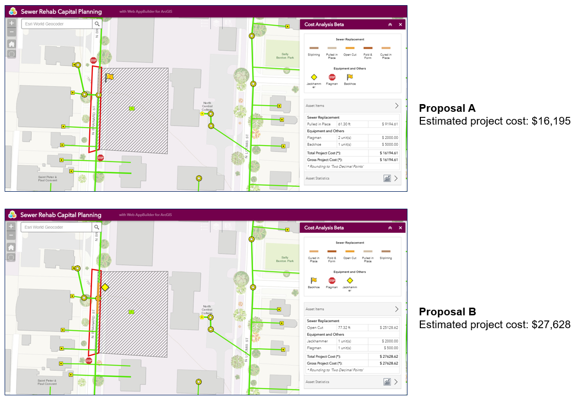
 Cost Analysis widget (beta) – This widget enables you to sketch a proposed design, then get an estimated cost of the project. When configuring the widget, you assign a cost factor for each feature you create. These costs are automatically tallied and provide an overall project or event cost. Additional cost factors can be applied, or the entire cost can be scaled based on factors not captured in the data.
For example, the app below displays the sewer system for the City of Naperville, IL. Using this widget, city planners and Water Department staff could add features that represent different infrastructure construction options to update the sewer network and get an estimation of the costs associated for both the materials and project. Different infrastructure plans can be easily proposed, along with their associated costs for easy comparisons. In this case, a modification is required along N Brainard Street (in the red zoning area) and two options are proposed.
 Widget Enhancements
- The Add Data widget supports uploading local KML files.
- The Bookmark widget enables you to save layer visibility settings.
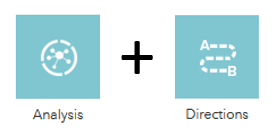
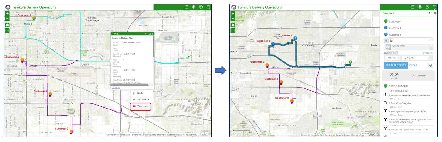
- The Directions widget has been enhanced to work more closely with the Analysis widget, specifically the Plan Routes tool.
In the Plans Routes tool, you provide a set of stops and the number of vehicles available to visit the stops. The tool assigns the stops to vehicles and returns routes showing how each vehicle can reach their assigned stops in the least amount of time. Learn more about this Analysis widget tool here. For example, the app below determines the optimal routes for delivering furniture orders to several customers from a warehouse. The company has 5 orders and 2 trucks available; the app leverages both the Analysis and Directions widgets. First, the Plans Routes tool in the Analysis widget is executed. Note: ensure the “include route layers” parameter is selected when you run the Plans Routes tool. Optimized routes for each truck is returned by the tool and the order in which they should visit each customer.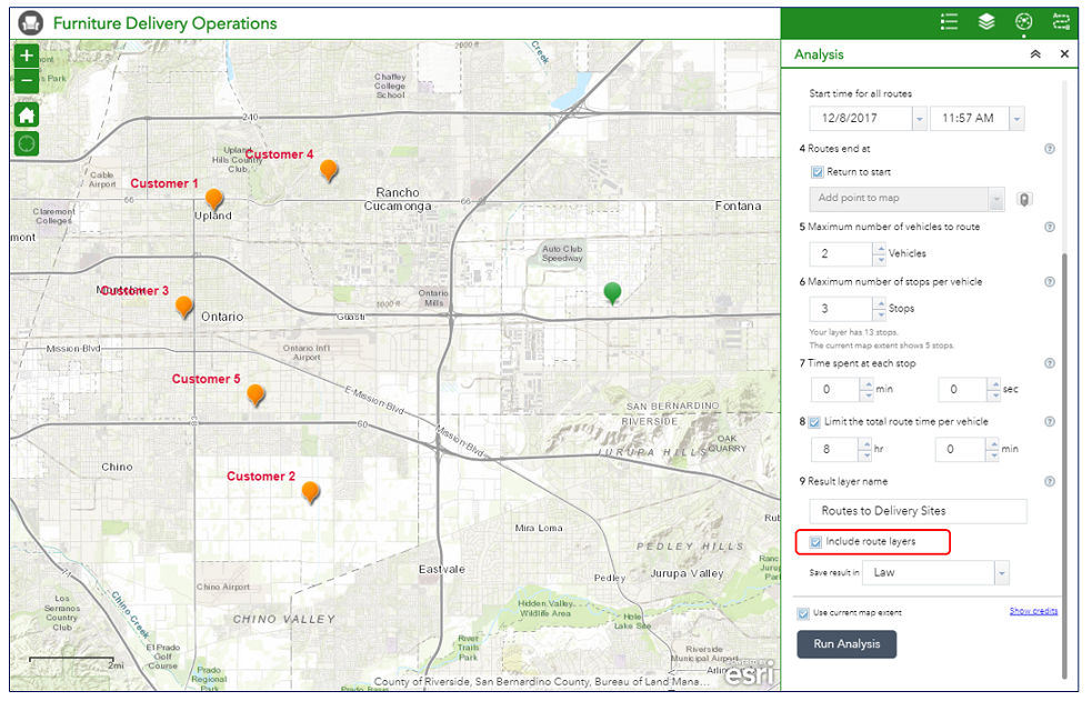
When an end user clicks on a route, in the pop up that displays they can select Open route to view the directions that were generated for the vehicle by the tool. This workflow will help mobile workforces reach more jobsites in less time, which increases productivity and can improve customer service.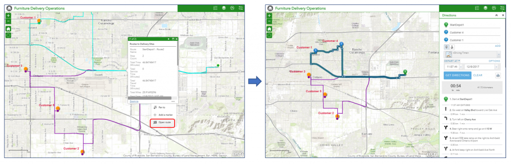
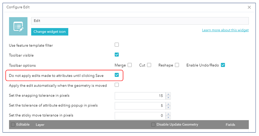
You can also modify the generated routes in the map display and the directions will be adjusted on-the-fly. This is pretty awesome!! - The Edit widget includes a new option to save all edits to attributes with one commit. This can help expedite editing workflows for feature attributes.

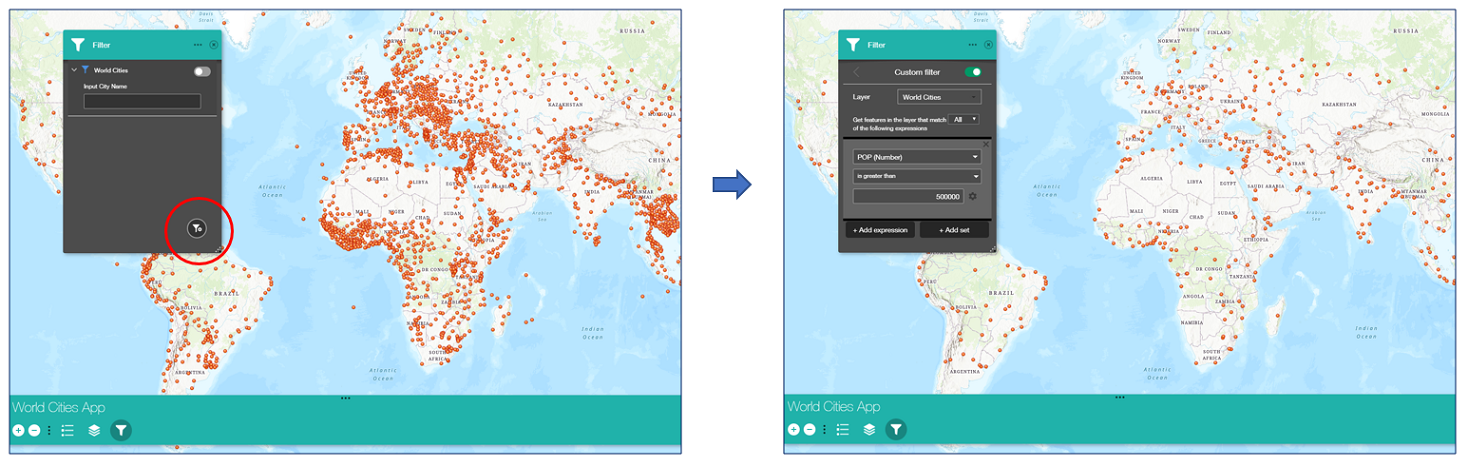
- The Filter widget now includes options to zoom to the features automatically when the filter is applied, to apply filters when the widget is opened, and an option to allow end users to create their own filter expressions. This enables them to quickly and easily define their own filters on the data in the app. Multiple expression sets are possible. For example, the app below has a Filter widget with a predefined expression to search for Country names. In the lower right corner of the widget dialog, the Create Custom Filter icon appears indicating that end users can build their own filters. When clicked, the widget dialog displays an interactive builder to create custom expressions, in this case searching for cities with populations greater than 500,000. This has been one of the most requested enhancements from the user community.

- Filter expressions also now support relative dates such as ‘today’ and in the ‘last week’. When Ask for value is checked, the default value can be blank.
- The Geoprocessing widget now supports the current map extent as an input and has the option to turn off the visibility of the output layer on the map by default.
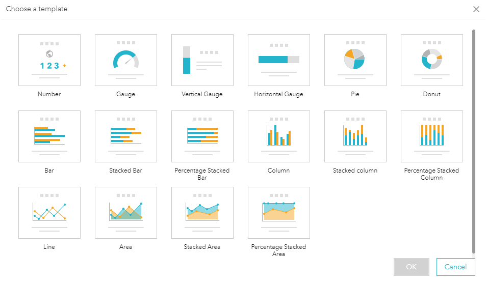
- The Infographic widget now includes 8 new templates: donut, stacked bar, percentage stacked bar, stacked column, percentage stacked column, area, stacked area, and percentage stacked area. It also supports custom colors per value field when applicable. This provides many more options for visualizing your data – especially when used with the Dashboard theme.
- The Info Summary is an in-panel widget for better display on devices and in the Dashboard theme.
- Output from the Print widget displays the local date and time format where the end user is located.
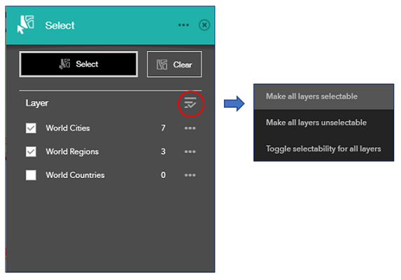
- The Select widget includes a new option to choose which layers are selectable and enables end users to toggle selectivity on/off.

- The Swipe widget now has options to specify which layers to swipe and to automatically zoom to the swipe layer.
- The Environment widget (for 3D apps) has been renamed to the Daylight widget.
Builder Environment
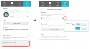
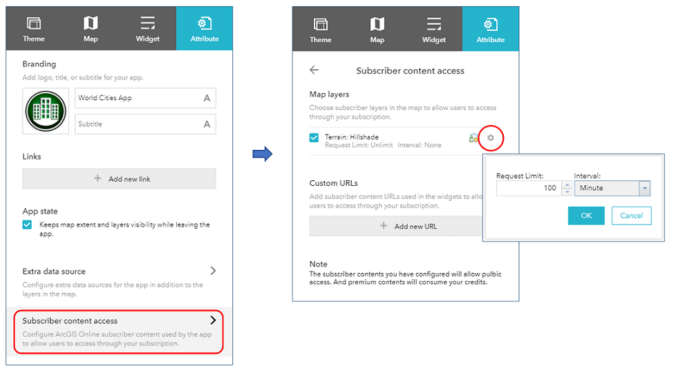
- When ArcGIS Online subscriber content is part of the app, the Attributes tab now includes more options for you to control the number of requests and interval for layers and services.
- Also under the Attributes tab, hyperlinks that are added can be any protocol supported by the web browser such as: HTTP, HTTPS, MAILTO, and FTP.
We hope you enjoy these new enhancements to Web AppBuilder and happy holidays!!
Sincerely,
The Web AppBuilder for ArcGIS Dev team


Article Discussion: