ArcGIS Field Maps is Esri’s new premier maps app on iOS and Android devices.
Field Maps will combine the following capabilities into a single app that is easy to use and simple to deploy:
- Simple map viewing and markup
- High accuracy field data collection and inspection
- Battery-optimized location tracking
- Work planning and task management
- Turn-by-turn navigation
Field Maps will include a new web app, integrated with ArcGIS, that can be used to configure and deploy maps optimized for your mobile workforce needs, create and assign tasks to mobile workers, and create and share views of worker locations.
The capabilities of ArcGIS Field Maps are not new and are currently implemented across separate field apps: Collector, Explorer, Navigator, Tracker, and Workforce. Working with multiple apps can pose several challenges to the mobile worker because it requires them to:
- Figure out which apps they need to use to satisfy their workflow requirements
- Download and sign in to each app individually
- Download multiple copies of map data to work offline
- Switch between multiple apps to complete workflows
Because of these reasons, we are bringing together the capabilities of these five apps into a single app.
ArcGIS Field Maps may be the only app your mobile workforce needs to complete their map-centric workflows. They will be able to collect data, mark up maps, capture location tracks, complete assignments, and navigate to assets all from one app.
This saves time for the mobile worker, because they will only have to download, sign in to, and work with one app – and it saves time for you, because you will only have to configure maps for one application.
ArcGIS Field Maps saves space on your mobile devices by eliminating the need to duplicate data, such as base maps, across multiple apps. It also creates a tighter synchronization between the office and the field by only requiring one web app/mobile app pair.
We’ll be releasing ArcGIS Field Maps in three phases.
Phase I – Esri’s premier maps app for mobile devices
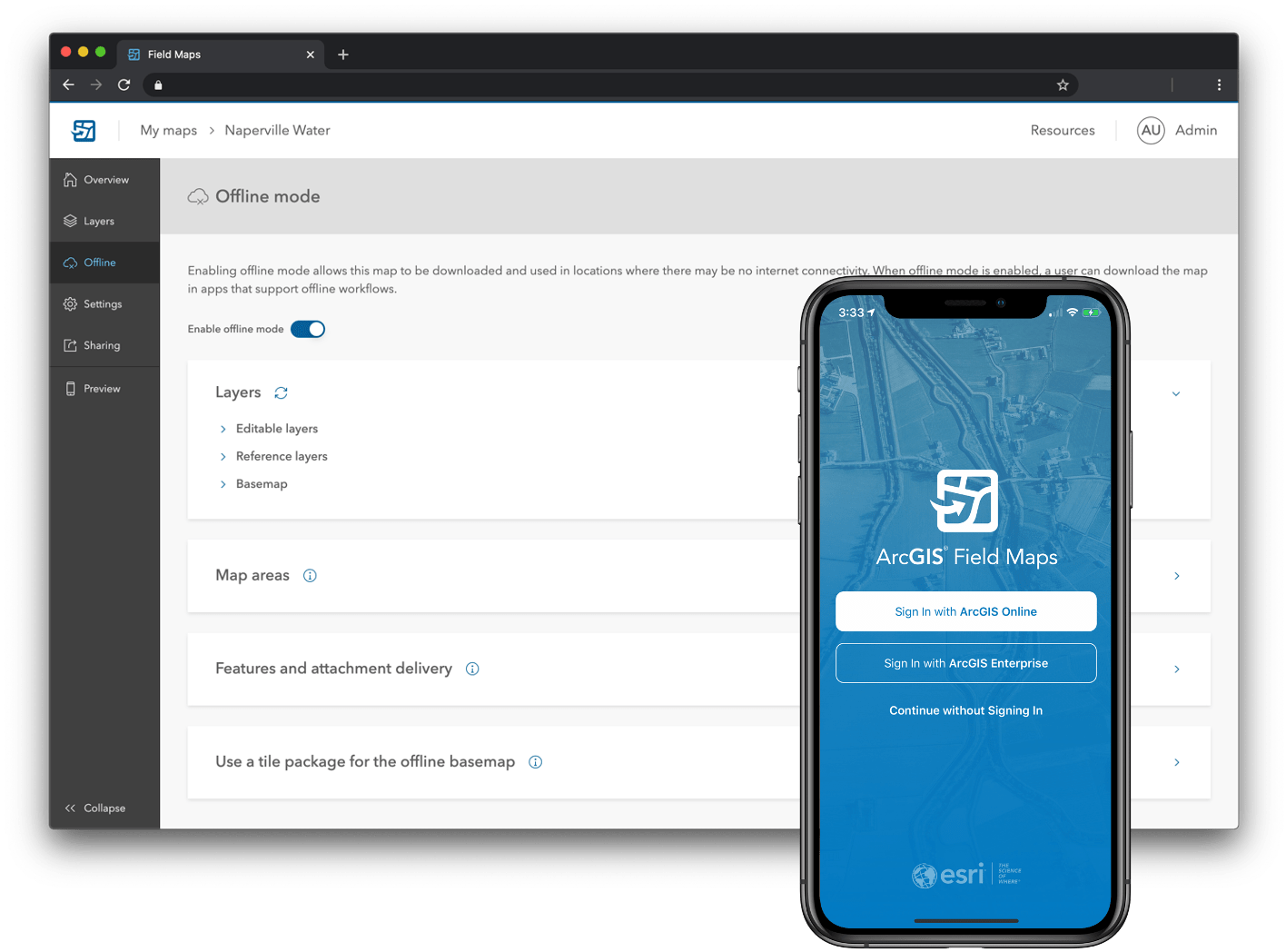
In the first phase, you’ll be able to use the Field Maps mobile app to explore the maps you make in ArcGIS, collect and update your authoritative data, and track where you’ve gone, all within a single location-aware app.
We’ll introduce the new Field Maps web app so that you can streamline the map configuration process in ArcGIS Online and ArcGIS Enterprise for your field deployments. This includes a single location to configure the maps you own:
- Manage the offline mapping and data synchronization capabilities of your maps
- Configure the properties of individual map layers
- Create and modify feature templates along with their default values
- Author new smart forms for advanced form editing capabilities
- Preview and share maps before deploying them to your mobile workforce
Starting with all of the current data collection capabilities found in Collector, ArcGIS Field Maps will include the map viewing and markup capabilities of Explorer, and the location tracking capabilities found in Tracker.
Coming into the ArcGIS platform, starting with this release, is the ability to create powerful new smart forms using the Field Maps web app. Mobile workers can then use these forms in the mobile app to collect data and perform inspections in the field. These new smart forms will be stored within the maps you author so that as we build more editing capabilities across the platform, smart forms will appear in web and desktop apps as well.

The first set of smart form capabilities will include:
- Groups – a new form concept where you can sort and organize fields into a group that has a name and description. Groups collapse and expand, disclosing only the information you need to see.
- Conditional visibility – apply logical expressions to fields so that you only see the information that needs to be filled out.
- Required fields – specify whether or not the mobile worker must add a value to a field before submitting edits.
Using the Field Maps web app, you’ll have an intuitive drag and drop experience for designing smart forms – one that includes the ability to preview the form before you deploy the map.
The beta program will be open to all Esri customers that have an ArcGIS Online subscription or ArcGIS Enterprise 10.6.1 or higher.
Phase II – Workforce coordination
Following the initial release of ArcGIS Field Maps, we will introduce workforce coordination capabilities in Field Maps. The ArcGIS Field Maps mobile app will include a “To Do list” within the maps you use. If you are using integrations with partner applications, like Cityworks, to support work management activities with Collector today, please read the Q & A section below discussing partner apps and know that the app link scheme will be fully supported beginning with Phase I. Partners will be able to take advantage of new app link parameters as well as utilize the ArcGIS API for Python apps module. We do not have a release date set at this time.
Phase III – Turn-by-turn navigation
Starting with Phase I, you’ll be able to launch consumer navigation apps like Apple Maps and Google Maps from the ArcGIS Field Maps app. Moving forward we will evaluate the advanced enterprise navigation capabilities of ArcGIS Navigator and consider it’s inclusion as a new capability of Field Maps. We do not have a release date set for Phase III at this time.
We expect that you’ll have lots of questions about ArcGIS Field Maps and we’ll be writing many additional blog articles as we launch the beta program and start releasing new capabilities. However, here are a few things you should know right now:
Q. Does this new app take away any functionality that was previously available?
A. No! We are planning for feature parity between Field Maps and the apps that it is replacing along with many exciting new features.
Q. How does this new app impact the product road maps for the individual apps?
A. With Field Maps as the primary focus, all road maps lead to one product offering. You’ll see many new features coming in ArcGIS Field Maps and with our centralized focus, our goal is to accelerate the pace of development.
Q. How does this affect licensing and pricing?
A. The short answer is that it does not. ArcGIS Field Maps does not have any additional license fee and will honor all current user types and their privileges. If you sign in with a Viewer user type, you’ll see a list of maps you can open but not edit. If you sign in with a Field Worker user type, you’ll be able to edit maps that support updates. If you sign in with a Viewer user type and the member has been assigned a Tracker premium add-on license then they can track.
Q. How does this affect ArcGIS Survey123, ArcGIS QuickCapture, ArcGIS Mission, ArcGIS Indoors and ArcGIS Earth?
A. All of the apps mentioned above will remain focused apps and will not be incorporated into Field Maps. Field Maps will support app linking, like the other field apps, so multi-app workflows that compliment the capabilities of ArcGIS Field Maps will be fully supported and examples of how to use app linking will be available.
Q. Will integration with partner and 3rd party apps be supported with ArcGIS Field Maps?
A. Yes! We are fully supporting integration using the Universal App Link scheme that we introduced into our apps. Please read the Collector App Link doc and/or the Explorer App Link doc to better understand how app linking works and if you are using a linked partner solution today, please reach out to your partner as well. In addition to app linking, we will bring forward app integration into the Apps Module with ArcGIS API for Python.
Q. What happens to existing field apps?
A. We recognize many customers have significant investment in our current apps and have created institutional knowledge supporting them – including training, help documentation, cheat sheets, and more. We are continuing support of Collector, Explorer, Tracker, Workforce and Navigator and will update these apps with strategic bug fixes when needed. However, all future enhancements for each app will be included in ArcGIS Field Maps only. We do not intend to introduce new functionality into the existing applications. We will announce retirement of existing apps in the future, however no official date has been set at this time. Retirement plans will be announced at least 6 months in advance so that you have time to migrate.
These are exciting times for Field Operations apps. We’ll share out a link that you can use to join the Early Adopter program with our launch early in July. If you have any questions ahead of our beta launch announcement, please send inquiries to ArcGISFieldMapsBeta@esri.com.

Really good news, I never did understand the direction ESRI were taking with all the separate apps, whoever is responsible for bringing the development teams together to focus on a single app has a big thank you from myself and the GIS team at Eurovia.
I would buy you a pint if all the pubs weren’t closed and I wasn’t locked in doors 🙂
Very exciting news! That will make field-working so much easier
Slow clap… I guess this is why I was getting push back from the Explorer team for incorporating high accuracy. Finally our crews can do high-accuracy locates on our valves with our RTK GNSS!!
Jeff and Team, I like the technology direction ArcGIS Field Mapping is heading and the value it brings.
This app will available for personal use license?
I know this isn’t replacing Survey123 but I’ll be interested to join the Beta and try this out. It could actually suit our needs better with the all-in-one approach.
Thanks Jonathan! We look forward to your feedback!
Personally i would rather see the current apps improved and the growing backlog of bugs fixed. Another app that does the same thing but does not advance anything makes no sense to me. Especially since these new premium apps are more money on top of existing ELAs. Makes it feel more like a revenue play. We already invested years in the current apps – do not want to start over again.
What we really need is a way to subset or filter points offline. This has been an issue with Collector since 2015. Just an example.
Thanks for considering.
Thank you for your feedback Doug. To clarify a few things:
– There is no additional cost for Field Maps. It is bringing together the capabilities of other field apps into a unified experience and retaining the licensing you currently have. I have updated the answer in the Q & A to hopefully better express this.
– the code base we are working from is Collector so you will receive all of the capabilities that Collector has today and gain much more as well.
– with filtering when offline, we do have feature search capabilities in Collector today that work both online and offline. When you search within the app it will provide a filtered list of features that you can tap on and edit. You need to set the feature search parameters (what fields to search against for a layer) in the item details of a web map. Here is a link to the documentation on how to do this within the ArcGIS Online help: https://doc.arcgis.com/en/arcgis-online/create-maps/configure-feature-search.htm. We’ve also added this to the “Make a map” topic in the Collector help system here: https://doc.arcgis.com/en/collector/ipad/help/make-map.htm. If this doesn’t fit your needs, please let us know by submitting an idea to ArcGIS Ideas or commenting on the Collector GeoNet forum too! We watch and pull requirements from that site quite often.
Thanks again for your feedback.
So does Conditional Visibility also mean contingent value domains? The lack of that functionality has kept our school district from adopting Collector. We have nearly 100 sites with multiple buildings and nearly 15000 rooms. We need to be able to filter those values in the field and we can’t do that with Collector.
I would like to join as a beta tester starting in July. Interesting way to bring all the field apps together.
Thats great to hear Nita! Please email us directly at ArcGISFieldMapsBeta@Esri Inc..com and we will put you on the mailing list. We’ll also be updating this post with a direct link to the beta program once we are live too. Thanks!
Will the new app allow bread crumb tracking like the old collector did? We need high resolution (sec to sub sec collection) tracking capabilities!
Hi Preston,
Our current plans with Field Maps is to bring the Tracker capabilities into the app. It uses a distance-based/motion-based logging approach where the granularity of tracks is based upon your activity mode. If walking the resolution is every 5m, if driving then every 30m, for any other form of activity it is every 10m. If you need finer grained breadcrumbs than this, I’d really like to hear more about it. We have a lot that we want to do with location tracking in future releases so love to get your feedback!! Please feel free to contact our team directly at ArcGISFieldMapsBeta@Esri Inc..com.
Thank you,
Jeff
Jeff,
The only real question to ask here Jeff is if ArcGIS Field Maps will help the Maple Leafs win the Stanley Cup this year??
Go Leafs!
This is exciting and we like the possibilities this opens up. We do have one question. We had worked with the explorer team on getting the .NET version working because we have some field users using PCs that require offline scenarios. Explorer was going to be our replacement of packaged ArcReader maps. Will we still have a .NET (Windows) version of this new app for that use case?
Hi Doug,
Great question! We will continue to support and make minor updates to Explorer on the Windows platform for the foreseeable future. However we have not actively started development of Field Maps on the Windows platform. Our plan is to release phase 1 on the iOS and Android platforms and then re-evaluate where we go next on the Windows platform in September. We will make sure to let you know where we are heading on Windows as we move forward.
Thanks!
That sounds like good news. Sounds like we can keep moving this direction and if Explorer for windows does go away, it won’t be until there’s another option. Thanks for the info. Helps us in our planning.
Will the ability to side-load a mobile map packages that is currently present in Explorer be included in Field Maps? This is incredibly useful in austere environments when maps need to be updated and disseminated.
Hi Michael,
Yes the ability to side-load and to download mobile map packages will be included and you’ll be able to test them in the first beta release too if you would like. We’d love to get your feedback on it.
Thanks
Jeff
Where do you sign up for the Beta?
Hi Larry. We’ll be updating the post to include the early adopter link when we launch the beta program. If you’d like, please shoot us an email at ArcGISFieldMapsBeta@Esri Inc..com and we’ll add you to our mailing list as well. Thanks!
Hi Jeff,
Really good news to see a lot the apps combined together into one service. Is there any plan to implement Survey123 in the app overtime? I find keep finding that I would like to have features from both Survey123 and Collector. It would be really good to harness both Collector and Survey123 features in one app. For example it would be good to see existing features when collecting data with Survey123 without going in the inbox or be able to do Survey123 field calculations and have a Survey123 style form when using Collector.
Cheers,
Will
Looks interesting!
Mr. Jeff, Would you please advise how can I participate in one of your ESRI conferences?
https://www.esri.com/en-us/about/events/uc/registration
Looking forward to giving the beta a test run… Already a member of ESRI early adopter program, is Field Maps a separate invitation or will it be part of the normal notice process?
Good News! Will the app offer the possibility to make own customizations (like in Survey123)?
Katharina – you will be able to configure the application capabilities, as you can with Collector today. Also you will have a designer for form construction as Survey123 does. However we will not be providing the source code for the app.
For how long the original Collector app will be supported after its removal from the app store?
We haven’t set a date yet for official support. It will most likely stay in support through 2021. We will announce deprecation plans as soon as we can.
I love the concept of pulling Esri’s best mobile apps into one application!
Is there anyway I could get access to the web app? Testing the mobile application is fine, but since moving into phase 1 I can’t access the smart form capabilities without access to the web application..
Apologies for the late reply Lance, but the web app will remain in beta until the December release of ArcGIS Online. With the September update it went live for all organizations. Please let us know if you still do not see it.
Will you plan to support snap feature in Android?
Yes. It is included in this release.
Interesting!
But what’s the minimum required Android OS for this new Field?
It’s Android 8 Benny. Will be available in Google Play tomorrow.
ArcGIS Field Apps looks great. Thank you for putting the field applications together. It will make future mobile applications much easier to support and develop. We already have a number of applications that link from Collector to Survey 123.
I was successful logging into ArcGIS Online from ArcGIS Field app, and saw all my web maps, took offline and edited some features.
Does ArcGIS Field App work with Enterprise Portal yet? I could not log onto our Portals from ArcGIS Field App today. Is there something in the Enterprise that needs to be done to allow log in? It there a particular version of enterprise that is required. We are running 10.7.1. What could be wrong with our setup?
Will there be capability to create a hyperlink that launches Field Maps and opens a specific map on mobile devices? We currently build hyperlinks outside the ESRI environment to launch WMA’s on iPads etc. through the use of tags in the URLs.