The latest ArcGIS Earth releases offer exciting new features and enhancements that make it easier and faster to work with your 3D geospatial content. Some of the key highlights include cross-platform support for 3D Tiles, app linking, KML workflow enhancements, and improved 3D performance when working with scene layers.
Cross-Platform Highlights
3D Tiles
3D Tiles support was introduced in ArcGIS Maps SDK’s for Native Apps 200.4 earlier this month. This introduction laid the foundation for ArcGIS Earth to enable 3D Tiles visualization on desktop and mobile. 3D Tiles, like Indexed Scene Layer (i3s), is an Open Geospatial Consortium (OGC) standard designed for streaming and rendering large volumes of 3D geospatial content. We are committed to open standards and interoperability, and we aim to support a wide array of industry standard sources and formats. Whether you are online or offline, ArcGIS Earth enables multiple ways to visualize and explore your 3D content. Visualize 3D Tiles as continuous meshes or discrete 3D objects from a local directory or 3D Tiles hosted service on ArcGIS Online or 3rd party server.

Here’s a summary of 3D Tiles support in ArcGIS Earth:
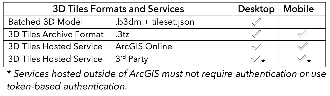
Just like scene layers, 3D Tiles layers can be used with interactive analysis tools like line of sight, viewshed, and 3D measurements.
App Link
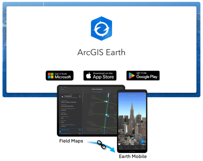
ArcGIS Earth provides mobile workers with secure access to your organization’s 3D assets on their mobile devices, ensuring they have the most current information. Workers can easily locate assets and data, and even add drawings and notes to document and share findings with others, even when disconnected.
We made it easier to integrate 3D content into your mobile workflow by adding support for app links for Windows, Android, and iOS. ArcGIS Earth can be launched from a hyperlink or integrated with other apps with the following link: https://earth.arcgis.app. Each app link begins with this base URL and can be further customized using URL parameters.
3D Performance Improvements
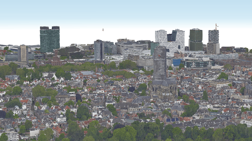
We focused a lot on enhancing 3D performance for local and hosted scene layers this release cycle. You will experience a significant increase in rendering speed and hardware resource efficiency when working with these layers.

These improvements are significant, but our work continues. There are a few outlier examples of scene layers containing “no data” nodes which may cause rendering inconsistencies. The handling of datasets with no data nodes will be resolved in the fall release. We are committed to improving performance across a wide array of data types in the coming releases. Stay tuned for future updates.
ArcGIS Earth for Desktop
Realistic Star Background
National Aeronautics and Space Administration (NASA) realistic stars background now replaces the generic space background. Make your 3D scenes pop with this new visual effect.

WGS 1984 Basemap Auto-Sourcing
A new feature has been added to auto-source ArcGIS Online basemaps to match your preferred spatial reference. When you change the default spatial reference from Web Mercator to World Geodetic System 1984 (WGS 84), the application will automatically source the associated WGS84 basemaps from ArcGIS Online in the basemap gallery. This change improves overall performance for those who use WGS 84 as their default spatial reference.
Bookmarks
This update added two new bookmark enhancements to simplify video creation. With the new bookmark enhancements, you can easily turn your bookmarks into videos or ArcGIS Earth movie projects. Export high-quality videos of your bookmarks or convert them to movie projects for further editing and animation.
Export bookmarks to video
In just a few clicks, you can now export your bookmark groups to MP4. Bookmarks are a snapshot of your scene that capture not only camera perspective and extent, but also active layers and environmental effects. You can fine-tune transition parameters for each individual bookmark, such as the duration and smoothness of transitions between bookmarks. This approach allows you to create videos that present your data in the most effective way possible. Simply select Export to Video in the bookmark Export panel, choose between Efficiency or Quality export modes, and click Export Video. The ArcGIS Earth movie enhancements section provides more details on these new video processing modes.

Convert bookmarks to ArcGIS Earth movie projects
Exporting bookmark groups directly to video helps create informative and engaging content quickly, but what if you need more control over your video production? For example, you may want to add additional elements like animations, captions, screen overlays, or voiceovers to better convey your story. To add versatility to the bookmark workflow and provide more customization options, we have added a new feature that lets you import a bookmark group into an ArcGIS Earth movie project. Think of bookmarks as storyboards that help you plan your next video project. To convert your bookmarks to a move project, simply click the convert to movie button.

ArcGIS Earth Movie Enhancements
Toolbar updates
Producing professional quality movies can be a tedious task without the proper tools. Suppose you are making a documentary about climate change using a collection of animations, interviews, narration, and geospatial layers from the ArcGIS Living Atlas. The ability to effectively edit and arrange these elements are crucial for creating a seamless and impactful story. To improve workflow efficiency, we introduced a new set of tools for managing blocks and tracks. The following new tools have been added to ArcGIS Earth Movie’s toolbar:
- Rectangle Select – Click and draw a rectangle to select multiple blocks at one time.
- Align – Align blocks to one side’s edge when multiple blocks are selected.
- Merge – Merge two or more blocks of the same type into a single block.
- Split – Divide a block into two individual blocks.

With these tools, you can unleash your creativity and produce stunning movies with ArcGIS Earth.
New export modes
Three new export modes have been added to give you more control over processing time and output quality. These modes include:
- Efficiency Mode prioritizes fast export time and smaller file size, ideal for quick sharing. May reduce video quality.
- Balanced Mode provides a compromise between speed and quality.
- Quality Mode prioritizes output quality over export time, ideal for professional presentations. Export time and file size will be larger.

New dynamic markers
You can now use three new types of markers to make your movies more dynamic. The new marker types supported include GIF, Video, and Billboard.

In-app voice over
In app voice over is now supported. Simply click the record icon in the audio track to begin narrating your video in real time.

KML Enhancements
Here are a few of the KML enhancements introduced in this release:
- Keyboard shortcuts have been added to help you quickly navigate stacked pop-up windows. The following keyboard shortcuts are supported: Page Up and Page Down & Tab and Shift + Tab
- Placemarks can now be created by right-clicking on the globe.
- Support for <NetworkLinkControl><message> syntax has been added. This enhancement enables you to deliver pop-up messages when a KML network link is loaded. Data licensing and use guidelines are a couple examples of how this enhancement can be implemented.
- Improved handling of referenced files (icons, image overlays, attachments, etc.) when saving as .kml and .kmz.
- Time enabled screen overlays are now supported.
For a full list of KML enhancements please visit the Release documentation.
ArcGIS Earth for Mobile
OGC GeoPackage
ArcGIS Earth Mobile adds support for a new package type, GeoPackage. GeoPackage is an OGC spatial data storage format that can contain multiple datasets of geographic features, non-spatial tabular data, and raster data. GeoPackages can be added from a local file directory or hosted portal item. GeoPackages hosted as portal items are searchable and will be downloaded to your local device. Our initial support for GeoPackage uses a generic symbology renderer for feature layers. This will be enhanced in a future release, giving you more control over how the data is represented.
Please note: GeoPackages containing datasets with large amounts of features can cause performance issues. We recommend using GeoPackages with fewer than 50,000 features per layer for optimal performance.
Add Pictures to Layers
ArcGIS Earth for Mobile provides a simple workflow for capturing data on the go. In our last release we introduced the ability to draw lines and polygons. We have further enhanced that workflow by adding the ability to attach photos to placemarks, lines, and polygons. Whether you’re a professional or an outdoor enthusiast, ArcGIS Earth for mobile makes it easy to add spatially enabled field notes, insights, or memories.

Web Scene Slides
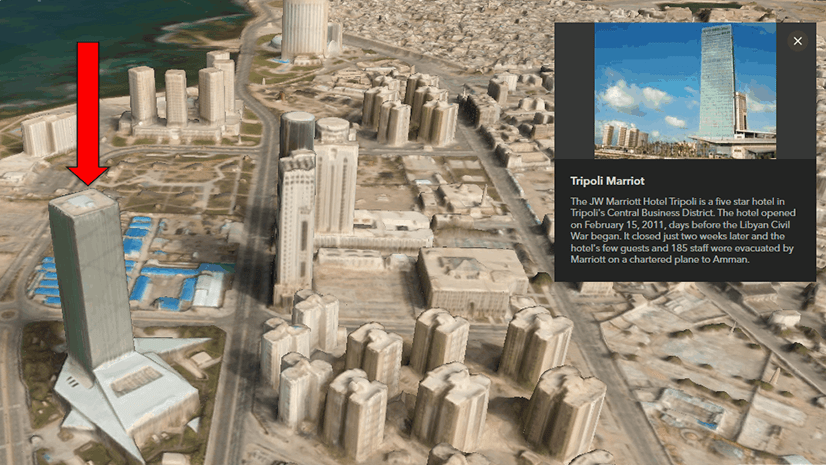
Web scene slides are now supported in ArcGIS Earth for mobile. With web scene slides, you can easily access and navigate different views of your 3D data in the field. This can help you visualize key geospatial elements of a construction project, such as the terrain, 3D scans, subsurface utilities, building designs, and more from different angles and perspectives.

Closing Comments
We hope you enjoy all the new features and enhancements brought to ArcGIS Earth for desktop and mobile this release cycle. Please continue to send us your feedback, as it is essential for our collective development and progress. The entire product team is grateful for your ongoing support for ArcGIS Earth.


Commenting is not enabled for this article.