Buckle up, this is a big update! We are happy to introduce the winter releases of ArcGIS Earth for desktop and mobile. There is a lot to go over, so let’s get started.
ArcGIS Earth for Desktop
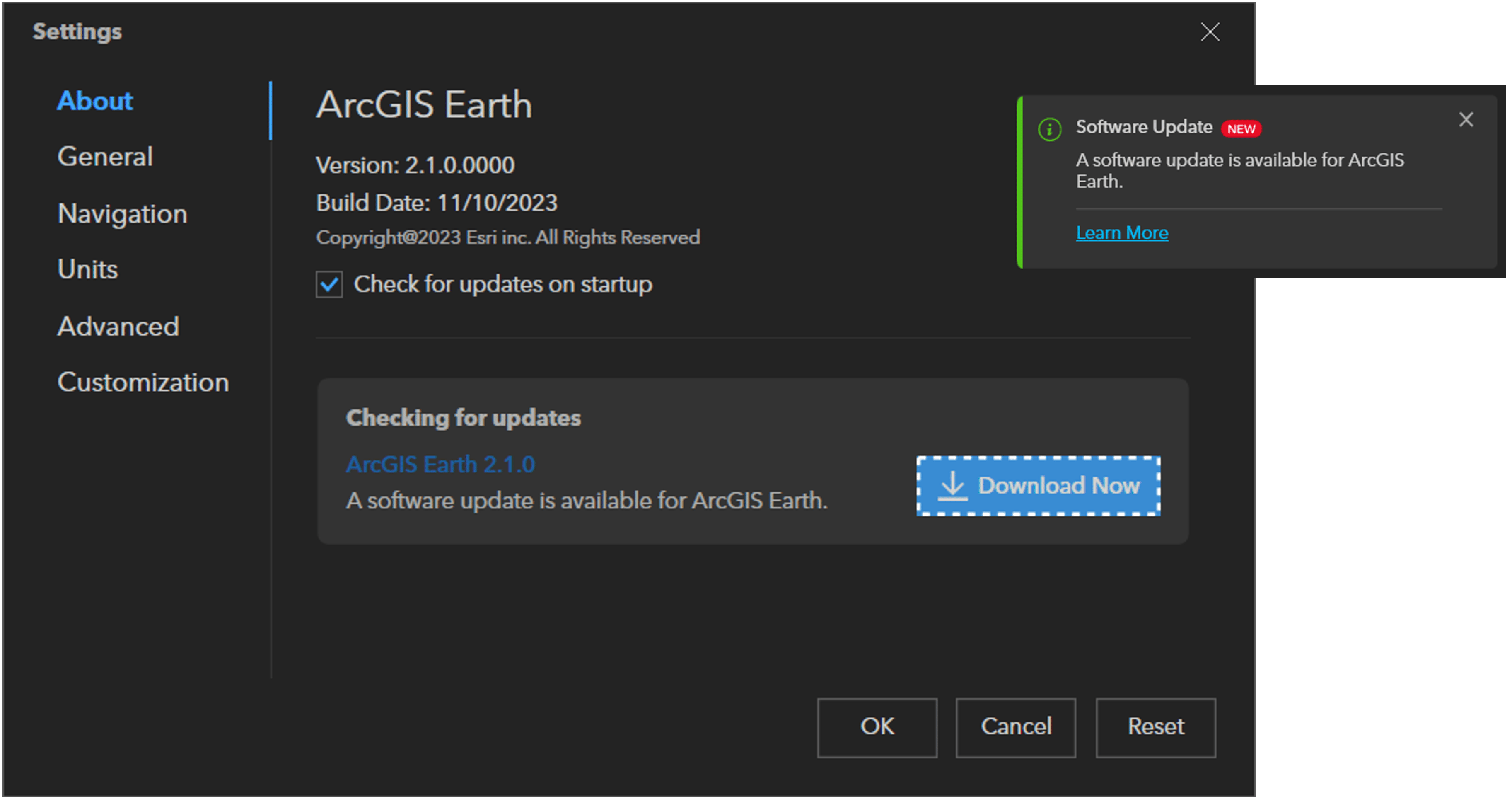
ArcGIS Earth Updater
ArcGIS Earth now has a new feature that helps you keep up with the times. It’s called auto update, and it will let you know and help you install the latest version when it comes out. This way, you won’t miss out on the latest features, enhancements, bug fixes, and security patches.
Label KML Lines and Polygons
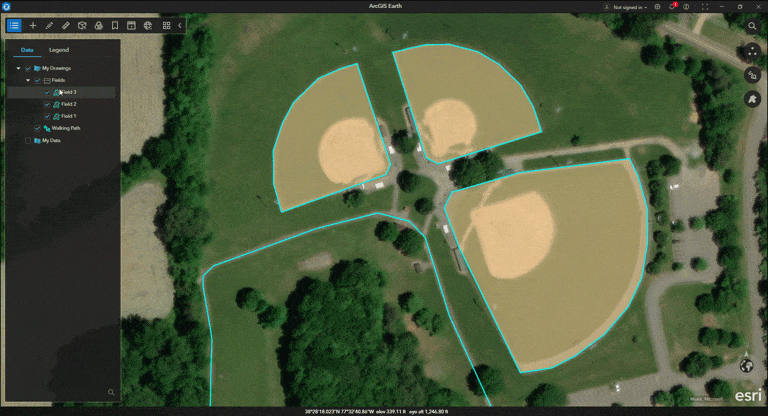
KML users know the struggle of labeling lines and polygons. One of the biggest limitations of KML was the inability to label lines and polygons directly. It was a hassle to use placemarks or multi-geometries for that purpose. This little quirk in KML sparked quite the buzz in online forums and GIS circles over the years. We heard your collective voice and are happy to announce that ArcGIS Earth now supports the direct labeling of KML lines and polygons. You no longer need to manage labels separately! Simply use the Label toggle switch to turn labels on/off within in the layer properties window.
KML Enhancements
Our improvements to the KML workflow this release go beyond labeling KML lines and polygons. ArcGIS Earth is a global tool that serves many different organizations and sectors. We listen to our users and try to make our KML support better, especially for workflows and processes that depend on the format. KML’s flexible and open design has made the format adaptable for various uses, from simple map notes to complex custom solutions. Some of the most requested KML enhancements were addressed this release cycle. Let’s explore some highlights on what’s new with KML in version 2.1 below.
Level of Detail
There are some seriously large KML datasets out there! To optimize these data for rendering, it is commonplace to use a technique known as level of detail. Level of detail varies the amount of data displayed based on a viewer’s distance from the objects. This technique helps you to optimize both the appearance and the speed of visualization when dealing with big and complicated datasets. We introduced KML level of detail in ArcGIS Earth as a necessary enhancement and believe it will significantly improve your experience working with multidimensional data.
Icons
We gave some much-needed love to KML placemark icons this release. Based on your feedback, two new features were added: allowing transparency for all placemark icons and supporting more offline placemark icons. Before, only default KML icons could have transparency settings. We fixed this problem, and now all icons can have transparency. Also, only built-in icon sets (paddle, pushpin, and shapes) worked when offline mode was enabled. To provide additional customization options, ArcGIS Earth now supports additional icon icon libraries offline. Additional libraries will not be pre-installed, you will need to download the individual icons and place them in the appropriate folder. Additional details can be found in resources.
Layer Highlight Effect
Sometimes it was hard to tell which KML layer you picked in a scene. That’s because they were all drawn in cyan, and that was also the color for showing what you selected. We made selected layers glow to make it easier for you.

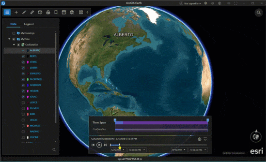
Time Enabled Data
We made the display and the use of KML data with time information better in ArcGIS Earth. If you pack a bunch of time enabled layers in one KML dataset the data may span days, months, years, or even decades. As a result, the time slider in ArcGIS Earth now dynamically adjusts based on which layers are active. Plus, we also made the animation of the data smoother. You only see the KML elements that match the time range you want to play.
Additional Enhancements
If you are interested in exploring the full list of KML enhancements for this release, please visit resources.
Navigation and Location Enhancements
Disable Default Fly-To Angle
We added an option to settings to disable the default fly to angle. When you set the setting to none, flying to layers will maintain an overhead perspective.
Additional Support for Location Units
Support for Degree Decimal Minutes coordinates was added. In addition, we have added support for negative latitude and longitude coordinates.
Reorder and Rename Geopackage and Mobile Geodatabase Contents
Have you ever wanted to change the order or rename the contents within a geopackage or mobile geodatabase? We added support for ordering and renaming the contents of a geopackage and mobile geodatabase. This enhancement will improve the usability of these package formats in ArcGIS Earth.
Scene Layer Offset
A bug that made 3D object scene layers stay in drape mode prevented the use of an elevation offset. Also, 3D point scene layers did not support elevation offset. Both problems have been resolved. 3D object scene layers will now load in absolute mode by default, allowing the setting of an elevation offset. These fixes will greatly enhance the usability and rendering of 3D object and 3D point scene layers in ArcGIS Earth.
Layout
Quality of life improvements were made to the export layout feature. When adding marginalia elements, you can use undo/redo and copy/paste hot keys. In addition, we improved the behavior of text boxes and legend elements.
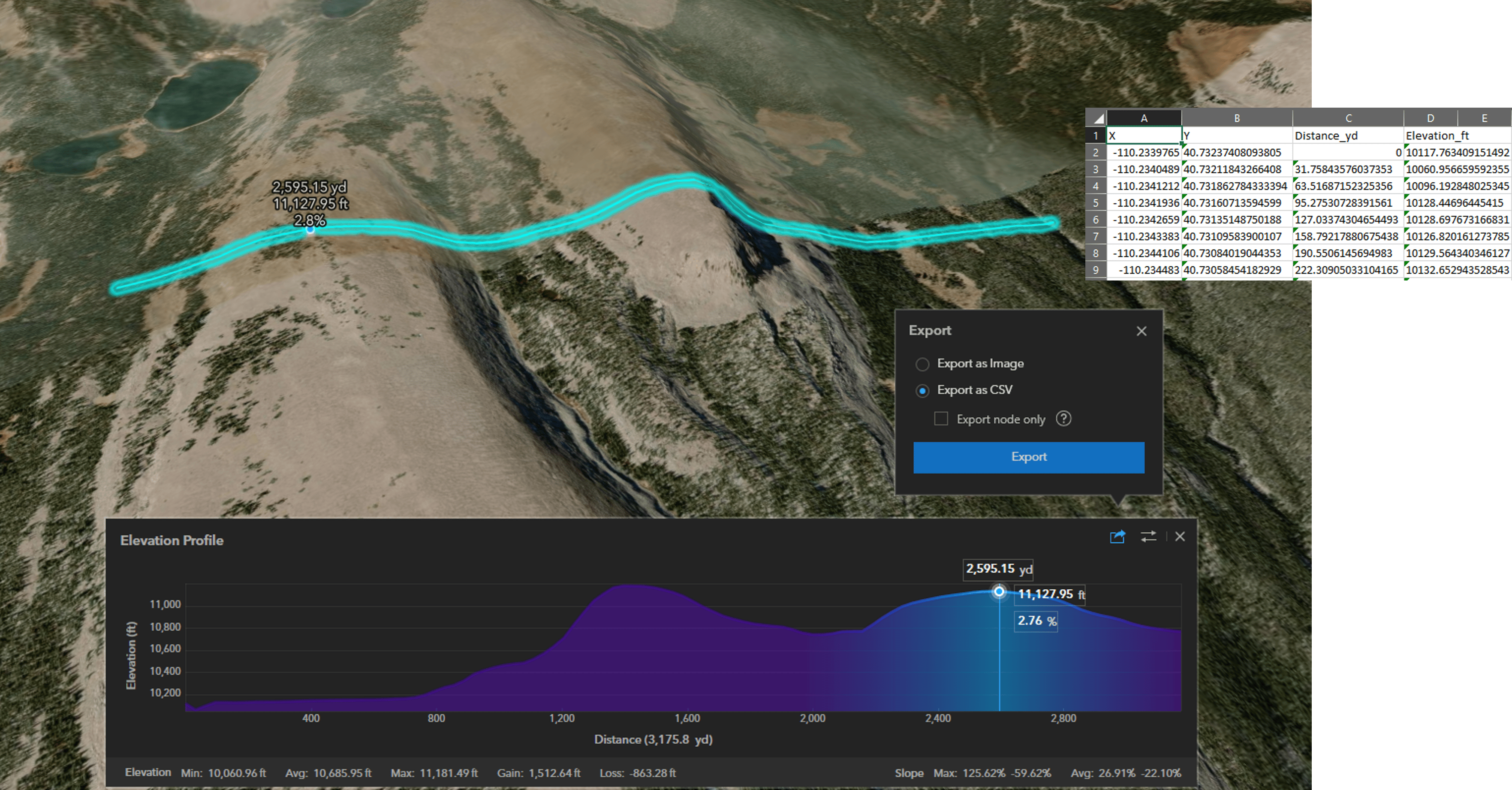
Export Elevation Profiles as CSV
You can now export elevation profiles as .csv files, with export options that include the default interval or custom nodes drawn on the globe for detailed line analysis.
ArcGIS Earth for Mobile
ArcGIS Earth reached a major milestone with the 2.0 release. For nearly a year, we worked hard to rebuild the app from the ground up. The rebuild began with a codebase migration to the new ArcGIS Maps SDKs for Kotlin and Swift. Moving to a new codebase is always challenging, but the ArcGIS Earth team has some of the most skilled mobile developers in the world. They deserve praise for their hard work and devotion in providing a user experience of the highest quality. Let’s explore the result, by highlighting what you can expect with ArcGIS Earth Mobile 2.0.
User Interface Redesign
Toolbox
We came up with a new round wheel toolbox design that’s perfect for mobile interaction. The toolbox lets you easily and naturally use the different features of ArcGIS Earth Mobile, such as adding data, drawing, measuring, 3D analysis, underground mode, AR mode, capturing GPS tracks, and creating tours.
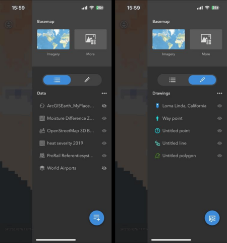
Table of Contents
To make your user experience more intuitive, we gave the table of contents a makeover. You can now access a basemap gallery, a data list, and a drawing list in a fresh new layout. With the new layout design, we wanted to simplify how you manage the data elements of your scene by bringing them together. You can now access data from your device or online service, change basemaps easily, add drawings, and control visibility from one place.
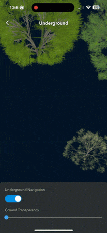
Underground Visualization
We added a new underground mode. This mode will let you to change ground transparency and navigate underground. Changing ground transparency will let you see features rendered below the surface in 3D. Turning on underground navigation will get rid of the surface constraint, making it easier for you to explore subsurface data. And if you want to know where you are, just use your GPS location and compare it with what’s under your feet.
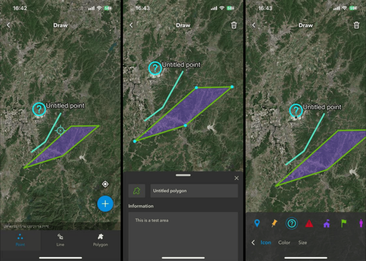
Draw Lines and Polygons
The long-awaited feature is here… we added support for drawing lines and polygons! You can now create and edit all three geometry types, change styling properties, and share them as native .kml/.kmz files. This new feature, combined with the ability to view 3D data, will open new collaboration and communication pathways in the field. Enhance your outreach and make a bigger difference with ArcGIS Earth Mobile, since it is free and open to everyone. With ArcGIS Earth Mobile, you can draw features to represent information with spatial context using representations such as roads, boundaries, areas, and points of interest. Communicate your field gathered insights to important stakeholders or import them into ArcGIS Earth Desktop for additional refinement.
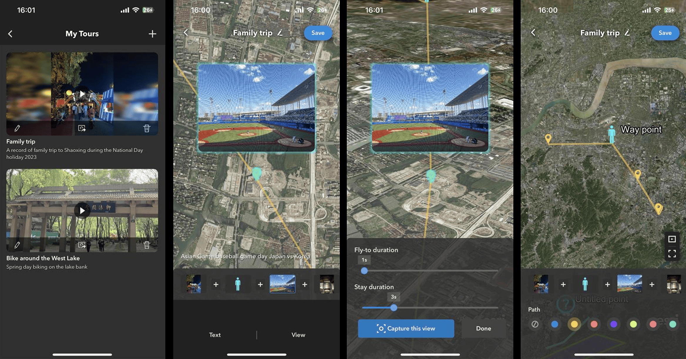
Enhanced Tour Experience
Have you tried creating a tour in ArcGIS Earth Mobile yet? If not, now is a good time to check it out. We spent a lot of time improving the tour creation user experience. You can create a tour using a collection of placemarks, geotagged photos, or a combination of both. Every point or image is a destination on your personalized journey. At each stop you can customize the fly-to and stay duration, set a camera view, and add captions. Capture and share your memories on an interactive 3D globe. You can use them to chronologically journal the progress of an urban development plan, prepare a virtual field trip, or as a digital footprint of a recent family vacation. Whatever your use case, tours provide a quick, easy, and modern way to communicate. Did I mention you can export them as videos directly on your device? Give it try and send us your feedback!
Closing Comments
That was quite a bit! I hope you are as excited as we are about these exciting new features and enhancements. As always, we welcome your feedback. Please submit feedback on the ArcGIS Earth Community page. From the whole product team, I hope everyone has a happy holidays and happy new year. There are many exciting things coming in 2024. Keep an eye out!


Commenting is not enabled for this article.