Integrating diverse data sources into a centralized GIS is critical for modern organizations managing spatial and non-spatial information. ArcGIS Enterprise offers a comprehensive solution for geospatial data management, mapping, and analytics. It is self-hosted, cloud-optimized, and secure, designed to both align with your IT standards and to integrate with other enterprise systems in your organization. With ArcGIS, organizations can create and share insights using easy-to-understand maps, apps, and reports that can be used to boost productivity, shared understanding, and efficiency.
ArcGIS Enterprise is unique because web layers can reference registered data in its source location, reading from and in some cases writing to, a user–managed data store. User-managed data stores can include relational databases, file folders, cloud storage, cloud data warehouses, and more. Alternatively, data can be copied to ArcGIS Enterprise and stored in the underlying system storage, resulting in a hosted web layer.
In this blog post, we explore several common methods for integrating data with ArcGIS Enterprise. While not exhaustive, this overview highlights the most widely used approaches, outlines typical use cases to help guide your integration strategy, and explains the key benefits of each method.
Let’s get started!
Quick links
Use the links below to navigate to a section of interest:
- Add data via the ArcGIS Enterprise portal
- Share data by reference from ArcGIS Pro
- Use the ArcGIS Data Interoperability extension
- Publish layers in bulk from relational databases
- Publish large datasets as scene or tile layers
- Automate integration with ArcGIS Python libraries
- Connect to any data source using custom data feeds
- Serve imagery using ArcGIS Image Server
- Stream real-time data with ArcGIS GeoEvent Server
- Share data using distributed collaboration

1. Add data via the ArcGIS Enterprise portal
A quick way to add data to ArcGIS Enterprise is directly from the source. The list of supported items that can be added to ArcGIS Enterprise is extensive. In ArcGIS Enterprise, you can add data from a variety of sources including Microsoft Excel, GeoJSON, shapefiles, service definition files, and more. Depending on the type of file you’re uploading, some file types, such as zipped file geodatabases and GeoJSON files, allow you to publish a hosted feature layer during upload, making the data immediately usable in web maps and apps.
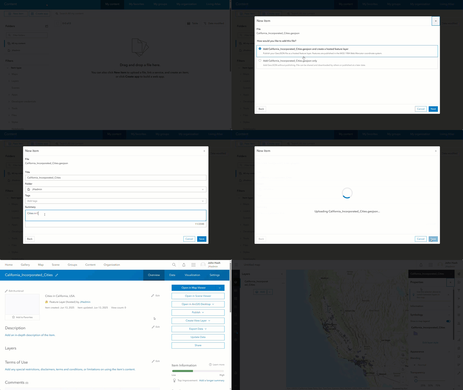
One thing to consider is that this method is best for static data that doesn’t require frequent updates. If the underlying data changes, the uploaded version in ArcGIS Enterprise will not automatically reflect those changes and would require either manual effort or a Python script to refresh the data. Additionally, this method typically assumes that the data is prepared and ready to use and does not require pre-processing to clean or format.
Best For: Users who require a quick, one-time method to bring static data into ArcGIS Enterprise as a hosted layer.

2. Share data by reference from ArcGIS Pro
Most, if not all, GIS professionals are using ArcGIS Pro. ArcGIS Pro is a desktop GIS application that plays a central role in preparing, analyzing, and integrating data with ArcGIS Enterprise. It offers tools for creating, modeling, and managing spatial data, performing advanced geospatial analysis, and building compelling cartographic products such as maps, map series, and layouts.
Whether you’re working in 2D or 3D, ArcGIS Pro makes it easy to share maps and data to the web, supporting a wide range of industries and sectors, from urban planning and environmental monitoring to public safety, utilities, transportation, retail, and more.
Users can publish web layers from ArcGIS Pro to ArcGIS Enterprise by referencing source data from a user-managed data store such as an enterprise geodatabase, relational database, cloud data warehouse, file share, or cloud storage location. This method avoids data duplication and ensures that maps and apps always reflect the most current information, as the web layer continuously accesses the original data source. Additionally, if the source data is stored in an enterprise geodatabase or a relational database, you can configure the web feature layers to support editing.
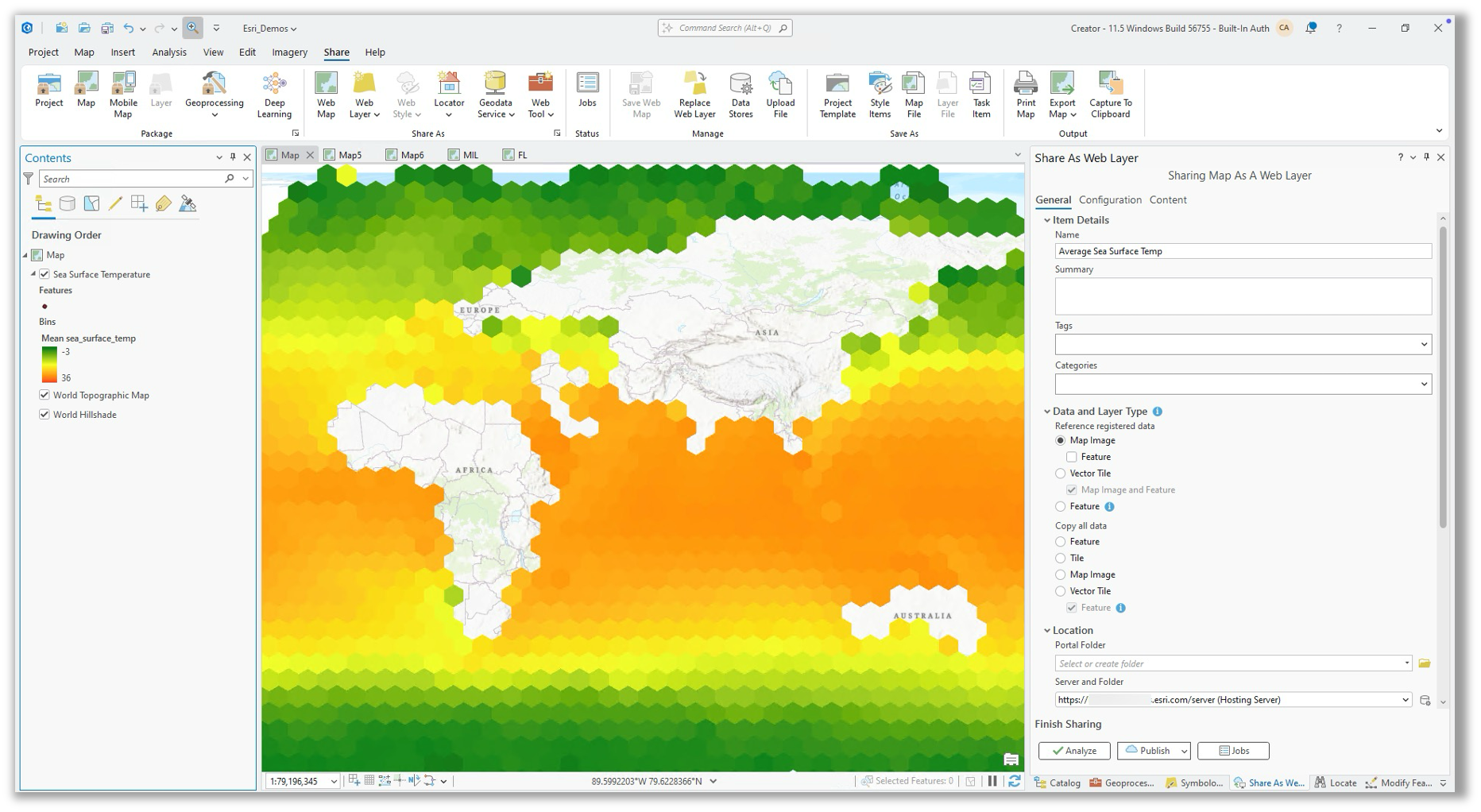
For example, a large retail firm that stores sales and store location data in a cloud data warehouse can use ArcGIS Pro to create a query layer that joins the latest sales figures to store locations. The query layer can then be shared to ArcGIS Enterprise and used in a dashboard that gives executives real-time insight into store performance. Because the web layer used in the dashboard references the source data in the cloud data warehouse, the dashboard will always be up to date.
ArcGIS Pro also allows users to publish layers to ArcGIS Enterprise with the option to copy all data. However, when data is copied during publishing it no longer references its original source. To learn more about how data is shared when publishing from ArcGIS Pro, refer to this documentation.
Best For: Publishers who want to share referenced web layers that maintain live connections to user-managed data stores.

3. Use the ArcGIS Data Interoperability extension
For more complex data transformation needs, consider using ArcGIS Data Interoperability. This licensed extension enables organizations using ArcGIS Pro and ArcGIS Enterprise to create complex ETL (extract, transform, and load) workflows without writing code. These workflows can be used to integrate data from file formats or data sources that are not supported natively, and it can also write data back to the source location outside of ArcGIS. In ArcGIS Pro, this extension provides users with an intuitive, visual diagramming interface that can be used to engineer data.
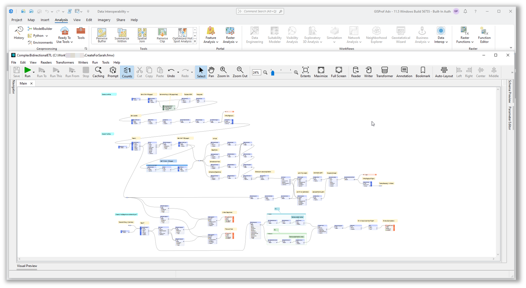
In ArcGIS Enterprise, the ArcGIS Data Interoperability server extension allows publishers to share their ETL workflows as a web tool (also referred to as a geoprocessing service). These can then be run ad-hoc by users of ArcGIS Enterprise, or they can also be scheduled to run at a later time or at an interval of the user’s choosing. Support for scheduling web tools was introduced with ArcGIS Pro 3.4 and ArcGIS Enterprise 11.4. For organizations working on earlier versions of ArcGIS Enterprise, web tools will need to be scheduled using a notebook and the ArcGIS API for Python.
If your organization is looking to integrate data from data sources that aren’t supported natively in ArcGIS, and/or need to do complex data preparation workflows and data transformations, this extension will provide you with the powerful data engineering capabilities that you might be seeking.
Best For: Data engineers or GIS analysts building complex ETL workflows who desire a no-code solution.

4. Publish layers in bulk from relational databases
For organizations seeking a streamlined method to publish map image and feature layers that reference data from a relational database, bulk publishing is a solution to consider. As the name suggests, bulk publishing allows you to publish many feature classes or tables as web layers simultaneously, simplifying the process significantly.
This process begins with creating a database connection file (.sde) in ArcGIS Pro for an enterprise geodatabase or relational database. The file is then added as a data store item to ArcGIS Enterprise. Once created, the data store item’s owner can navigate to the item page and select the option to create layers from the Layers tab.
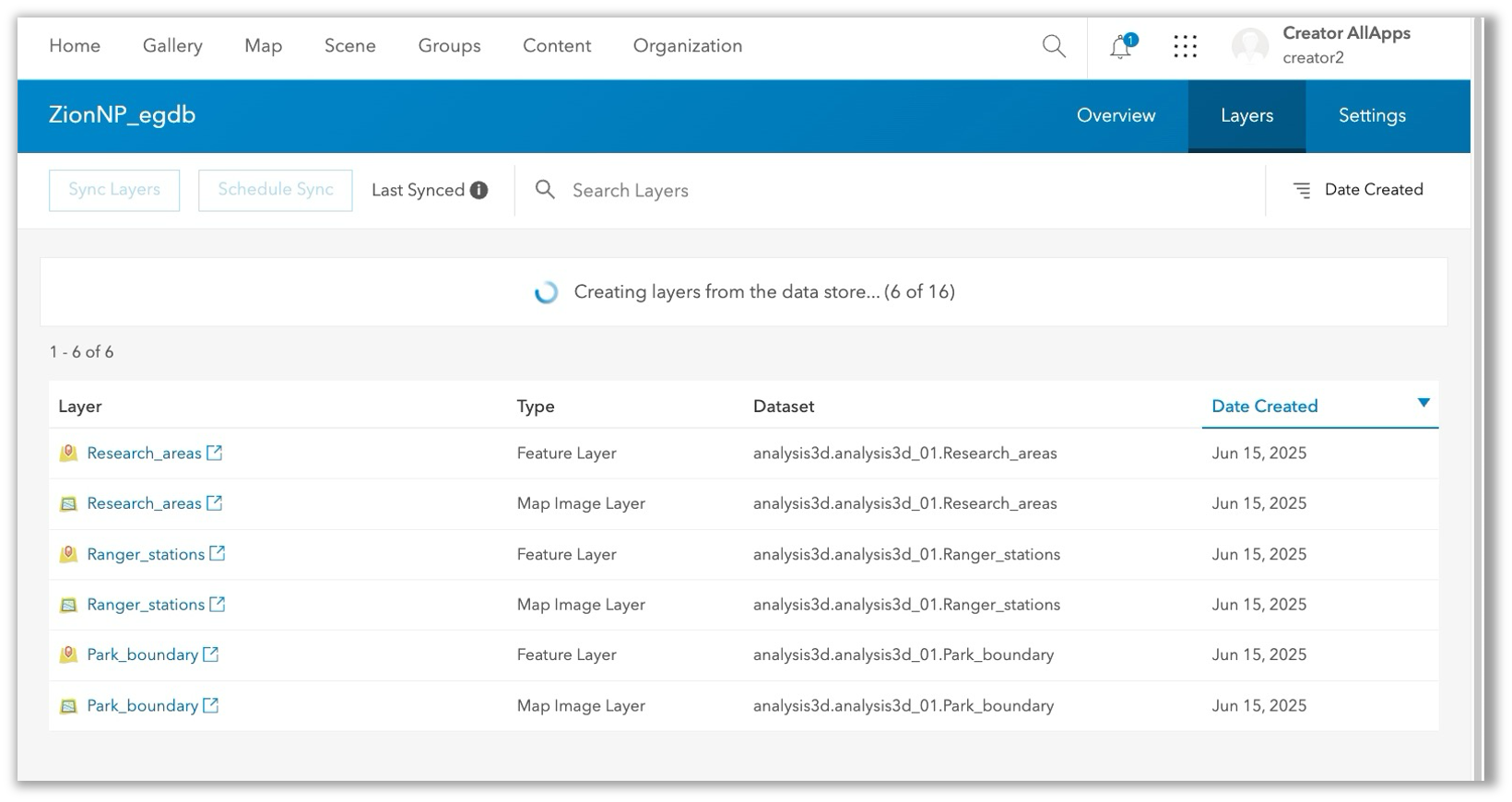
The number of web layers generated depends on the number of feature classes and tables accessible through the database connection. For each dataset, both a map image layer and a feature layer item will be created. Editing and sync will not be enabled on the feature layer to start, but the publisher can enable it from the ArcGIS Enterprise portal or in ArcGIS Server Manager.
Given that all data is published through this workflow, it is crucial to carefully consider which datasets the user specified in the connection file can access. Ensuring appropriate access and privileges for the database user is essential to avoid unintended data exposure.
To learn more, see: Publish layers in bulk from a user-managed data store.
Best For: Database administrators or GIS managers who want to streamline publishing web layers by reference from a relational database.
5. Publish large datasets as scene or tile layers
Organizations that need to publish a very large scene layer, 3D tiles layer, vector tile layer, or (raster) tile layer to ArcGIS Enterprise can do so efficiently and at scale by staging the cached content in a network folder or cloud storage location and then publishing the web layer directly from the Enterprise portal. This is an alternative to sharing directly from ArcGIS Pro or uploading a package to ArcGIS Enterprise, which results in a hosted web layer. Instead of the web layer being hosted, it dynamically references the cache contents from a user-managed data store.
This workflow involves:
- Using the Extract Package tool in ArcGIS Pro (2.8 or later) to generate the ready-to-serve cache content.
- Staging the output in either a folder or cloud storage location that is then registered as a data store.
- Choosing the appropriate layer type from the Content > New Item page and browsing to the dataset from within the registered data store.
This approach is beneficial as it reduces publishing time for large datasets that would otherwise take hours or days to process, and it also preserves disk space in the portal content directory and hosting server’s object store.
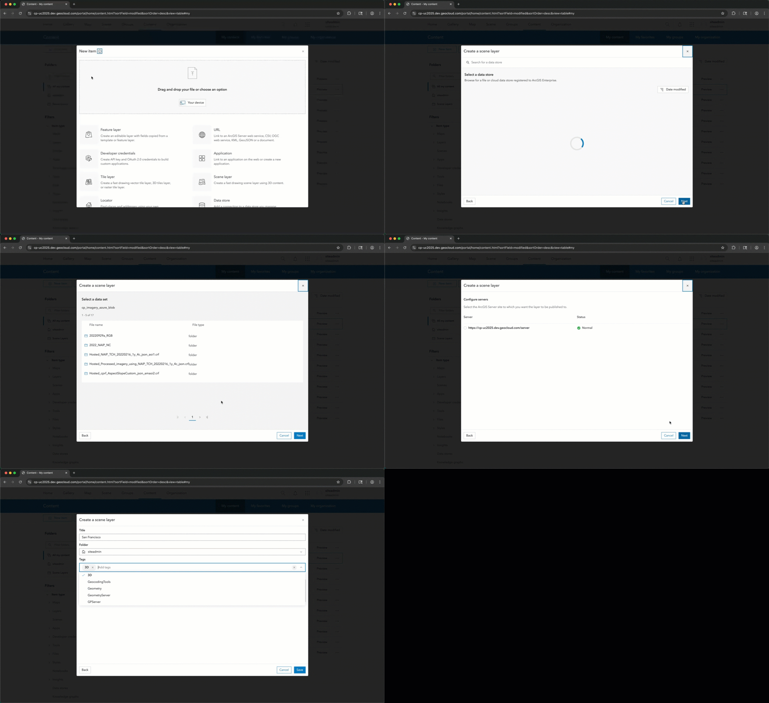
To learn more, refer to the documentation for the layer type you are interested in publishing: scene layer, 3D tiles layer, raster tile layer, or vector tile layer.
Best For: GIS professionals looking to optimize resources when publishing very large (multiple gigabytes in size) scene layers or tile layers to ArcGIS Enterprise.
6. Automate integration with ArcGIS Python libraries
For users with Python scripting skills, ArcGIS API for Python and ArcPy can be used to integrate data with ArcGIS Enterprise. These are two ArcGIS Python libraries that allow users to integrate data from a vast array of sources and perform advanced geospatial analytics using a programmatic approach. In addition to data integration, the ArcGIS API for Python can also support organization administration, content management, spatial analysis, and data science workflows in ArcGIS. Using Python to support data integration workflows requires more advanced skills but may be preferred over no-code ETL tools when you require additional flexibility or want to avoid obtaining additional software.
ArcGIS Enterprise includes a solution for writing, running, and even scheduling Python scripts that use ArcGIS Python libraries, which is ArcGIS Notebooks. ArcGIS Notebooks simplify automation and make tasks like authentication, collaborating on scripts, and adding content and tools to the script, easier.
For example, a city’s public works department could use the ArcGIS API for Python to download a CSV file from a URL and publish it as a web layer to ArcGIS Enterprise.
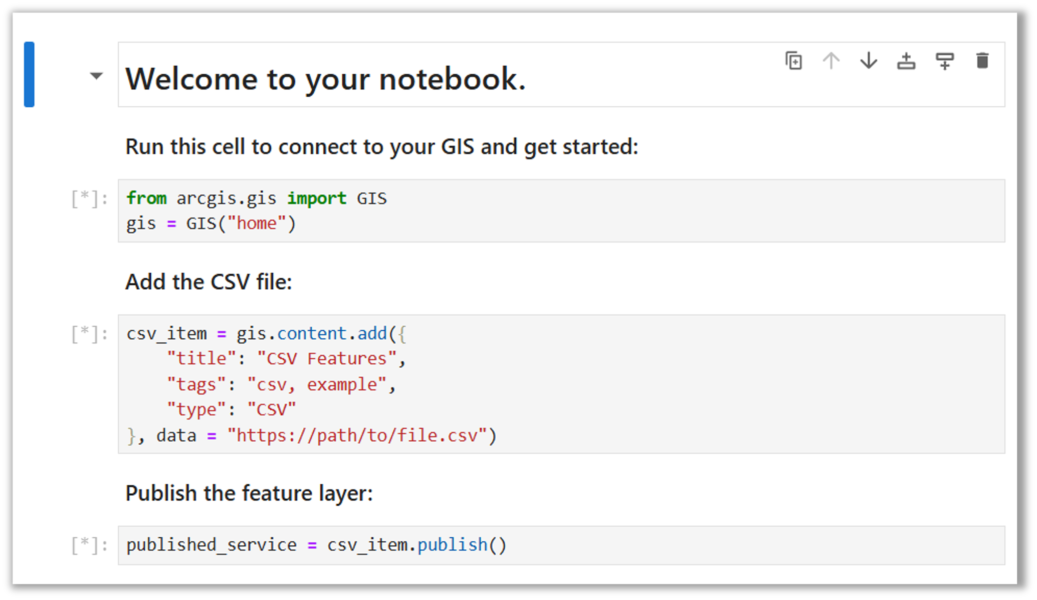
To update the data in ArcGIS Enterprise, a notebook author could update their script to overwrite a web layer in their content and schedule it to run weekly. While ArcGIS Notebooks offers many benefits, as it is fully integrated with ArcGIS Enterprise, scripts that leverage ArcGIS Python libraries can also be written and run external to ArcGIS Enterprise as well.
If your data integration solution requires customization beyond what other built-in tools or ETL solutions can offer, consider using ArcGIS Notebooks and the ArcGIS Python Libraries.
Best For: Users with Python expertise looking to automate data preparation and integration workflows using code.
7. Connect to any data source using custom data feeds
Custom data feeds is a powerful scripting-based solution for integrating data with ArcGIS Enterprise that is not supported natively. With custom data feeds, organizations can create a feature layer that brings in data from virtually any source, such as a proprietary REST API, public URL, or a database like MongoDB. This approach can serve as an alternative to traditional ETL workflows and is especially useful when data must remain in its original system and be accessed in real time.
This extensibility option relies on the ArcGIS Enterprise SDK and allows developers to write custom code that matches their integration needs. Using the custom data feeds command line tool, a developer can create, test, and package a custom data provider that allows ArcGIS Enterprise to connect to the data source of interest. These are written in Node.js, a popular and feature-rich JavaScript runtime environment that excels at handling large numbers of concurrent requests. Custom data providers are then registered with ArcGIS Enterprise (or a stand-alone ArcGIS Server site) and used to create feature services.
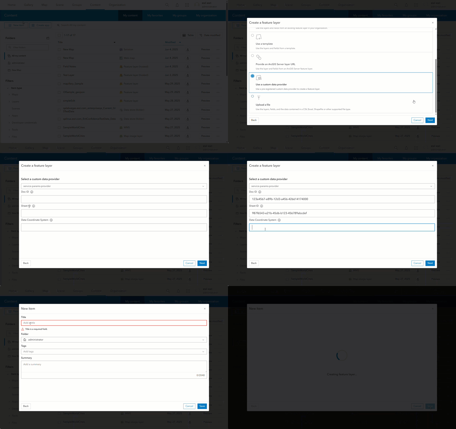
In ArcGIS Enterprise, feature layers created using custom data feeds can be consumed in ArcGIS clients and custom applications and used to support visualization, analysis, and editing workflows similar to other feature layers. The editing capability added in ArcGIS Enterprise 11.4, allows for directly editing the data in the original location, keeping feature layer accurate and up to date.
Best For: Organizations needing to integrate data sources with geometry types that follow the GeoJSON specification or are not natively supported by ArcGIS Enterprise who want to avoid data duplication and ETL.
8. Serve imagery using ArcGIS Image Server
ArcGIS Image Server extends ArcGIS Enterprise with image management and raster analytics capabilities, helping organizations integrate, manage, and analyze large collections of imagery and raster data. Users can publish dynamic image services from mosaic datasets using ArcGIS Pro, enabling pixel-level queries, on-the-fly raster processing, and advanced raster analytics. This approach is similar to Way #2 but allows for mosaic datasets to be shared as a referenced imagery layer to ArcGIS Enterprise. Source imagery referenced in the mosaic dataset can be stored in file system storage or cloud storage.
Publishers of an image service can determine what functionality will be available to the end users of the web layer. For example, a mosaic dataset can be published as a dynamic image service with embedded raster processing templates to allow for on-the-fly processing of digital surface models (DSMs) and other raster data.
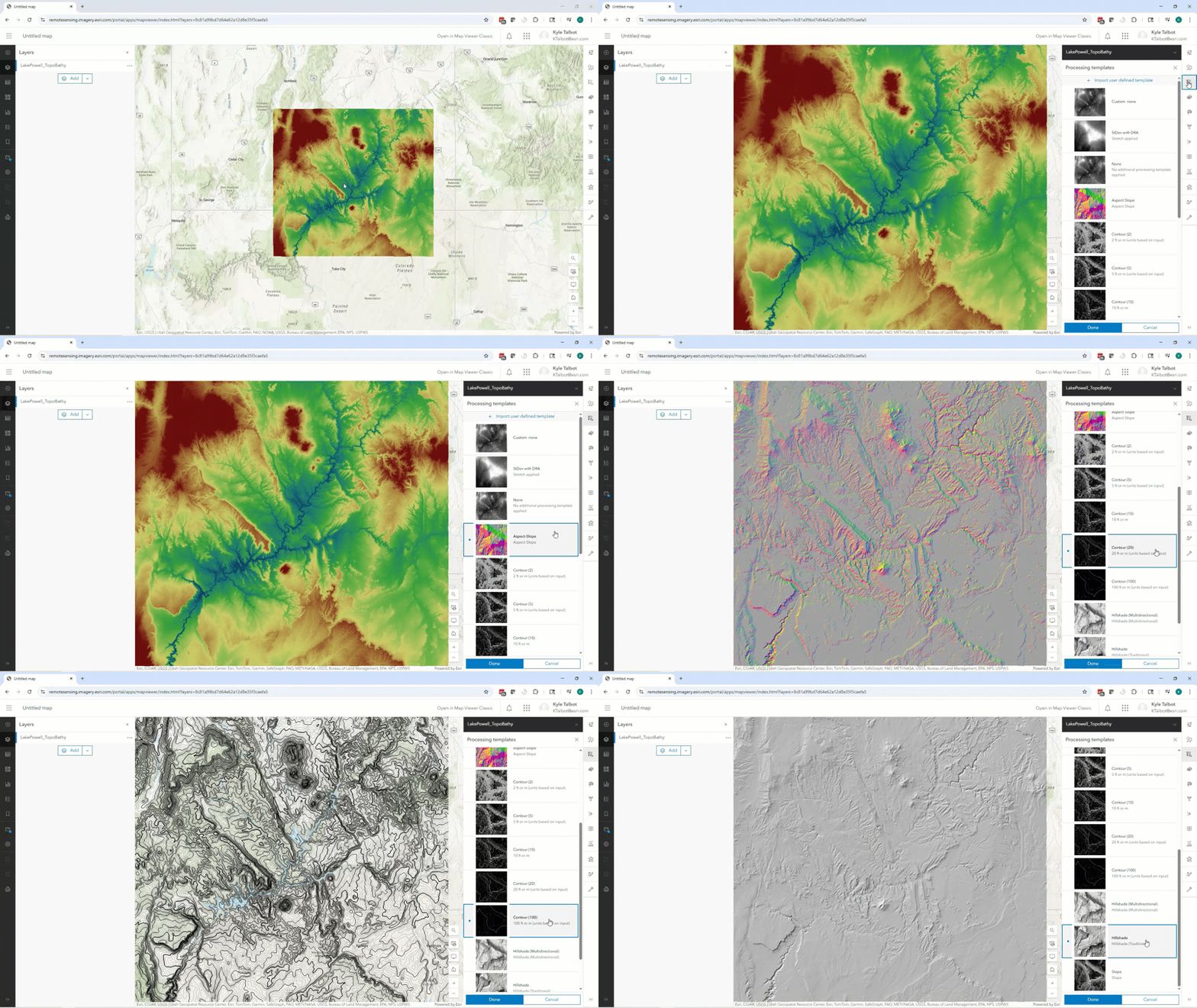
In addition to serving imagery, ArcGIS Image Server enables raster analytics, a distributed processing framework that allows organizations to perform large-scale image analysis across multiple machines over the web. This supports analytical workflows like change detection, suitability modeling, hydrologic analysis, deep learning-based classification, and more.
Whether you’re serving imagery for visualization or analysis, ArcGIS Image Server helps organizations bring imagery, elevation, and other raster datasets to the center of their operations. Please note, publishing single raster datasets as imagery layers to ArcGIS Enterprise does not require ArcGIS Image Server.
Best For: Organizations who need to manage, share, or analyze large collections of imagery or raster data.
9. Stream real-time data with ArcGIS GeoEvent Server
ArcGIS GeoEvent Server enables real-time event-based data streams to be integrated with ArcGIS Enterprise and used to update feature services. Event data can be filtered, analyzed, and sent to multiple destinations concurrently, enabling faster response times, automated notifications, and more effective decision making. For example, airports can integrate real-time flight position data with their enterprise GIS to enhance situational awareness and streamline daily operations such as gate assignments, runway scheduling, and emergency response. Historical flight path observation data can also be visualized and analyzed in ArcGIS uncovering patterns and supporting geospatial analytics.
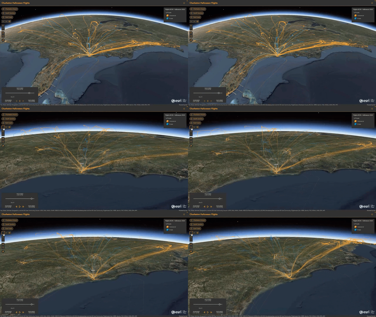
Unlike other integrations mentioned here, ArcGIS GeoEvent Server is event driven and works based on a “push” rather than a “pull” model, meaning that data is brought into ArcGIS Enterprise without having to make requests for it. Once the event-based data stream is deployed, clients do not need to continuously request updates, as new data is pushed automatically into the system. Common data formats and data streams from IoT sensors, GPS devices, and other push feeds on the internet are natively supported, including TCP, MQTT, RSS, and HTTP.
GeoEvent also includes powerful tools for analytics, such as dynamic geofencing and visual analytic models that can be used to gain new insights, including support for alerts that can communicate actionable information when time is of the essence.
If real-time situational awareness, such as tracking moving assets or monitoring stationary sensors in the field is a need for your organization, then integrating live data feeds into ArcGIS Enterprise using ArcGIS GeoEvent Server is the solution for you.
Best For: Organizations who want to enable real-time solutions by integrating data from IOT sensors and other live data feeds.
10. Share data using distributed collaboration
If your organization needs to share content with other ArcGIS Enterprise or ArcGIS Online organizations, distributed collaboration provides a secure and scalable solution. It allows organizations to sync data and content across systems, whether between departments, agencies, or partner organizations, without relying on manual file transfers or email attachments.
Distributed collaboration, or simply collaboration, works by linking groups across organizations. Once configured by administrators, users can share content to a group, and that content is automatically synced to the corresponding group in the partner organization. This makes it easy for teams to work from a common, up-to-date source of truth.
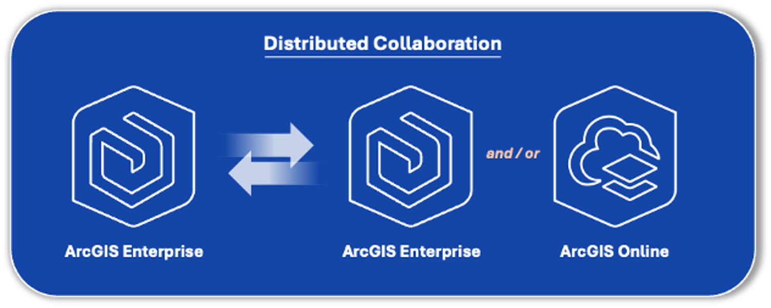
For example, a city’s GIS department can collaborate with neighboring counties by creating a shared group tied to a collaboration. Each participant accesses the latest data through their own ArcGIS environment, eliminating the need for redundant copies or File Transfer Protocol (FTP) sites.
To learn more about the types of collaborations in ArcGIS, including distributed collaboration, please see: Understand collaborations.
Best For: GIS managers or administrators coordinating multi-agency or cross-departmental projects who need secure, automated data sharing between ArcGIS organizations.
Bonus: Streamline data preparation workflows using ArcGIS Data Pipelines (Coming Soon!)
Need to bring data into ArcGIS Enterprise from a public API or files stored in Amazon S3 or Azure Blob Storage—without writing code? Well, data preparation workflows like these will become much easier in ArcGIS Enterprise when ArcGIS Data Pipelines is available.
ArcGIS Data Pipelines is a native data integration capability that is in ArcGIS Online today. It has helped thousands of organizations prepare and integrate data from various sources to create and maintain feature layers in their ArcGIS organization. It provides users with an intuitive, visual drag-and-drop interface that reduces the need for coding skills and repetitive manual effort and helps organizations increase the quality and readiness of data for use in their visualization and analysis workflows.
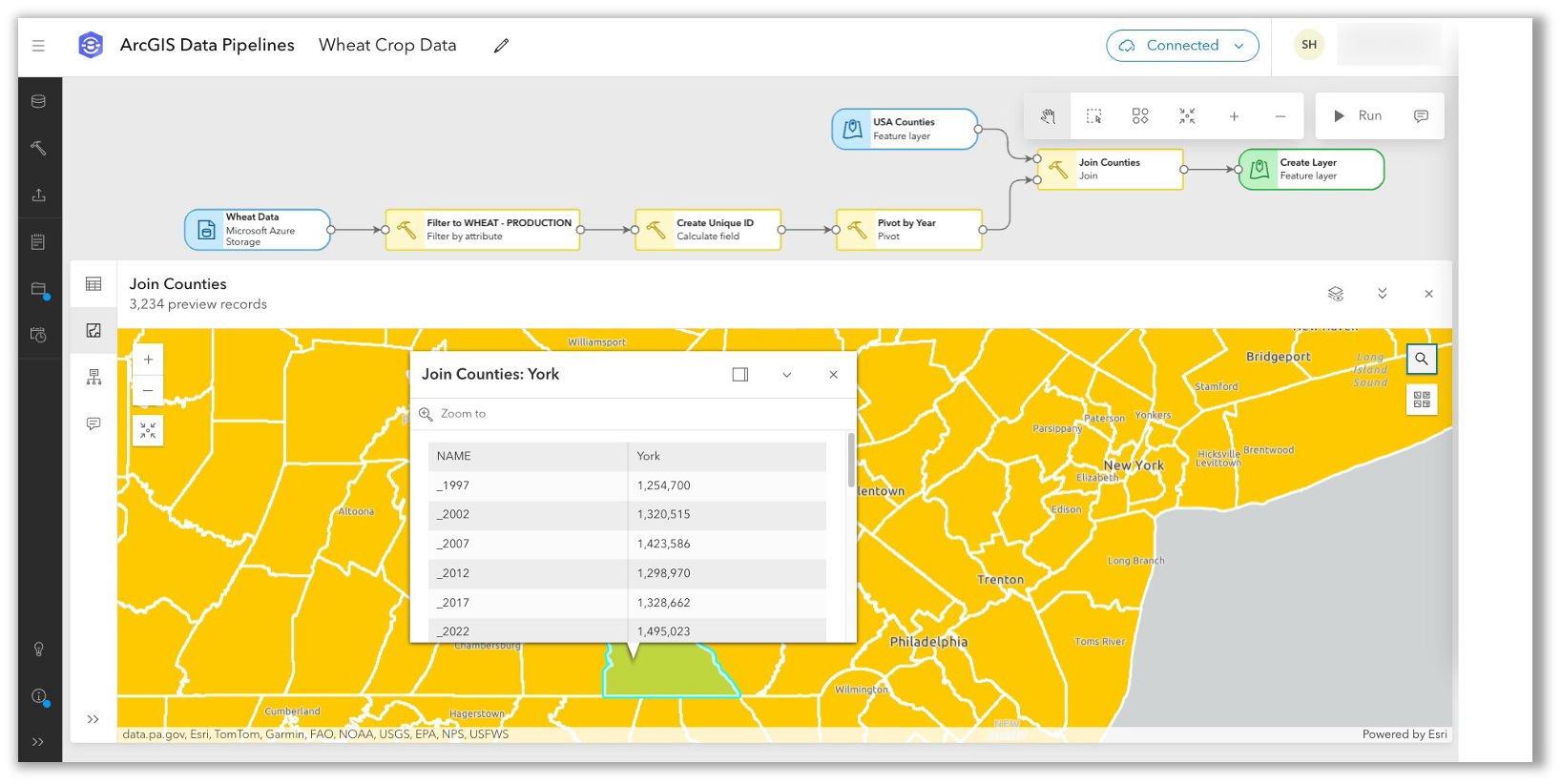
More information will be available soon. In the meantime, feel free to ask questions, submit ideas, or engage with the product team via Data Pipelines Community.
(Will Be) Best For: Organizations seeking a no-code solution to integrate and transform data into a ready-to-use state for visualization and analysis in ArcGIS Enterprise.
Conclusion
In this blog, we learned ten ways to integrate data with ArcGIS Enterprise. Once integrated, your data can be used to perform spatial analyses, create visually stunning maps, and solve problems. Keep in mind that the right approach will depend on your project’s unique requirements and the organization’s goals.
Explore some of these strategies today to begin unlocking the full potential of your data within ArcGIS Enterprise and drive more impactful outcomes.
To learn more, please see this related Community Blog for a list of additional resources. Additionally, if you have any questions or ideas, please share them to Esri Community.


Commenting is not enabled for this article.