Asset management has become one of the most important priorities for water utilities today. Aging infrastructure, workforce retirements, climate pressures, rising customer expectations, and increasing regulatory requirements are forcing utilities to make better decisions about where and how they invest limited resources.
I’ve worked with utilities of all sizes, and while every organization’s circumstances are different, the challenges they face are remarkably similar. Most know what they want to achieve: reduce risk, improve reliability, extend asset life, optimize spending, and make smarter investment decisions. Yet many struggle to move beyond the early stages of asset management maturity.
The problem is rarely a lack of effort.
Utilities have invested heavily in geographic information system (GIS) technology, computerized maintenance management systems (CMMS), hydraulic models, financial applications, inspection programs, and reporting processes. Mobile crews collect data, engineers assess infrastructure, managers develop budgets and capital plans, and compliance teams track regulatory requirements. Across the organization, people are working hard to support better asset management and serve their communities.
The challenge is that the information needed to make confident decisions remains scattered and oftentimes disconnected across systems, departments, and workflows.
I’ve found that most utilities don’t have a data problem. They have a visibility problem. Asset records, maintenance histories, inspection results, financial information, and field observations often exist in different locations, making it difficult to see the complete picture. Without a shared understanding of infrastructure performance, decisions become reactive, priorities become harder to defend, and planning becomes increasingly difficult.
Modern GIS changes that dynamic.
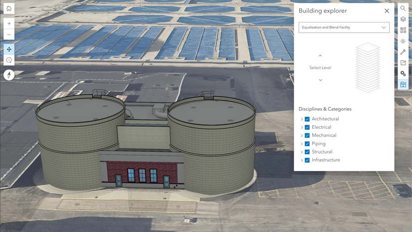
By bringing together asset records, field observations, condition assessments, work history, risk factors, and operational context, GIS creates a connected foundation for asset management. It helps utilities transform scattered information into shared intelligence and move from reactive maintenance to proactive, risk-based decision-making.
Why Asset Management Programs Stall
Fragmented Systems Limit Visibility
Utilities rely on multiple systems to manage infrastructure. GIS tracks asset locations, work management systems document maintenance, financial systems store asset values, and inspection programs capture condition information. Problems arise when these systems operate independently.
Staff may spend hours reconciling conflicting asset locations, counts, installation dates, and maintenance records. These silos make it difficult to prioritize work, justify investments, support regulatory reporting, and develop long-term plans.
Modern GIS creates a shared operational view by connecting information across systems and departments. This allows staff to spend less time searching for answers and more time acting on them.
Incomplete Records Create Uncertainty
Many utilities are still developing comprehensive asset inventories. Records may lack installation dates, materials, condition ratings, ownership details, maintenance histories, or criticality scores. These gaps make it difficult to evaluate risk, forecast investments, and establish replacement priorities.
Incomplete records also increase reliance on institutional knowledge. As experienced employees retire, undocumented knowledge about repair patterns, system history, and critical assets can disappear. Capturing this knowledge within an authoritative GIS helps utilities preserve valuable context and support consistent decisions.
Inconsistent Field Updates Reduce Confidence
Field crews often have the clearest understanding of current system conditions. However, paper forms, spreadsheets, emails, and delayed office updates can prevent their observations from reaching enterprise systems.
Mobile applications such as ArcGIS Survey123 allow staff to complete inspections, update asset information, document defects, attach photos, and submit observations in real time.
Limited Condition Data Keeps Programs Reactive
Location alone does not reveal which assets are most likely to fail or which failures would create the greatest consequences. Utilities collect condition information through inspections, testing, leak records, service requests, and maintenance activities, but that information often remains disconnected.
GIS provides the spatial framework for combining condition data, maintenance histories, environmental factors, and consequences of failure. This context helps utilities understand risk, prioritize work, and address emerging problems before they become more serious.
Limited Visibility Slows Alignment
Operations, engineering, maintenance, finance, compliance, customer service, information technology, and executive leadership use infrastructure information differently. When teams rely on disconnected data, their priorities can diverge.
Modern GIS creates a common operating picture through web maps, dashboards, mobile applications, and analytics. Staff can review asset histories, managers can track performance, leadership can evaluate risk, and compliance teams can access supporting documentation.
The Path Forward
Asset management maturity develops through continuous improvement. Utilities strengthen it by improving data quality, connecting systems, standardizing workflows, and using trusted information to guide decisions.
Utilities do not need perfect data to begin. They can start with existing information, address priority gaps, improve field data collection, and build a shared understanding of infrastructure performance.
Modern GIS provides the connected foundation needed to reduce risk, improve reliability, optimize investments, preserve institutional knowledge, and prepare for future infrastructure needs.
Save the Date
Explore a new eBook showcasing how leading water utilities are using modern GIS to strengthen asset management and make more confident infrastructure decisions.
Asset Management: Enabled by Modern GIS
October 26, 2026

Article Discussion: