ArcGIS Indoors enables organizations to build an indoor GIS and makes the power of indoor mapping, space planning, and navigation available to everyone. Key patterns of use include asset management, space management, safety and security, and occupant and visitor experiences.
Since the start of 2026, the ArcGIS Indoors releases include:
| Component | Release Versions |
| ArcGIS Indoors for ArcGIS Online | February 2026 & June 2026 |
| ArcGIS Indoors Mobile app | v2.2 in March 2026 & v2.3 in July 2026 |
| ArcGIS Indoors for ArcGIS Pro | 3.7 in May 2026 |
| ArcGIS Indoors for ArcGIS Enterprise (Windows/Linux) | 12.1 in May 2026 |
| ArcGIS Indoors for ArcGIS Enterprise (Kubernetes) | 12.1 in June 2026 |
These releases advance ArcGIS Indoors across five strategic themes: simplifying data curation so more organizations can adopt indoor GIS, making indoor environments more immersive through indoor reality capture, delivering a more seamless occupant experience, enabling more optimized space management, and expanding AI to where indoor GIS is going.
Jump to specific topics:
| Theme | Features |
| One: Indoor mapping is becoming easier | – Importing floor plans from PDF |
| – PDF enhancements in ArcGIS Pro | |
| Two: Indoor GIS is becoming immersive | – From capture to clean, usable indoor imagery |
| – 360 photo mobile capture | |
| Three: Occupant experience is becoming seamless | – Indoors App Clip |
| – Events | |
| – Geometry-aided positioning | |
| Four: Space management is becoming more optimized | – Expanding reservation options |
| – Scheduling limits for office hotels in hours | |
| Five: AI is expanding where indoor GIS is going | – Turning extracted data into app-ready floor-aware maps |
Theme 1: Indoor Mapping is Becoming Easier
Lower the barrier to indoor GIS adoption by simplifying and making it easier for more organizations to create and maintain high-quality indoor floor plans, regardless of starting point or technical skill.
Importing Floor Plans from PDF: Making Indoor Mapping Easier on the Web
- Released in May 2026 with ArcGIS Enterprise 12.1
- Released in beta in June 2026 with ArcGIS Online
PDF is a widely used file format to easily view and share floor plans. It is viewable across different devices without the need for specialized software. Following the support for importing floor plans from CAD and BIM files last year, the ArcGIS Enterprise 12.1 release and ArcGIS Online June update of Floor Plan Editor now supports importing floor plans from PDF, making indoor mapping easier and more accessible to non-GIS professionals such as facilities and operations staff, school administrators, and emergency response teams.
Floor plans in a PDF file are mainly found in two formats – vector or raster. PDF files exported from specialized software used for construction design or graphics are vector. The lines representing the floor plan and the text information on it are stored as-is and they look sharp no matter how much you zoom in. On the other hand, PDF files created by scanning a paper-based floor plans or by saving as or converting an image file are raster. Most of the time, the included lines and text may appear pixelated when you zoom in to view the details.
The Floor Plan Editor app can now import floor plans from vector PDFs. The process is easy – simply upload the PDF and specify the page number that contains the floor plan. Optionally, you can define a processing boundary to exclude other information like a paragraph of text or a legend that might exist on the page.
PDF Enhancements in ArcGIS Pro
- Released in May 2026 with ArcGIS Pro 3.7
Initial support for converting PDF floor plans into floor-aware indoor maps was released at ArcGIS Pro 3.6. The ArcGIS Pro 3.7 release has added enhancements to the workflow to reduce effort and improve the quality of resulting datasets.
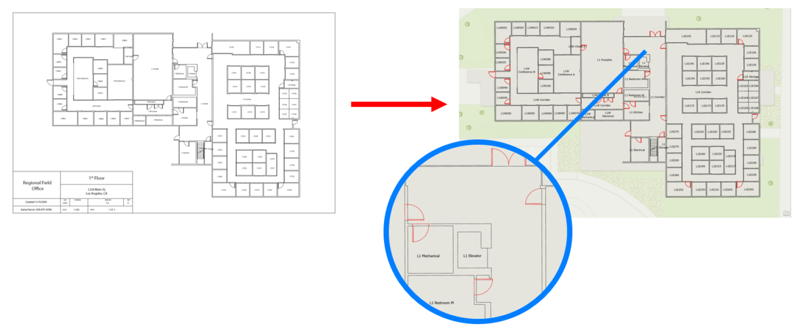
You can now extract features directly from vector PDFs, preserving the fidelity of the original floorplans and eliminating the need for rasterization. For raster-based plans, extraction has been refined to generate linework along centerlines, producing cleaner and more usable geometry.
In addition, text can now be extracted from PDFs into point features. This creates a structured representation of room labels and other annotations that can be immediately reused for attribution. Extracted text can be mapped directly to unit attributes during import, reducing the need for manual editing and accelerating the creation of fully attributed datasets.
These enhancements simplify what has traditionally been a manual, error-prone process, helping you go from source documents to a high-quality indoor GIS faster and more easily.
Theme 2: Indoor GIS is becoming immersive
Build immersive indoor environments without specialized hardware by bringing commercial-grade reality capture to everyday GIS workflows.
From Capture to Clean, Usable Indoor Imagery
- Released in May 2026 with ArcGIS Pro 3.7
While some scenarios demand point clouds and professional-grade location accuracy for captured photos, not every use case requires that level of precision. In many situations, the ability to add 360° photos to an Oriented Imagery dataset using a consumer-grade device (with accuracy measured in feet rather than inches) is not only sufficient, but a significant accelerator for building an indoor photo reality.
ArcGIS Pro 3.6 introduced a new tool – 360 Video To Oriented Imagery – which enables rapid indoor capture by recording a 360° video and automatically extracting geolocated frames with directional context. These images are then added to a floor-aware oriented imagery dataset, significantly streamlining what was previously a manual, time-consuming, and error-prone process, especially in environments where GPS is unreliable. ArcGIS Pro 3.7 includes enhancements to this tool that make it easier to turn 360° video into high-quality indoor imagery that’s ready for use across mapping and validation workflows while reducing the overhead of working with large amounts of data.
The tool now supports time-compressed video, allowing teams to capture the same spaces in shorter recordings, significantly reducing storage requirements on devices and speeding up processing. This is especially valuable when working across large facilities or campuses, where traditional video capture can quickly become heavy and time-consuming to manage.
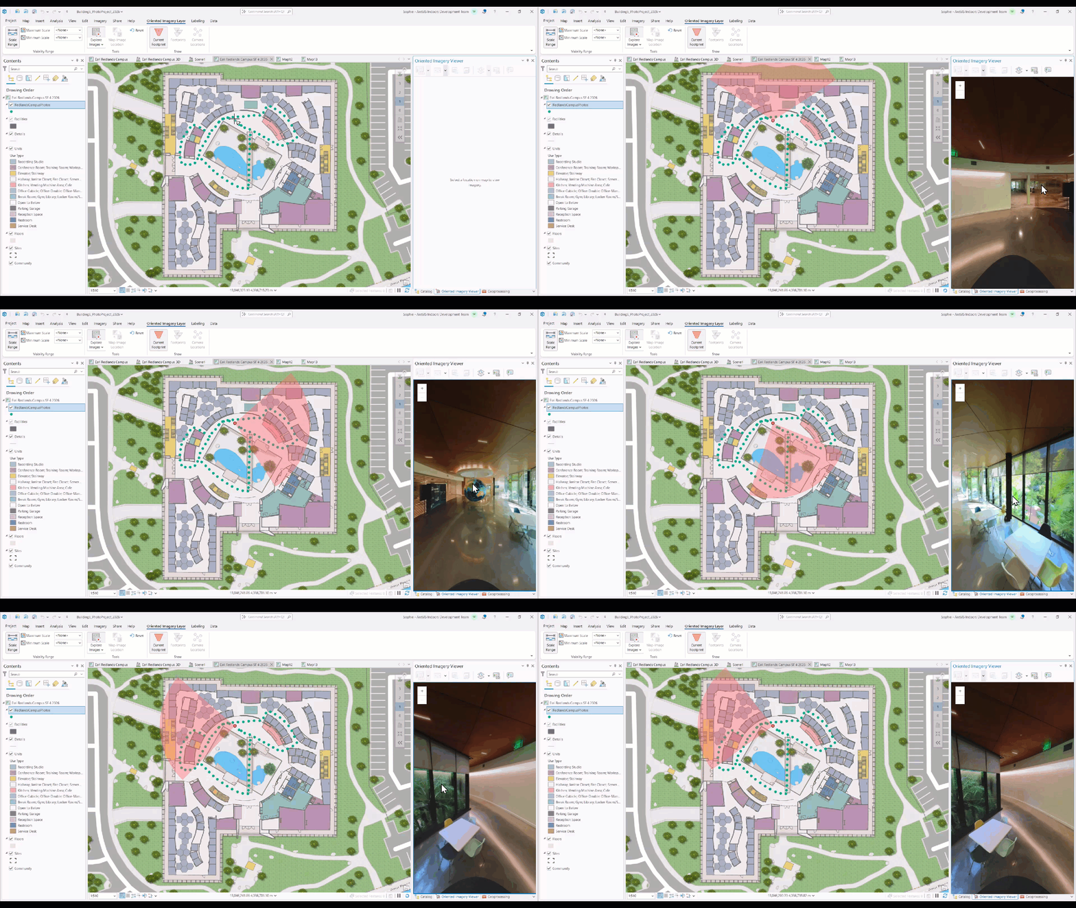
A new option to mask the camera operator from extracted frames assists in producing cleaner imagery without additional editing. The tool also provides configuration options for setting floor awareness, providing more flexibility in the integration of oriented images with the Indoors data model. Together, these improvements streamline one of the fastest ways to capture indoor environments – making it more scalable, efficient, and easier to operationalize.
360 photo mobile capture
- Released in July 2026 with ArcGIS Indoors Mobile v2.3
While the update in ArcGIS Pro described above helps with creating a 360-photo series through continuous capture by walking along a path with a 360 camera, organizations also have a need to capture-specific and discrete 360-photos associated to a location. For example, IT and Operations teams would want to capture 360° photos per room for asset location and condition assessment and Facilities and Maintenance teams would need them for inspection of a specific area and facility workers can see a 360-view of the room to become familiar with the space and bring necessary equipment before they arrive to service a work order.
The v2.3 update of Indoors Mobile includes the ability to directly connect with consumer-grade 360° cameras to capture 360-photos and directly associate it with a specific location on the indoor map. This workflow eliminates the time-consuming process of capturing and cataloging individual photos and manually downloading each photo to the workstation and then uploading it as an attachment to the oriented imagery layer by associating each photo to a location on the indoor map.
To get started, all you need is to sign in to Indoors Mobile with a user account with editing privileges, open a mobile map with a floor-aware oriented imagery layer, and a 360-camera like the Insta360 X5 or GoPro Max2. It is recommended to use a tripod, that is already lightweight and portable, to setup the 360-camera at or near the center of the room for a clear and unobstructed view and walk away to a spot outside the frame, and specify the location and orientation of the camera on the indoor map and initiate the capture.
Theme 3: Occupant experience is becoming seamless
Deliver frictionless, intuitive experiences for occupants, visitors, and field workers.
Indoors App Clip: Transforming the Visitor Experience
- Released in February 2026 with ArcGIS Online
We have all been in a situation where it is required to download an app for a quick and less frequent task like paying for parking or placing a pick-up order at a sandwich or coffee shop when visiting a new city. The app itself is very useful and provides additional benefits like parking expiration reminders or loyalty rewards for food or beverage purchases but we hesitate as it feels too much effort to download the app. Instant access without having to download the full app is great solution for such situations.
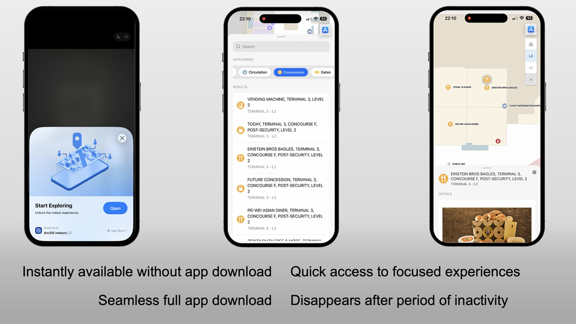
ArcGIS Indoors Mobile now includes the Indoors App Clip. It provides users instant access to indoor maps, without having to first download the Indoors mobile app. By simply scanning a QR code, users can launch an App Clip on an iOS device within seconds and get a full screen app-like experience. Users with an Android device can scan the same QR code and get instant access to the indoor map through a progressive web app.
You can now instantly provide visitors like travelers at an airport, parents of a student at a university campus, first time patients or family members at a hospital or jurors at the courthouse with an interactive floor-aware indoor map to quickly find places and things and get directions right when they need it and seamlessly allow them to download the app if they would like to access additional capabilities.
Events: Connecting people with places and experiences
- Released in July 2026 with ArcGIS Indoors Mobile v2.3
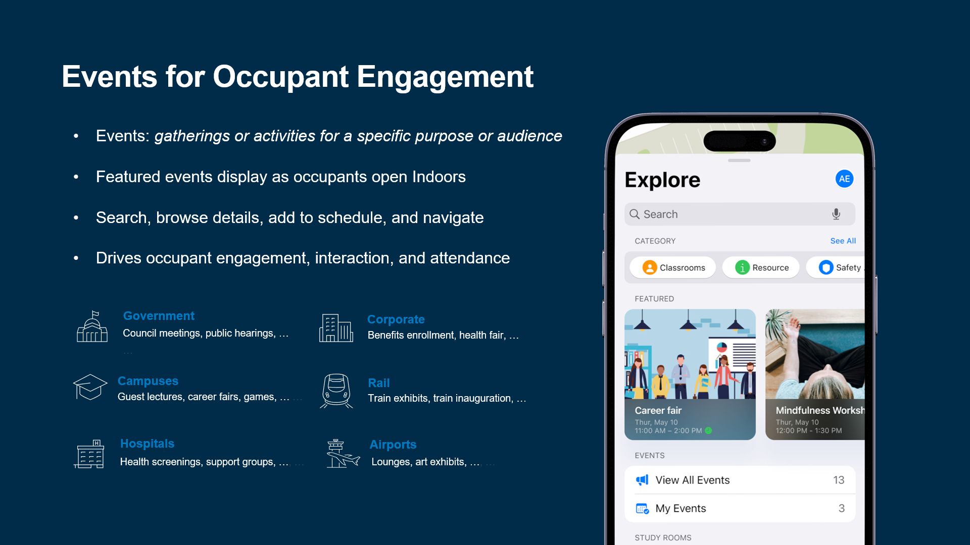
Events are gatherings or activities for a specific purpose or audience. They are an excellent way to bring people together, have them engage in activities, learn new things and more. Companies have events to enhance team collaboration or share information about workplace benefits. Universities organize events for career fairs, research symposiums and alumni gatherings. Hospitals have events for health awareness and well-being,
With ArcGIS Indoors, organizations can provide a curated list of events and organize them by categories for easy exploration. Event organization teams can also mark certain important events like all-hands meeting at a company or a free screening for biometrics or vitals at a hospital or a university as ‘Featured events’ so they are easily discoverable. In addition to events that are located inside buildings, events that are outdoors or offsite and even online events that can be joined virtually can also be included.
It is possible to be overwhelmed if there are many events happening around you and maybe also during the same time but with Indoors mobile, users can easily browse and filter events, see details and get directions to them. They can even save events they plan to attend for quick access and a way of planning their visit in advance. Including events transforms your ArcGIS Indoors deployment into a dynamic engagement platform that connects people with places and experiences.
Geometry-Aided Indoor Positioning: Enhancing Indoor Navigation
- Released in November 2025 in ArcGIS IPS for ArcGIS Pro 3.6
- Released in March 2026 with ArcGIS Indoors Mobile v2.2
Geometry-aided indoor positioning uses floor plan elements, such as walls and columns, to refine indoor position by preventing movement that crosses physical barriers or extends beyond specified areas. This gives users an enhanced blue dot experience.
Setting up geometry-aided positioning involves adding traversability information to the indoor positioning dataset using the new Add Geometry To Indoor Positioning Dataset tool in ArcGIS Pro 3.6, specifying positioning areas, obstacles, entry and exit points, and sharing as an IPS aware map.
The mobile map (mmpk) meant for the Indoors Mobile app will need to be updated and downloaded in order to experience the geometry-aided enhancements to indoor positioning.
Theme 4: Space Management is Becoming More Optimized
Improve space optimization with more flexible reservation options and finer planning controls to support visitor needs, workspace availability, and operational efficiency.
Book Office Hotels for Visitors: Expanding Reservation Options
- Released in May 2026 with ArcGIS Enterprise 12.1
- Released in June 2026 with ArcGIS Online
Organizations use ArcGIS Indoors to plan optimal utilization of available spaces. The Space Planner app helps planners and managers with allocations and assignments of workspaces based on different needs. The Indoors Viewer and Mobile apps help employees to interactively find a desired space from an indoor map and book it. A workspace area can also have one or more Reservation Managers who can create and manage bookings on behalf of employees.
An organization can have many visitors or guests arriving frequently for various reasons. For example, the IT team may invite a software vendor to demonstrate or configure their product or the HR team may have a guest speaker for conducting a seminar or a training course.
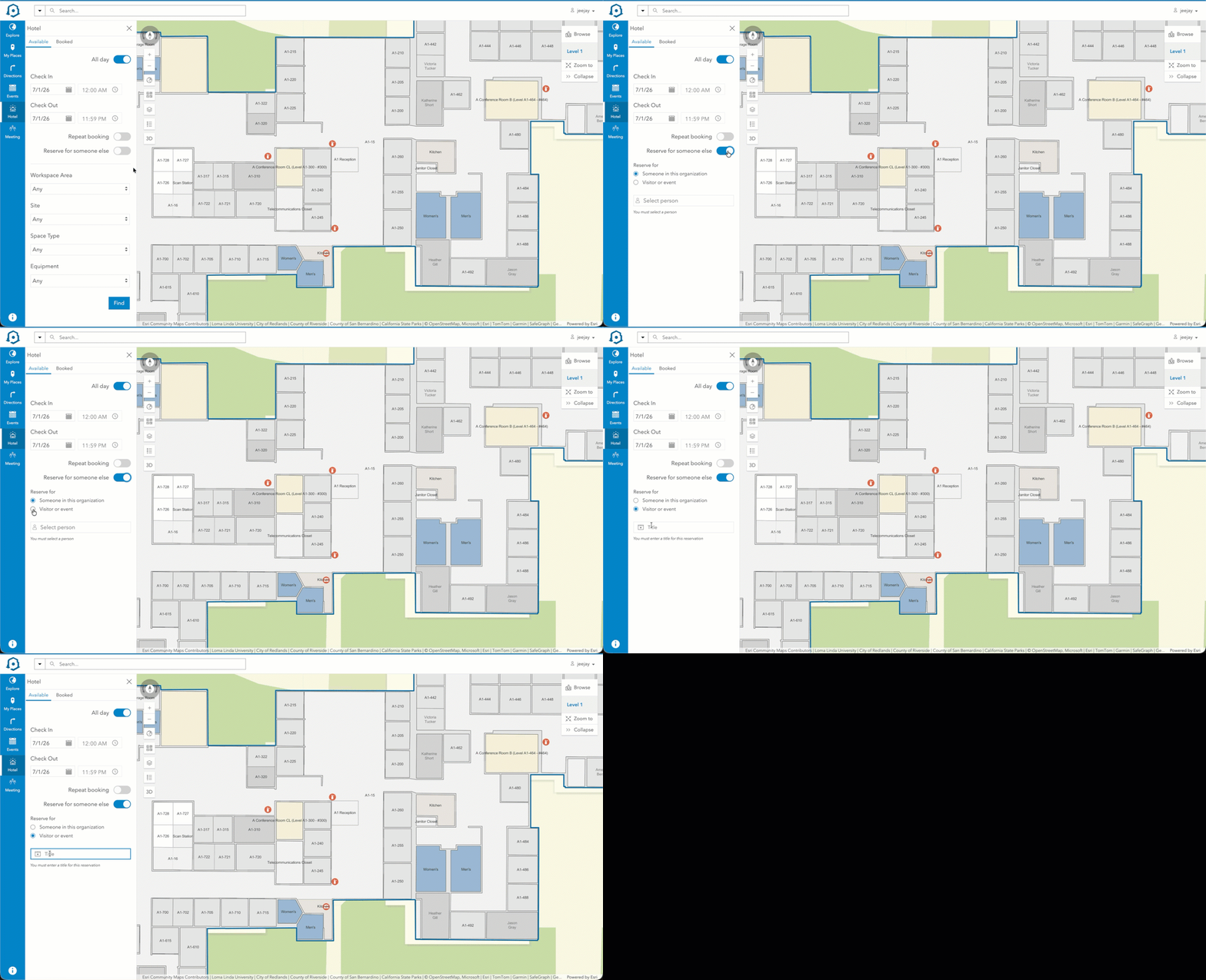
In addition to being able to book a training or a conference room on behalf of the team member who has organized the event, starting with ArcGIS Enterprise 12.1 and ArcGIS Online June update, Reservation Managers can also now book an office hotel for the visiting software vendor or guest speaker. Having an individual space reserved for them can be very helpful for any prep work needed, to catch up on notes, or for any other uses. The indoor map is also helpful to locate an office hotel that is available close to the conference room where the main session is scheduled to take place.
Scheduling Limits for Office Hotels in Hours: Finer Control Over Space Reservations
- Released in June 2026 with ArcGIS Online
The Space Planner app now provides workspace area planners with the ability to specify a scheduling limit for office hotels in maximum hours, in addition to the existing option of maximum days.
This configuration gives planners finer control to limit the duration of a reservation, ensuring office hotels are booked and occupied optimally — especially for cases where the total number of available spaces for office hoteling is limited. Organizations can now define precise time boundaries that better align with their space utilization policies and operational needs.
New Indoors Kiosk
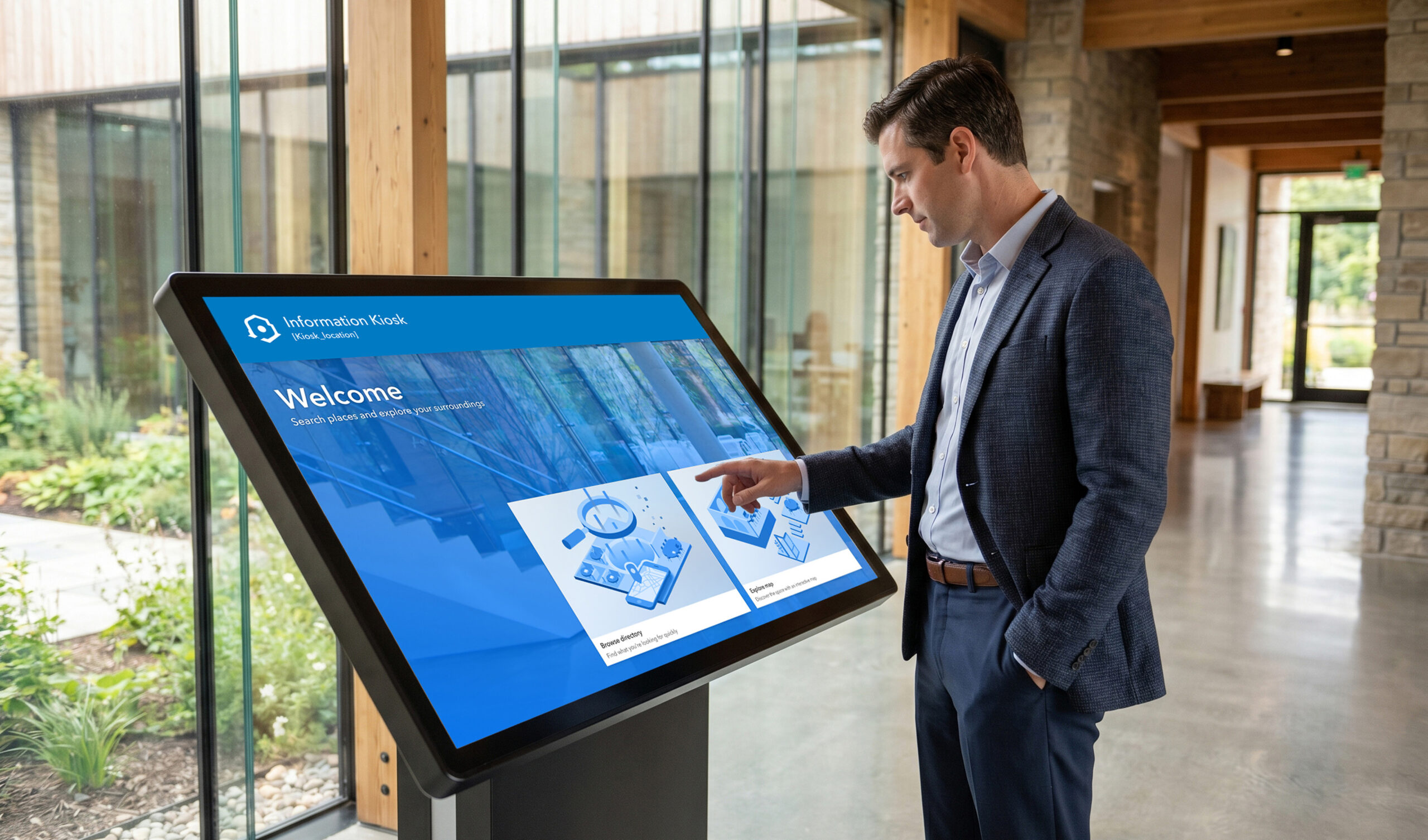
A brand-new, fully re-imagined Kiosk app is in the works—transforming the current experience into a modern, purpose-built app for exploring, wayfinding and engagement for visitors and occupants. With a responsive, branded interface and configurable welcome screens, organizations such as state and local governments, universities, airports and other transportation hubs, and hospitals can deliver tailored, location-specific experiences.
The new app also smartly handles hand-over to mobile experiences. Users can quickly search, browse, and route in the Kiosk app, then seamlessly continue their journey on mobile via App Clip by scanning QR codes—creating a connected, end-to-end visitor experience.
Sign-up for the Early Adopter program for Indoors Kiosk and ArcGIS Enterprise 12.2 Beta to get access and provide feedback to help us deliver an app that meets all your needs.
Theme 5: AI is expanding where indoor GIS is going
AI is the force multiplier that helps us better understand indoor spaces, improve positioning, and simplify user interaction with indoor GIS.
Turning Extracted Data into App-Ready Floor-Aware Maps
- Released in May 2026 with ArcGIS Pro 3.7
The ArcGIS Pro Assistant has new capabilities to help streamline the final steps of preparing indoor data for use in applications.
In addition to configuring floor-aware maps and scenes, the Pro Assistant can now evaluate whether your map is ready for web apps like Space Planner and Floor Plan Editor by identifying configuration issues and providing recommended best practices. By detecting potential issues early, it helps teams move more confidently from map authoring to app deployment.
Other Notable Highlights
Mobile Device Management Support: Simplifying Sign-In Experience
- Released in July 2026 with ArcGIS Indoors Mobile v2.3
Mobile device management (MDM) is a security software suite that allows administrators to control, secure, and enforce policies on smartphones, tablets, and other devices. MDM is a core component of enterprise mobility management (EMM). Managed app configuration enables IT administrators to deploy app settings to manage Android and iOS devices using a MDM solution.
ArcGIS Indoors Mobile app now supports managed app configuration, allowing administrators to specify the URL of their ArcGIS organization within the app. This ensures a seamless and efficient sign-in experience for users. Learn more about how to configure your ArcGIS Organization URL for Indoors Mobile.
See Matching Floors Across All Buildings: An Intuitive Visualization Experience
- Released in May 2026 with ArcGIS Enterprise 12.1
- Released in June 2026 with ArcGIS Online
The floor filter in ArcGIS Pro was previously enhanced to include a Multi Facility mode in addition to the default Single Facility mode. In Single Facility mode, only the floors of the currently selected facility change while the rest of the facilities in the site continue to show the ground level. In Multi Facility mode, the floors of all buildings in the site change based on the selected floor — particularly useful when buildings are connected to each other, or when viewing a route across different buildings.
In addition to the Indoors Mobile app, all Indoors web apps (Indoors Viewer, Space Planner, and Floor Plan Editor) in ArcGIS Online and ArcGIS Enterprise 12.1 now display matching floors across all facilities, provided the web map used by these apps is saved and shared using ArcGIS Pro 3.6 or later with Multi Facility mode active.
Note that all the features that released in May 2026 with ArcGIS Enterprise 12.1 for Windows/Linux will be available in June 2026 with the release of ArcGIS Enterprise 12.1 for Kubernetes.
ArcGIS Indoors in ArcGIS Online is now FedRAMP Moderate Authorized
ArcGIS Indoors is now included in the FedRAMP Moderate authorization for ArcGIS Online. FedRAMP is a United States government-wide program that offers a standardized approach in security assessment, authorization, and continuous monitoring in cloud products for all customers. FedRAMP includes an audit of an organization’s security program by a certified independent audit and is frequently considered as the standard for security assurance of cloud service offerings.
Following the FedRAMP Moderate authorization of ArcGIS Online, the ArcGIS Indoors team worked closely with Esri’s Software Security & Privacy team to achieve this milestone. These advancements are built directly into the existing ArcGIS Online implementation, so no migration is required.
With this update, federal and other regulated organizations can securely deploy ArcGIS Indoors apps in a compliant cloud environment, enabling indoor mapping, space management, occupant experience, and operational insights. Refer the FedRAMP section for ArcGIS Online and visit ArcGIS Trust Center for more helpful resources.
Learn more about bringing your GIS Indoors with the help of these resources.


Article Discussion: