With the White House release of guidelines for states to reopen and employees to gradually return to work, facilities are tasked with complex challenges. Managers must make decisions to ensure a safe work environment and adhere to social distancing requirements. Office layouts must be restructured for adequate spacing between workspaces and to allow for routing that minimizes close-proximity encounters. Clear communication with staff will also be a key factor: Which areas should be avoided? When has an area last be cleaned?
The ArcGIS Indoors system from Esri can help answer these geospatially focused questions for reopening the workplace. With indoor maps and an indoor positioning system, managers can create a floor-plan level awareness of the workplace, one that will allow for safe reopening.
Read more about reopening the workplace with this WhereNext Article.
Solutions Based on ArcGIS Indoors
To meet requirements for returning to the workplace, employers will need a system that provides:
- Floor plan-scale mapping of facilities
- An indoor positioning system to locate people within facilities
- A management dashboard to display key metrics associated with employees in facilities
ArcGIS Indoors is a purpose built mapping and GIS platform that can be used in a variety of indoor mapping scenarios. Currently, the full capabilities of ArcGIS Indoors are implemented using ArcGIS Enterprise as a foundation in a cloud or on-premises environment. However, in summer 2020, ArcGIS Indoors will also be available to implement in ArcGIS Online. For COVID-19 recovery and returning to the workplace, ArcGIS Indoors provides a foundation for the following use cases:
Space Management
A key component in returning to work is for workspaces to be social distancing compliant. Currently, ArcGIS Indoors supports workflows to plan and assign work locations that conform to social distancing guidelines. In the summer 2020 release, ArcGIS Indoors will offer an easy-to-deploy web application for office planning and the ability to assign areas to support a hybrid work environment of shared office spaces and working from home.
Proximity Analysis and Tracing
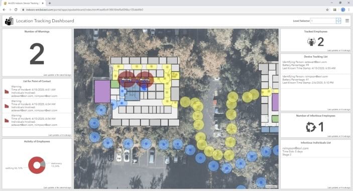
ArcGIS Indoors can support multiple proximity scenarios for recovery activities. For instance, users can perform a spatial analysis of each work location using social distancing parameters and identify areas of intersection or insufficient space. Another scenario is location tracking via the ArcGIS Indoors mobile app. Locations can be recorded as employees move through buildings, then used to determine points of contact and areas that need to be sanitized.
Density Management
For offices or schools, density management techniques are needed to manage access to shared spaces like lecture halls, conference rooms, cafés, kitchens, and other common areas. Density management is especially important for managing crowds at sporting events and concerts.
Operations and Maintenance
Organizations will need to plan, manage, and communicate facility layout, safety and sanitization projects, and identify restricted or off-limits areas. Managers, employees, and students will need to know the location and status of these projects to make informed decisions about where to travel in the facility.
Security Operations
ArcGIS Indoors software, along with associated facility data, supports the operational environment from buildings to office floor plans, campuses, and event venues. This allows leaders to understand the layout of a converted facility, anticipate threats, identify vulnerabilities, and manage risk—all without disrupting response operations, protecting lives and property.
Situational Awareness
A situational awareness dashboard built with ArcGIS Indoors provides access to all relevant information collected across multiple business lines. This includes data about the facility, staff, incidents, assets, and equipment—all in the crucial context of location.
ArcGIS Indoors Implementation Patterns
To assist your organization in getting started, Esri has defined three ArcGIS Indoors implementation patterns, referred to as levels. You can move from Level 1 to Level 2 to Level 3 as your capability requirements increase.
Level 1: Basic Recovery Capabilities
The Level 1 implementation pattern provides basic capabilities for space management, security operations, and situational awareness. This level is intended for management and awareness at the building level. A basemap with building footprints is all that is required. This level enables outdoor tracking via GPS and the ability to share the basemap via mobile phones and desktop.
Level 2: Standard Recovery Capabilities
A Level 2 implementation includes all the capabilities in Level 1 and adds the capability of mobile device tracking inside facilities. This provides advanced capabilities for space management, security operations, tracking, situational awareness, and analysis. These capabilities are key for supporting proximity analysis and tracing.
Level 3: Advanced Recovery Capabilities
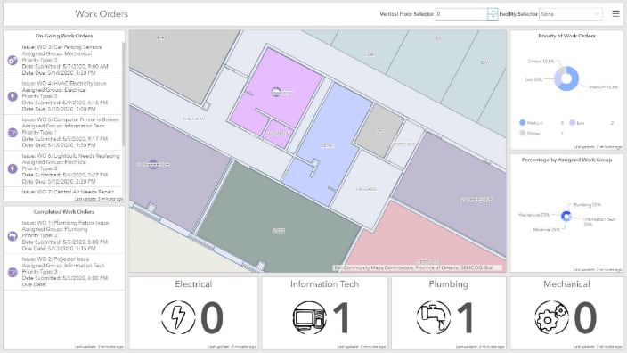
Level 3 extends the capabilities of Level 2 by adding support for notifications and alerts, routing, and work order visualization. The ArcGIS Indoors system can alert an operator when a specific event occurs. Routing makes it easier to navigate through facilities; and by adding geofences, you can help keep people away from restricted or off-limit areas. ArcGIS Indoors also connects with your work order management system for work order visualization, displaying relevant information in dashboards.
Esri is here to help
Returning to the workplace requires additional awareness of facilities—which spaces are available for use, where people can work while maintaining social distancing, and where have people traveled in the facility. To support COVID-19 recovery efforts, Esri has designed three facility mapping implementation levels leveraging the ArcGIS Indoors system. This technology helps employers reopen their workplaces while ensuring employee health and safety.
To learn more, please read the whitepaper.

Article Discussion: