ArcGIS IPS is an indoor positioning system that visualizes your real-time location inside a building as a blue dot on a map. Adding the real-time blue dot experience to indoor maps helps enhance the building occupant and visitor experience, safety and security through situational awareness, and operational efficiencies. ArcGIS IPS is currently available with ArcGIS Indoors, ArcGIS Field Maps, and ArcGIS Maps SDKs for Native Apps to create custom-built mobile apps.
The May 2024 ArcGIS IPS release brings updates in ArcGIS Pro 3.3, ArcGIS IPS Setup 1.5, and ArcGIS Maps SDKs for Native Apps 200.4 which streamline workflows, enhancing usability while simultaneously improving analytical functionalities and the indoor positioning accuracy.
ArcGIS Pro
ArcGIS Pro 3.3 introduces a completely redesigned version of the IPS information model and IPS-aware maps. These two updates provide unprecedented insights into indoor positioning data and streamline the enablement of indoor positioning.
Native GIS Support
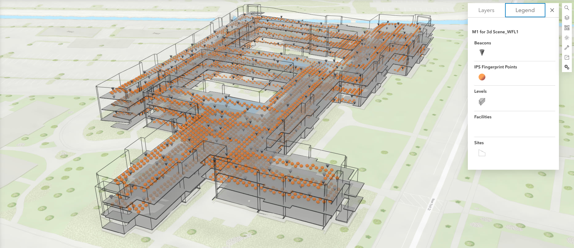
The latest version of the ArcGIS IPS information model replaces the traditional indoor positioning file (available since ArcGIS Pro 2.9) with an indoor positioning dataset which natively represents the data as point and polygon features.
The new IPS information model streamlines data management, increases transparency, and enables spatial analysis as well as more detailed quality assessment within ArcGIS Pro. This is enabled by exposing and presenting indoor positioning data in native GIS formats (points) which enables visualization on indoor maps.
For example, indoor positioning datasets can be added to a map and support floor-awareness. This provides a clear and straightforward understanding of the indoor positioning coverage through simple visual inspection.

The new Create IPS Data Model geoprocessing tool in ArcGIS Pro allows you to create the latest version of the information model and prepares the practical foundation in your workspace for upcoming ArcGIS IPS deployment actions.
Similar to the classic positioning file, an indoor positioning dataset supports both survey-less and survey-based IPS. The newly released Generate Indoor Positioning Dataset geoprocessing tool streamlines the preparation of the indoor positioning data allowing you to easily choose between the two approaches.

Leveraging Indoor Positioning Datasets, organizations and users gain practical insights that drive meaningful and informed decisions to optimize their ArcGIS IPS deployments and increase positioning accuracy.
After generation, inspection and evaluation, an indoor positioning dataset is ready for publishing.
IPS-Aware Maps
ArcGIS Pro 3.3 introduces the concept of IPS-Aware maps. Simply put, a web map that supports indoor positioning is an IPS-aware map.
Turning an Indoor Positioning Dataset into a useful source of live positioning and navigation for the end user, is a simple two-step process.
First, an ArcGIS IPS administrator (owner or manager of an ArcGIS IPS enabled facility) shares a selected Indoor Positioning Dataset to their ArcGIS IPS-licensed ArcGIS Enterprise or ArcGIS Online organization using the Share Indoor Positioning Data Service geoprocessing tool. Second, they configure (select) that shared service as a property of a web map, which makes the map IPS-aware.

The benefit of IPS-aware maps lies in their versatility and compatibility. The same Indoor Positioning Data Service can be used to enable indoor positioning on multiple web maps, eliminating redundancy and simplifying data management.
While IPS-aware maps represent the newest advancement in indoor positioning technology, users still have access to traditional indoor positioning files through the “classic” toolset, ensuring compatibility with existing workflows.
Survey-less IPS deployments updates
In the previous release of ArcGIS IPS, a new, survey-less positioning data generation method was introduced, making the time-consuming collection of radio signal data inside the building obsolete.
This release of ArcGIS IPS comes with improvements to this functionality and includes an option to update survey-less IPS setups within the new Generate Indoor Positioning Dataset tool which allows the option to update an existing dataset, not just create a new one.
If the performance of survey-less IPS does not meet the use case requirements in limited areas, and the positioning accuracy is insufficient, optimizations can be applied. You can create quality recordings that help identify affected areas and then collect survey data there. This data can then be seamlessly blended with the existing survey-less dataset, allowing for an improved indoor positioning performance.
This means that with the Positioning Data Update feature, users can easily refine existing positioning datasets saving time and resources while ensuring optimal positioning and navigation accuracy with minimal effort.
ArcGIS IPS Setup
The ArcGIS IPS Setup app version 1.5 comes with updates designed to enhance the user experience and streamline functionalities. These are reflected by a smoother journey through the diverse modes of the app, optimizing workflows and delivering enhanced efficiency.
Upon map load, a user can – when available – immediately see their live indoor position. With the blue dot being available from the start, testing the indoor positioning performance is fortified as the core functionality of the app.
IPS Survey productivity has been improved with inclusion of floor-awareness in survey planning and execution workflows. Adding floor awareness allows users to browse their facilities and floors after starting Survey mode.
The creation of Quality recordings has also been updated as the IPS Engine runs continuously in the background from map load. Additional warnings and error messages provide the user deeper insights into the quality of their indoor positioning data (map configuration) as well as the positioning performance. Meanwhile, more specific positioning details can now be enabled from the user profile menu and provide ArcGIS IPS deployment admins more precise IPS Engine information.

ArcGIS Maps SDKs for Native Apps
The 200.4 release of ArcGIS Maps SDK for Kotlin, Swift, Qt and .NET introduces a new IndoorPositioningDefinition property on the map class. The IndoorPositioningDefinition encapsulates all relevant information from an IPS-aware map which makes it easy to use. The IndoorsLocationDataSource was also enhanced with a new constructor, consuming only the IndoorPositioningDefinition object. This offers a straightforward, backwards-compatible and future-proof approach for using IPS information carried by IPS-aware maps.
In case where indoor positioning performance should be tailored for custom requirements, application developers can use the new IndoorsLocationDataSourceConfiguration class to fine-tune specific IPS parameters such as whether to activate path snapping, adjusting path-snapping distance, enable or disable a localization sources fallback (for GNSS and/or AppleIPS), as well as internal position fusion algorithm settings.
While the ArcGIS IPS product continues improving with the new above-mentioned formats, algorithms, features and workflows, geoprocessing tools to create and use the traditional indoor positioning files are still available and the new IndoorPositioningDefinition includes the support for classic IPS maps.
Visit the product page to learn more about ArcGIS IPS, and join us on the Esri Community to ask questions, submit your product ideas and learn from peers.


Commenting is not enabled for this article.