We are excited for you to join us at this year’s 2025 Esri User Conference, July 15-19 in San Diego, California. As you plan your attendance for the mappiest week of the year either in person or virtually, check out the following resources to find all things ArcGIS Living Atlas of the World and Ready-to-Use Content.
If you’re new to ArcGIS Living Atlas, it is the largest digital repository of spatial content in the world, and it is built directly into ArcGIS. This massive collection of ready-to-use content is designed to kickstart your workflows, and provide authoritative content that can be trusted. There are many beginner technical sessions and demo theaters at the UC designed to help get you started with Living Atlas.
If you’re already familiar with Living Atlas, there are intermediate sessions, new resources, new content, and updates valuable to your workflows. There are also demo theaters containing tips and tricks that you won’t want to miss.
This year’s theme for the conference is GIS – Integrating Everything, Everywhere. GIS transcends boundaries, integrates knowledge, data, content, analytics, and empowers individuals and organizations to create positive change. This is at the core of what Living Atlas has to offer, containing spatial content BY the GIS community FOR the GIS community.

Find Living Atlas in the UC Expo
Visit us at the showcase to learn more, ask questions, talk with subject matter experts, or see demos of the latest content available within Living Atlas. Esri curators are available to discuss how you can nominate your own content, making your information more accessible to GIS communities worldwide. Find us near Demo Theater 11 in the back near Tech Support. We are nearby to related products like ArcGIS Online, ArcGIS Apps, and Location Data. If need help finding us, the Info booth is in the center of the Expo and someone can help you navigate the room.
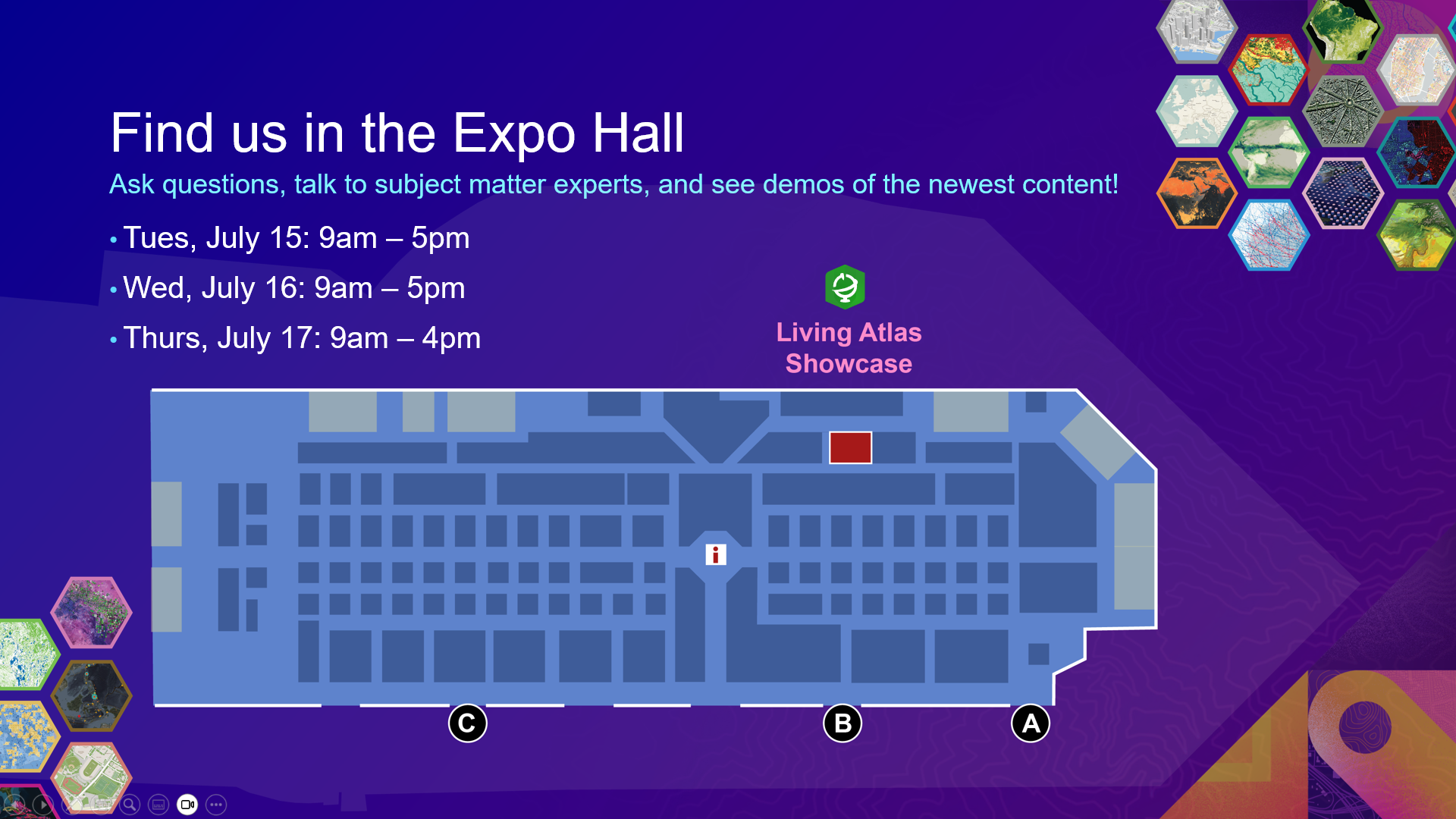
Showcase Hours
- Tuesday, July 15, 9 am – 5 pm PT
- Wednesday, July 16, 9 am – 5 pm PT
- Thursday, July 17, 9 am – 4 pm PT
Attend Living Atlas Sessions
As you plan your busy week, check out the sessions highlighting ArcGIS Living Atlas. We have Beginner and Intermediate sessions to help you learn more about topics like Imagery, Basemaps, Sustainability, Open Data, Demographics, Community Maps, Policy, and so much more. These sessions presented by subject matter experts provide best practices and technical demonstrations of the latest content within Living Atlas.
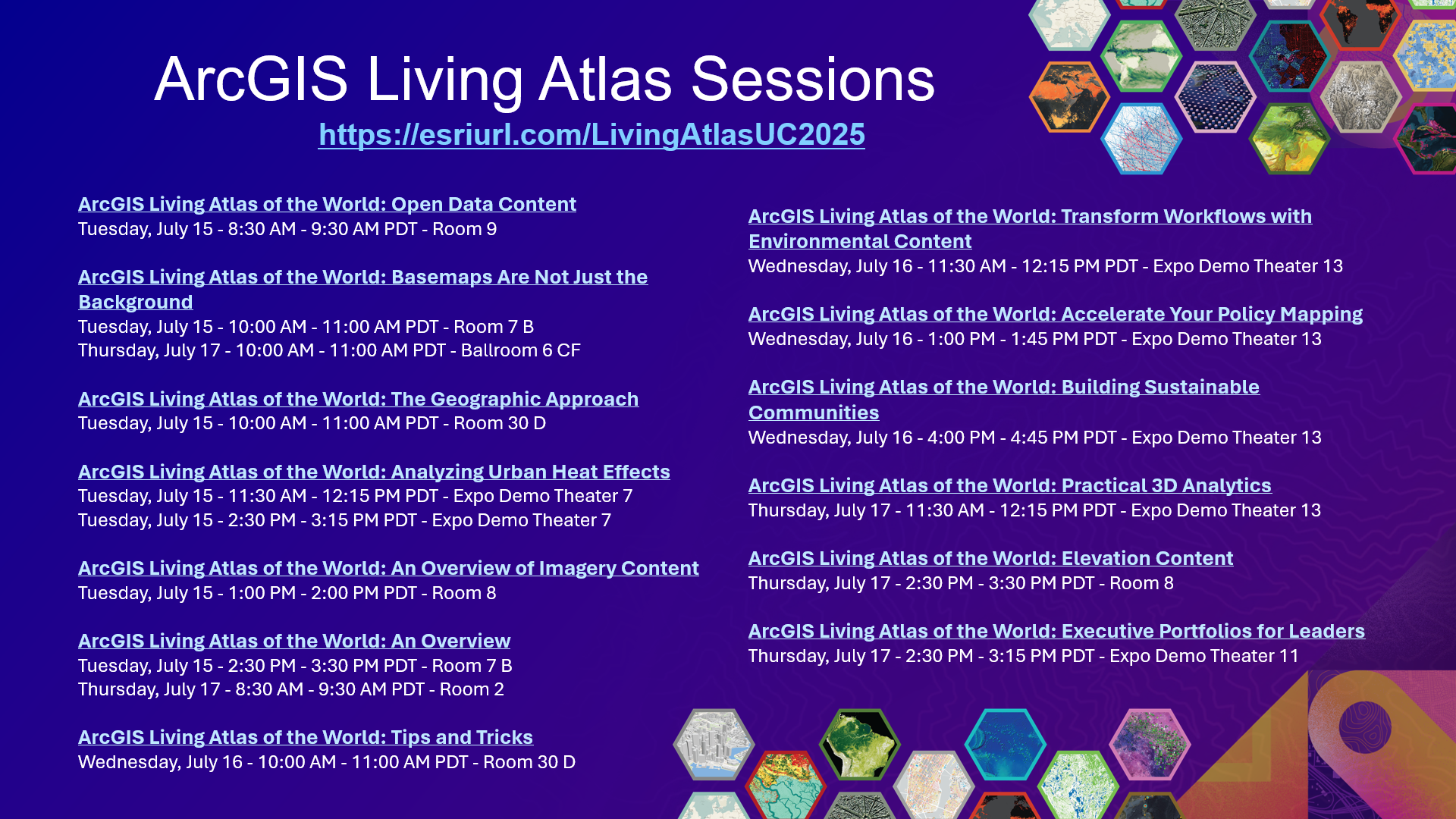
Tip: Save the image above on your phone for easy reference later or save this url: https://esriurl.com/LivingAtlasUC2025
ArcGIS Living Atlas of the World: Open Data Content
Tuesday, July 15 – 8:30 AM – 9:30 AM PDT
Get to know ArcGIS Living Atlas of the World’s most useful datasets, including global data sources such as OpenStreetMap and Overture Maps. ArcGIS Living Atlas includes a large and growing collection of open data layers. Discover how to easily access this data through ArcGIS to create maps and apps, perform analysis, and generate derivative datasets and services. Also, learn how you can share your own authoritative data.
ArcGIS Living Atlas of the World: Basemaps Are Not Just the Background (Live Streamed Session)
Tuesday, July 15 – 10:00 AM – 11:00 AM PDT
Thursday, July 17 – 10:00 AM – 11:00 AM PDT
Basemaps are the foundation for your maps and apps, but they are also part of the story that you are telling. Discover the integral role that basemaps play in developing your maps, and learn about available options through ArcGIS Living Atlas and how to choose appropriate basemaps. Explore how to use tools in ArcGIS Pro and Map Viewer to build your own basemap versions with the ArcGIS Vector Tile Style Editor.
ArcGIS Living Atlas of the World: The Geographic Approach (Live Streamed Session)
Tuesday, July 15 – 10:00 AM – 11:00 AM PDT
The Geographic Approach is a problem-solving method that organizes relevant information within the crucial context of location. This presentation will guide you through the basics of applying the Geographic Approach to your GIS workflows. Learn to source ready-to-use content from ArcGIS Living Atlas of the World, summarize information, visualize results, and communicate findings to your audience.
ArcGIS Living Atlas of the World: Analyzing Urban Heat Effects
Tuesday, July 15 – 11:30 AM – 12:15 PM PDT
Tuesday, July 15 – 2:30 PM – 3:15 PM PDT
Analyze the heat island effect on urban populations around the world. Learn how you can process, analyze, and derive insights using imagery and raster data from ArcGIS Living Atlas of the World—all within a single secure system. Discover the power of combining ArcGIS Image analysis capabilities with more than 40 years of Landsat data. Speakers also discuss how to create derivative maps with ArcGIS Notebooks and distribute insights with information products in ArcGIS Online.
ArcGIS Living Atlas of the World: An Overview of Imagery Content
Tuesday, July 15 – 1:00 PM – 2:00 PM PDT
Are you new to imagery or looking for ways to leverage raster analysis? This presentation discusses the fundamentals of ready-to-use imagery in ArcGIS Living Atlas of the World as well as the various types of imagery available and how to access them. Learn about a variety of available sources and best practices for using ArcGIS Living Atlas imagery in various workflows, custom apps, Map Viewer, ArcGIS Pro, and ArcGIS Notebooks.
ArcGIS Living Atlas of the World: An Overview (Live Streamed Session)
Tuesday, July 15 – 2:30 PM – 3:30 PM PDT
Thursday, July 17 – 8:30 AM – 9:30 AM PDT
Discover the world’s foremost collection of geospatial information. ArcGIS Living Atlas of the World curates ready-to-use maps, apps, and layers from Esri and the global GIS user community. Find out how to use this content—and contribute to it—to support work across the ArcGIS system. Speakers will also showcase recent additions and updates to ArcGIS Living Atlas.
ArcGIS Living Atlas of the World: Tips and Tricks (Live Streamed Session)
Wednesday, July 16 – 10:00 AM – 11:00 AM PDT
Are you using ArcGIS Living Atlas of the World to its full potential? With ArcGIS Living Atlas, you have access to spatial content that is available for use in ArcGIS Online and ArcGIS Pro, among other common GIS workflows. Join us to learn some tips and tricks to implement in your work when using ArcGIS Living Atlas. Go beyond the basics to customize layers, maps, and apps for your needs. Gain best practices for improving your existing workflows, both analytically and cartographically. Save time and kick-start your GIS workflows by using the power of ArcGIS Living Atlas and the Geographic Approach.
ArcGIS Living Atlas of the World: Transform Workflows with Environmental Content
Wednesday, July 16 – 11:30 AM – 12:15 PM PDT
Enrich your own data with ready-to-use global environmental content available in ArcGIS Living Atlas of the World. Learn how to access and explore content, use the latest analysis tools to address critical environmental issues, and gain cartographic and visualization best practices to produce clear, understandable, and sharable maps for your audience.
ArcGIS Living Atlas of the World: Accelerate Your Policy Mapping
Wednesday, July 16 – 1:00 PM – 1:45 PM PDT
Create data-driven policy maps that drive research, analysis, and action. A good policy map answers a specific question and inspires more: What is the current situation? How has it changed over time? Which areas are doing well, or not so well? Which actions are proposed, and where? Learn which types of policy maps are needed at each stage of a policy’s life cycle, and explore ready-to-use information in ArcGIS Living Atlas of the World that can expedite your policy mapping project.
ArcGIS Living Atlas of the World: Building Sustainable Communities
Wednesday, July 16 – 4:00 PM – 4:45 PM PDT
This session uses Living Atlas layers to better understand the impacts of coastal and riverine flooding on communities. Speakers will demonstrate an example by combining layers from Living Atlas with other publicly available flood data to map historical floods and future flooding scenarios, to understand the associated impacts. They will also show how 3D resources can help communicate the impact of flooding.
Esri U.S. Demographics: What’s New
Thursday, July 17 – 10:00 AM – 10:45 AM PDT
Learn what’s new in the latest U.S. update for Esri Demographics, including the next-generation ArcGIS Tapestry system and expanded income and home value data.
ArcGIS Living Atlas of the World: Practical 3D Analytics
Thursday, July 17 – 11:30 AM – 12:15 PM PDT
Embark on a journey through 3D analytics and the layers of ArcGIS Living Atlas of the World. Explore data about extreme weather processes and sea-level rise. Discover how common 3D analytics are used with web layers and services from sources like ArcGIS Living Atlas and get tips for how to enrich your GIS with 3D-ready information.
ArcGIS: Using Demographic Content
Thursday, July 17 – 11:30 AM – 12:15 PM PDT
Make demographic data shine with ArcGIS. Whether you work in ArcGIS Online or ArcGIS Pro—whether you are a GIS expert or beginner—this presentation has something for everyone. Learn how to find, apply, and visualize ready-to-use demographic content from Esri Demographics, the U.S. Census Bureau, and global statistical agencies for your analyses and workflows.
ArcGIS Living Atlas of the World: Elevation Content
Thursday, July 17 – 2:30 PM – 3:30 PM PDT
Access terabytes of authoritative elevation data as ready-to-use layers and tools. Discover the elevation layers and tools (profile, viewshed) that are available in ArcGIS Living Atlas of the World. Learn to access these resources from ArcGIS Online and ArcGIS Pro for your GIS workflows, including 2D and 3D visualization and analysis. Gain best practices for filtering data from global layers for your terrain analysis—without needing to download data locally.
ArcGIS Living Atlas of the World: Executive Portfolios for Leaders
Thursday, July 17 – 2:30 PM – 3:15 PM PDT
Your GIS team is valuable, and your organizational leadership needs to know. Learn to create an executive map portfolio in less than an hour, using layers and maps from ArcGIS Living Atlas of the World and your organization. In this demo theater presentation, speakers will take audience suggestions and walk through the process of building a map portfolio. Speakers will discuss what an executive-ready map includes and share key lessons from decades of experience serving information products to executives. Get started building and maintaining your own executive map portfolios.
Need Living Atlas support before or after the UC?
Visit the Living Atlas website for the latest news on what’s new.
See if your question is answered in this blog: Your Living Atlas Questions Answered.
Join the conversation at the Living Atlas Esri Community page.
It’s Not Too Late to Register for UC 2025
Register today to attend in-person, virtually with digital access, or for the plenary only. We look forward to seeing you in-person in San Diego or online and wish you a wonderful User Conference 2025!
Join the plenary session on Monday July 14, 2025 to explore why a holistic, location-based understanding of our world can both unite and empower us to affect positive change. You’ll see Living Atlas in many of the plenary demos, by both Esri users and Esri staff. Try to count how many times you see or hear Living Atlas referenced on stage this year!

Article Discussion: